
Bure-les-Templiers
| Bure-les-Templiers | ||
|---|---|---|
.svg)
|
|
|
| region | Bourgogne-Franche-Comté | |
| Department | Côte-d'Or | |
| Arrondissement | Montbard | |
| Canton | Châtillon-sur-Seine | |
| Community association | Communauté de communes du Pays Châtillonnais | |
| Coordinates | 47 ° 44 ' N , 4 ° 54' E | |
| height | 302-483 m | |
| surface | 35.03 km 2 | |
| Residents | 134 (January 1, 2017) | |
| Population density | 4 inhabitants / km 2 | |
| Post Code | 21290 | |
| INSEE code | 21116 | |
.jpg) Bure-les-Templiers |
||

Bure-les-Templiers is a French municipality with 134 inhabitants (at January 1, 2017) in the department of Côte-d'Or in the region Bourgogne Franche-Comté . It belongs to the canton of Châtillon-sur-Seine and the arrondissement of Montbard .
Neighboring municipalities are Recey-sur-Ource in the north-west, Menesble in the north, Colmier-le-Bas and Chaugey in the north-east, Villars-Santenoge in the east, Poinson-lès-Grancey in the south-east, Beneuvre in the south, Minot in the south-west and Saint-Broing- les-Moines and Terrefondrée to the west.
Population development
| year | 1962 | 1968 | 1975 | 1982 | 1990 | 1999 | 2008 | 2015 |
|---|---|---|---|---|---|---|---|---|
| Residents | 235 | 211 | 172 | 154 | 130 | 150 | 130 | 138 |
Attractions
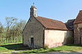
The Romanesque chapel of Saint-Renobert de Romprey, a historic monument since 1996
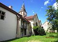
The Romanesque church of Saint-Julien, a historic monument since 1927

The castle in the Romprey district


Web links
Commons : Bure-les-Templiers - collection of images, videos and audio files