Poiseul-la-Ville-et-Laperrière
| Poiseul-la-Ville-et-Laperrière | ||
|---|---|---|
|
|
||
| region | Bourgogne-Franche-Comté | |
| Department | Côte-d'Or | |
| Arrondissement | Montbard | |
| Canton | Châtillon-sur-Seine | |
| Community association | Pays Châtillonnais | |
| Coordinates | 47 ° 34 ′ N , 4 ° 40 ′ E | |
| height | 338-462 m | |
| surface | 21.64 km 2 | |
| Residents | 160 (January 1, 2017) | |
| Population density | 7 inhabitants / km 2 | |
| Post Code | 21450 | |
| INSEE code | 21490 | |
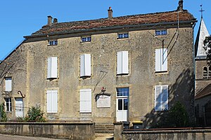
 Old Town Hall (Mairie) of Poiseul-la-Ville-et-Laperrière |
||
Poiseul-la-Ville-et-Laperrière is a French municipality with 160 inhabitants (as of January 1, 2017) in the Côte-d'Or department in the region of Bourgogne Franche-Comté (before 2016 Bourgogne ); it belongs to the arrondissement of Montbard and the canton of Châtillon-sur-Seine (until 2015 Baigneux-les-Juifs ).
geography
Poiseul-la-Ville-et-Laperrière is located about 38 kilometers northwest of Dijon on the Seine , which borders the municipality in the northeast. Poiseul-la-Ville-et-Laperrière is surrounded by the neighboring communities Baigneux-les-Juifs in the north, Orret in the northeast, Oigny in the east and northeast, Billy-lès-Chanceaux in the east and southeast, Frôlois in the south and west and La Villeneuve -les-conversations in the west.
Population development
| year | 1962 | 1968 | 1975 | 1982 | 1990 | 1999 | 2006 | 2013 |
| Residents | 255 | 254 | 230 | 202 | 183 | 181 | 168 | 162 |
| Source: Cassini and INSEE | ||||||||
Attractions
- Saint-Victor church, historic monument since 1947
- Saint-Nicolas chapel from the 16th century, a historic monument since 1990


