Saint-Julien – Gray railway line
| Saint-Julien-Gray | |||||||||||||||||||||||||||||||||||||||||||||||||||||||||||||||||||||||||||||||||||||||||||||||||||||||||||||||||||||||||||||||||||||||||||||||||||||||||||||||||||||||||||||||||||||||||||||||||||||||||||||||||||||||||||||||||||||||||||||||||||||||||||||||||||||||||||||||||||||||||||||||||||||||||||||||||||||||||||||||||||||||||||||||||||||||||||||||||||||||||||||
|---|---|---|---|---|---|---|---|---|---|---|---|---|---|---|---|---|---|---|---|---|---|---|---|---|---|---|---|---|---|---|---|---|---|---|---|---|---|---|---|---|---|---|---|---|---|---|---|---|---|---|---|---|---|---|---|---|---|---|---|---|---|---|---|---|---|---|---|---|---|---|---|---|---|---|---|---|---|---|---|---|---|---|---|---|---|---|---|---|---|---|---|---|---|---|---|---|---|---|---|---|---|---|---|---|---|---|---|---|---|---|---|---|---|---|---|---|---|---|---|---|---|---|---|---|---|---|---|---|---|---|---|---|---|---|---|---|---|---|---|---|---|---|---|---|---|---|---|---|---|---|---|---|---|---|---|---|---|---|---|---|---|---|---|---|---|---|---|---|---|---|---|---|---|---|---|---|---|---|---|---|---|---|---|---|---|---|---|---|---|---|---|---|---|---|---|---|---|---|---|---|---|---|---|---|---|---|---|---|---|---|---|---|---|---|---|---|---|---|---|---|---|---|---|---|---|---|---|---|---|---|---|---|---|---|---|---|---|---|---|---|---|---|---|---|---|---|---|---|---|---|---|---|---|---|---|---|---|---|---|---|---|---|---|---|---|---|---|---|---|---|---|---|---|---|---|---|---|---|---|---|---|---|---|---|---|---|---|---|---|---|---|---|---|---|---|---|---|---|---|---|---|---|---|---|---|---|---|---|---|---|---|---|---|---|---|---|---|---|---|---|---|---|---|---|---|---|---|---|---|---|---|---|---|---|---|---|---|---|---|---|---|---|---|---|---|---|---|---|---|---|---|---|---|---|---|---|---|---|---|---|---|---|---|---|---|
|
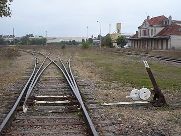
Châtillon-sur-Seine train station with symmetrical double turnouts, 2016
| |||||||||||||||||||||||||||||||||||||||||||||||||||||||||||||||||||||||||||||||||||||||||||||||||||||||||||||||||||||||||||||||||||||||||||||||||||||||||||||||||||||||||||||||||||||||||||||||||||||||||||||||||||||||||||||||||||||||||||||||||||||||||||||||||||||||||||||||||||||||||||||||||||||||||||||||||||||||||||||||||||||||||||||||||||||||||||||||||||||||||||||
| Route number (SNCF) : | 838,000 | ||||||||||||||||||||||||||||||||||||||||||||||||||||||||||||||||||||||||||||||||||||||||||||||||||||||||||||||||||||||||||||||||||||||||||||||||||||||||||||||||||||||||||||||||||||||||||||||||||||||||||||||||||||||||||||||||||||||||||||||||||||||||||||||||||||||||||||||||||||||||||||||||||||||||||||||||||||||||||||||||||||||||||||||||||||||||||||||||||||||||||||
| Route length: | 186 km | ||||||||||||||||||||||||||||||||||||||||||||||||||||||||||||||||||||||||||||||||||||||||||||||||||||||||||||||||||||||||||||||||||||||||||||||||||||||||||||||||||||||||||||||||||||||||||||||||||||||||||||||||||||||||||||||||||||||||||||||||||||||||||||||||||||||||||||||||||||||||||||||||||||||||||||||||||||||||||||||||||||||||||||||||||||||||||||||||||||||||||||
| Gauge : | 1435 mm ( standard gauge ) | ||||||||||||||||||||||||||||||||||||||||||||||||||||||||||||||||||||||||||||||||||||||||||||||||||||||||||||||||||||||||||||||||||||||||||||||||||||||||||||||||||||||||||||||||||||||||||||||||||||||||||||||||||||||||||||||||||||||||||||||||||||||||||||||||||||||||||||||||||||||||||||||||||||||||||||||||||||||||||||||||||||||||||||||||||||||||||||||||||||||||||||
|
|||||||||||||||||||||||||||||||||||||||||||||||||||||||||||||||||||||||||||||||||||||||||||||||||||||||||||||||||||||||||||||||||||||||||||||||||||||||||||||||||||||||||||||||||||||||||||||||||||||||||||||||||||||||||||||||||||||||||||||||||||||||||||||||||||||||||||||||||||||||||||||||||||||||||||||||||||||||||||||||||||||||||||||||||||||||||||||||||||||||||||||
The Saint-Julien – Gray line is a single-track , non-electrified, 186 km long railway line in France , most of which is no longer in operation. It ran parallel to the two lines Paris – Mulhouse and Paris – Marseille in a north-west-south-east direction and had connections to them in several places. It went into operation in 1863.
This stretch crossed the watershed between the waterways of the Seine and Rhône river systems.
Building history
This line is one of the early rail lines that was licensed for the Chemin de fer de l'Est (EST). The construction for the first section between Troyes and Bar-sur-Seine was approved by an imperial decree on January 21, 1857. The line went into operation on October 28, 1888.
During the First World War, this route was considered strategically important and was preferred for transport purposes. There were no damages to the route.
Viaduc d'Oisilly
The Viaduc d'Oisilly railway bridge , made of local sandstone, stands out as the largest single structure ; with its 293.9 m length and a height of 18 m it spans the Vingeanne valley and the parallel canal entre Champagne et Bourgogne . The passage between the arches is 37 m. At the World Exhibition in Paris in 1889 , a model was exhibited on the CE stand, because this building was considered a masterpiece of its engineers. The actual construction time was 18 months. While in June 1886 the foundations were created with a depth of up to nine meters, the erection of the stone pillars was carried out during the year 1887. From January 1888 the first test drives could be undertaken. The construction was subject to very tight tolerances: deviations between three vaults were only allowed to be two millimeters.
Line closure
The line was closed on the recommendation of the Guillaumat report. The officer's son Pierre Guillaumat had been concerned with fuel issues since 1944, initially under Charles de Gaulle as Directeur des carburants , later as Director of the state Bureau des recherches de pétrole and, from 1951 to 1958, as General Director of the Commissariat à l'énergie atomique et aux énergies alternative . From 1966 to 1977 he was also President of the then mineral oil company Elf Aquitaine . With the oil price crisis , the state finally lost faith in the value of a comprehensive railway infrastructure after the first closings had already taken place with the dismantling of the first lines from two to one track in World War II. In 1974 it was believed that the solution to the loss-making operation was found by putting funds from the budget for public transport (Établissement public régional, EPR) into promoting the expansion of the road network. This paradigm shift went under the unsuspicious name of Schémas Régionaux de transports collectifs (SRTC) . Numerous line closings and the end of this line were the result.
In this report, which appeared in 1978 on behalf of the French government, rail was given a marginal role in passenger transport outside the main roads. In order to implement these plans, a simple logic was used: a law released the state railway SNCF from the maintenance of its route network, which it was happy to comply with. As a second lever, this law also called on the transport company to increase the number of regional service agreements with local authorities, for example regional authorities, also outside the SRTC. This second point was only moderately successful in terms of its objectives: regional authorities are less eager than the state to take responsibility for unpopular measures that directly affect their citizens. Nevertheless, in the five years 1976 to 1981 alone, over 800 km of the route network were closed.
The early closings mainly included routes that ran a long way from the main thoroughfares, while direct connections to these main traffic axes were only affected in a second step. In a second pass, long sections, some of which were over 100 km away, were closed, including this Saint-Julien-Gray railway line, which included the section to Vesoul, which was seen as a single unit from an operational point of view and was mostly used continuously around the Relieve the Paris – Mulhouse line. From the mid-1980s, especially after the establishment of the Transport express régional (TER), the responsibility for the closure passed more and more into the hands of the regions. In contrast, lines that were not closed were given overhead lines. This phase was completed by 1997 and there were practically no shutdowns in the next ten years.
Individual evidence
- ↑ N ° 4319 - Décret impérial relatif à l'exécution d'un chemin de fer d'embranchement de Bar-sur-Seine à la ligne de Paris à Mulhouse, et d'un chemin de fer de raccordement de ladite ligne avec celle de Paris à Vincennes et Saint-Maur: 21 janvier 1857 , Bulletin des lois de l'Empire Français, Paris, Imprimerie Impériale 1857, Volume XI, Volume 14, No. 466, Pages 137-140.
- ^ A b Joseph Allard: Notice sur la Construction du Viaduc d'Oisilly . In: Mémoires et compte-rendu des travaux de la société des ingénieurs civils , Société des Ingénieurs civils, Paris 1889, pages 953–959 (French)
- ↑ A. Marchand: Les chemins de fer de l'Est et la guerre de 1914–1918 , Berger-Levrault, Nancy 1924, o. P.
- ^ Raymond Haïm Lévy: Pierre Guillaumat, 1909-1991 . In: La Jaune et la Rouge. Association des anciens élèves et diplômés de l'École polytechnique , May 1993, pages 46–50, on: Webarchive.org (French)
- ↑ a b c Etienne Auphan: The contraction du réseau ferré français dans le temps et dans l'espace . In: FERINTER, International Railway Studies (French)


