
Bandipur (Nepal)
| Bandipur Nagarpalika बन्दीपुर नगरपालिका Bandipur |
|||
|---|---|---|---|
|
|||
| Coordinates | 27 ° 56 ′ 0 ″ N , 84 ° 25 ′ 0 ″ E | ||
| Basic data | |||
| Country | Nepal | ||
| Gandaki | |||
| ISO 3166-2 | NP-P4 | ||
| District | Tanahu | ||
| height | 995 m | ||
| surface | 73 km² | ||
| Residents | 15,591 (2011) | ||
| density | 213.5 Ew. / km² | ||
| founding | May 18, 2014 | ||
| Website | bandipurmun.gov.np | ||
| politics | |||
| Chief Executive Officer | Bhagirath Regmi (October 2015) | ||
| 11 wards | |||
 Bandipur
|
|||


Bandipur ( Nepali बन्दीपुर Bandīpur ) is a mountain town in the Tanahu district in central Nepal .
Bandipur was merged in 2014 with some neighboring villages (the former VDC Dharampani ) to form one city ( municipality / Nagarpalika ).
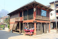
It is located on a narrow 200 m long saddle at a height of 1000 m between two approx. 1300 m high mountain peaks in the Mahabharat Mountains. The northern flank of the saddle falls into the Marsyangdital , which is about 700 m lower, with the through road from Kathmandu (143 km east) to Pokhara (80 km west) and the town of Dumre. The saddle is just wide enough for the main road and the two-sided, two-to-three-storey wooden and adobe houses in closed construction. The gardens at the back on either side descend steeply into the valleys and are only accessible by stairs. The location is a little reminiscent of Machu Picchu .
Residents
At the 2011 census, the VDCs, from which the city of Bandipur emerged, had 15,591 inhabitants (7068 of them male) in 3780 households.
history
Bandipur, originally a Magar village, was brought to bloom in the 19th century by Newari from Bhaktapur in the Kathmandu valley. The closed construction with 2-3 storeys gave the place a small town character, which it has kept to this day. The Newari settled here at the crossroads of the old trade routes from India to Tibet and from Kathmandu to Jumla after Prithvi Narayan Shah had unified the country and wanted to promote trade. The architecture of this merchant people has largely been preserved, even if it is often in need of renovation. The town continued to flourish until the road was built in the valley in the late 1960s. With the completion of the road, trade dried up almost suddenly. Many residents moved down into the valley to Dumre or even into the Terai . The former prosperity can only be seen in the trading houses and also in the damaged main street.
Until 1998 there was only one unpaved road from Dumre to Bandipur, which, however, was hardly accessible in the monsoons and only accessible by tractors or all-terrain vehicles. It was not until 1998 that the 8 km long route for motor vehicles was expanded and paved, making it passable all year round, but landslides can still cut the place off from the outside world. A peculiarity of Bandipur was that the streets of the place were originally paved with silvery slabs of up to 1/4 m² in size. Under the load of the aforementioned tractors, the areas accessible to the vehicles were smashed and the pavement can only be seen at the edge areas.
The quiet place was turbulent three times in the 1960s and 1970s. First there was the fight for the leadership of the overland road from Kathmandu to Pokhara, which for technical reasons was understandably placed in the valley, but practically cut off this important place from the outside world.
In the 1970s, when the first demonstrations for democracy took place in Nepal, the small garrison in the village was stormed, resulting in several deaths and the soldiers fled. This garrison still exists, a relic from the times as a trading center.
With the first democratic approaches, the country was divided into new administrative districts. Due to its unfavorable location, the existing district administration was moved to a more central location. Again the citizens demonstrated and arrested the administration. She then had to leave secretly at night and in fog. There had been so much commotion that even the king flew in by helicopter.
There are other relics from better times, for example the importance of Bandipur as a school location for the towns in the larger area. Most unusual for a place of this size and location is a small library, the building of which, in the middle of one end of the main street, was restored in 2000. Equally unusual is the Tundikhel , a level place the size of a football field on a mountain ledge that slopes steeply to the Marsyangdital. This place was and still is used for exercise, events and sports, sometimes as a helicopter landing pad. There are often monkeys on the square who venture out of the surrounding jungle. Due to its interesting history and good viewpoint, there are approaches to stimulate tourism. In addition to a few small pensions, a small resort (hotel) has settled at the northern end of the Tundikhel, about 1 km from Bandipur.
population
Bandipur was originally a Magar village. Today a number of different ethnic groups live in this place: Bahun , Chhetri , Newari , Damai , Kami , Sarki , Kasai , Magar and Gurung .
Economy and tourism
After the road was built in the valley to Dumre or the Terai , business and trade moved. Some residents rent their houses as boarding houses for the students who find it too long to walk home to the surrounding villages every day. More recently, some have tried growing oranges, for which the climate in Bandipur is thriving. A silkworm farm is an hour's walk west . Many Magar and Gurung serve as Gurkha soldiers. The location of Bandipur in medium height with the view of Dhaulagiri , Annapurna , Manaslu , Ganesh , Langtang Himal , the Marsyangdital, the Manakamana Mountain and Gorkha with the high palace offer suitable conditions for a modest tourism. The seclusion of the place has proven to be a salvation for the Newari architecture, which otherwise would certainly have fallen victim to modern construction methods. At the right time, visitors can witness Newar or Magar festivals, which so far only take place several times a year for their own purposes. Interesting buildings are the Bindyabashini Temple and the library in the center, Thani Mai and Tindhara (“three faucets” washing area on the southeastern foothills of Bandipur). Excursion destinations are the Raniban ("Queen's Forest") and the largest limestone cave in Nepal, the Siddha Cave . On the rise at the western end of the saddle is a small shrine, Mukundeswari . From here you have a good view of Bandipur itself.

Main Street (Balabazar)
Library at the Balabazar

Bindhybashini Temple

Khadga Devi Temple

Thani Mai Temple, on Gurungche Hill

Mahalaxmi temple

Tindhara, water source and washing place


Web links
Individual evidence
- ↑ Central Bureau of Statistics, Census 2011 (p. 65) ( Memento of July 31, 2013 in the Internet Archive ) (PDF file; 1.98 MB)
- ^ National Geographic Information Infrastructure Program, Index of Geographical names of Nepal 2007 (p. 4). ( Memento of July 4, 2009 in the Internet Archive ) (PDF file; 126 kB)
- ↑ National Population and Housing Census 2011 (PDF) Central Bureau of Statistics. Archived from the original on July 31, 2013.