
Bannesdorf on Fehmarn

Bannesdorf auf Fehmarn was an independent municipality on the island of Fehmarn until December 31, 2002 . The municipality belonged except Bannesdorf also Burgstaaken , Gahlendorf , Katharinenhof , Klausdorf , Marienleuchte , Meeschendorf , Niendorf , Presen , Puttgarden , Ostermark Elsdorf , Sahrensdorf , Staberdorf , Todendorf and Vitzdorf .
history
The name of the community Bannesdorf was officially changed to Bannesdorf on Fehmarn on January 1, 1975 . On January 1, 1978, the neighboring community of Meeschendorf was incorporated on Fehmarn.
Since January 1, 2003, Bannesdorf with its 720 inhabitants has formed the city of Fehmarn together with the former municipalities Landkirchen auf Fehmarn and Westfehmarn as well as the city of Burg auf Fehmarn.
Attractions
The St. John's Church was built from field and brick in the 13th century, the wooden tower was added in 1701. Inside, the richly decorated boxes are particularly striking : These are high chairs that were erected in the 18th century and on which members of certain Bannesdorf families took their places during services. The choir, which has a brick floor, stands out clearly from the nave with a Gothic pointed arch. It shows a stone baptismal font made in 1240 on the Swedish island of Gotland and a mural from the Gothic period. The original altar from 1711 from the Rococo period is now on the south side of the nave.

South side

North side
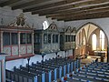
Interior with the three boxes

Baptismal font and Gothic mural in the choir

Single manual organ


.JPG)
Sons and daughters of the church
- Andreas Lembke (1911-2002), microbiologist
Web links
Individual evidence
- ↑ Aasbüttel - Bordesholm . In: Wolfgang Henze (ed.): Schleswig-Holstein topography: cities and villages of the country . 1st edition. tape 1 . Flying-Kiwi-Verl. Junge, Flensburg 2001, ISBN 3-926055-58-8 , p. 181 .
- ^ Federal Statistical Office (ed.): Historical municipality directory for the Federal Republic of Germany. Name, border and key number changes in municipalities, counties and administrative districts from May 27, 1970 to December 31, 1982 . W. Kohlhammer GmbH, Stuttgart / Mainz 1983, ISBN 3-17-003263-1 , p. 183 .
- ^ StBA: Changes in the municipalities in Germany, see 2003
Coordinates: 54 ° 29 ' N , 11 ° 13' E

Albertsdorf | Old age part | Altjellingsdorf | Avendorf | Bannesdorf | Bellevue | Bisdorf | Blieschendorf | Bojendorf | Castle | Castle Depth | Dänschendorf | Dorotheenhof | Fehmarn Sound | Fledged | Gahlendorf | Gammendorf | Gold | Gollendorf | Hinrichsdorf | Johannisberg | Katharinenhof | Klausdorf | Krummensiek | Country Churches | Lemkendorf | Lemkenhafen | Mary's lamp | Matthiasfelde | Meeschendorf | Mittelhof | Mummendorf | New depth | Raised | Neuhof | Neujellingsdorf | Niendorf | Orth | Ostermarkelsdorf | Petersdorf | Presen | Puttgarden | Püttsee | Sahrensdorf | Sartjendorf | Schlagsdorf | Staberdorf | Staberhof | Staberhuk | Strukkamp | Sulsdorf | Teichhof | Teschendorf | Todendorf | Vadersdorf | Vitzdorf | Wallnau | Wenkendorf | Westerbergen | Westermarkelsdorf | Wulfen