
Beinan (Taitung)
|
Beinan 卑南 鄉 |
|||
.svg) Location of Beinans in Taitung County |
|||
| State : |
|
||
| County : | Taitung | ||
| Coordinates : | 22 ° 47 ' N , 121 ° 2' E | ||
| Area : | 412.6871 km² | ||
| Residents : | 6,714 (2017) | ||
| Population density : | 16 inhabitants per km² | ||
| Time zone : | UTC + 8 (Chungyuan time) | ||
| Telephone code : | (+886) (0) 89 | ||
| Postal code : | 962 | ||
| ISO 3166-2 : | TW-TTT | ||
| Community type : | Rural community (鄉, Xiāng ) | ||
| Structure : | 13 villages (村, Cūn ) | ||
| Mayor : | 許 文獻 (Xu Wenxian) ( DPP ) | ||
| Website : | |||
|
|||

Beinan ( Chinese 卑南鄉 , Pinyin Beinan Xiang ) is a rural community in Taitung County on Taiwan ( Republic of China ).
Surname
The name 'Beinan' is said to originally come from the Puyuma language - one of the Formosa languages - to denote an honorary title and to refer to an important chief Pinara . At the time of Dutch colonial rule (1624–1662) the region was known under the name Pimala and under Chinese rule (from 1662) it was given its current name.
Location and landscape
Beinan has an elongated shape and extends from the Pacific coast far inland. The maximum longitudinal extent is approximately 40 kilometers and the associated transverse extent in sections less than 10 kilometers. The country's nature is characterized by mountains and narrow valleys. About 60% of the rural community consists of mountainous land that is largely unpopulated. Climatically (with the exception of the higher mountain regions) there is a warm and humid monsoon climate.
The neighboring parishes of Beinan are: Taitung City in the east, Taimali in the southeast, Jinfeng in the south, Wutai (in Pingtung County ) in the west, Taiping in the north and Donghe in the northeast.
Beinan is further subdivided into 13 villages (村, Cūn ): Binlang (賓朗), Chulu (初鹿), Fushan (富山), Fuyuan (富源), Jiafeng (嘉豐), Liji (利吉), Lijia (利嘉) , Meinong (美 農), Mingfeng (明 峰), Taian (泰安), Taiping (太平), Dongxing (東興) and Wenquan (溫泉). Fushan is located directly on the coastal plain, Liji and Fuyuan are characterized by the southern foothills of the Haian Mountains . Jiafeng, Mingfeng, Meinong, Chulu, Binlang and Taiping overlap with the southern ends of the Huatung Valley , while the topography of Taian, Lijia, Dongxing and Wenquan is entirely determined by the foothills of the Central Taiwan Mountains .
| Outline of Beinan |
|
Liji
利吉 Fuyuan
富源 Fushan
富山 Jiafeng
嘉豐 Taian
泰安 Mingfeng
明 峰 Chulu
初鹿 Meinong
美 農 Binlang
賓朗 Taiping
太平 Lijia
利嘉 Dongxing
東興 Wenquan
溫泉 |

population
Originally the area was settled by members of the Puyuma ethnic group, one of the indigenous peoples of Taiwan . Today the indigenous population (Puyuma, Rukai and Amis ) only make up about a third of the local population and the majority population is made up of Han Chinese, who immigrated to Taiwan since the 17th century. Since the 1970s, the population of the municipality (as well as the population of the entire district) has been decreasing due to rural exodus .
Economy and Infrastructure
The agricultural products produced include coffee , bananas , cinnamon apples , Atemoyas , loquat , rice and guavas . A branch of industry with increasing importance is tourism. The region has many natural attractions, including hot springs, nature reserves, botanical facilities, etc.
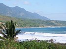
On the coast - in the background the Haian Mountains

Jhihben Hoya Resort - Thermal Bath Hotel

Jhibhen Forest Recreation Area


Web links
Individual evidence
- ↑ a b c Beinan Township. (No longer available online.) Taitung.ogv.tw, archived from the original on November 7, 2017 ; accessed on November 2, 2017 (English).
- ↑ a b 地名 由來 ("Origin of the place name"). Retrieved May 2, 2018 (Chinese).
- ^ Taiwan: Administrative Division. www.citypopulation.de, accessed on November 4, 2017 (English).
- ↑ 農 特 產品. www.beinan.gov.tw, accessed on November 2, 2017 (Chinese).
- ↑ Taiwan's Heavenly Gift in Peril. CommonWealth Magazine (vol. 578), August 7, 2015, accessed November 3, 2017 .