
Mountains of beer
|
Mountains of beer
Municipality Hohenhameln
|
||
|---|---|---|
 |
||
| Height : | 92 m above sea level NHN | |
| Area : | 9.31 km² | |
| Residents : | 841 (December 31, 2018) | |
| Population density : | 90 inhabitants / km² | |
| Incorporation : | March 1, 1974 | |
| Postal code : | 31249 | |
| Area code : | 05128 | |
Location of Bierbergen in Lower Saxony |
||
 View of mountains of beer
|
||

Bierbergen is a district of the municipality of Hohenhameln , Peine district in Lower Saxony . It has 841 inhabitants on an area of 9.31 km² ( as of December 31, 2018 ) .
geography
location
Until a new development area was settled, Bierbergen was a typical clustered village . Until then, shown as an example in the Dierke School Atlas , published to all primary school students. It is located to the east of Hohenhameln in the municipality of Hohenhameln.
Neighboring places
- Hohenhameln
- Saußmar
- New Oedelum
- Oedelum
- Adenstedt
- Groß Solschen
- Klein Solschen
- Stedum
history
First mention
The oldest surviving document that mentions Bierbergen dates back to 1068.
Place name
The old names of the place were in 1151 Bireberge , 1189 Birbergen and 1206 Berberg .
In Old English there is a word "bearo", "bearu" or "forest", which, according to new findings, is likely to be hidden in not a few Lower Saxony place names, such as in Barfelde, Böbber, Deckbergen, Eisbergs near Rinteln or Haimar east of Hanover.
Incorporations
Bierbergen was incorporated into the municipality of Hohenhameln on March 1, 1974 for the regional reform in Lower Saxony .
politics
Local council
The local council of Bierbergen consists of a councilwoman and six councilors from the following parties:
(Status: local election September 11, 2016)
Local mayor
The local mayor of Bierbergen is Dirk Pannicke (SPD). His deputy is Marc-André Delp (CDU).
Culture and sights
Buildings
The Protestant village church, which was completed in 1240, stands on a hill in the middle of the village and is an eye-catcher from the seven roads leading to it. The surrounding wall separates the forecourt, which was used as a cemetery until 1832, from today's village square, in the middle of which a memorial was inaugurated in 1960.
Photo gallery

The Evangelical St. Martin Church in Bierbergen
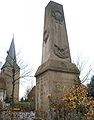
cenotaph


Personalities
Sons and daughters of the place
- August Karl Arnold Michaelis (1847–1916), chemist
Web links
Individual evidence
- ↑ a b c Population and area sizes. In: Website of the community of Hohenhameln. Retrieved October 6, 2019 .
- ^ Jürgen Udolph (research): The "place name researcher". In: website NDR 1 Lower Saxony . Archived from the original on August 17, 2014 ; accessed on August 2, 2019 .
- ^ Federal Statistical Office (ed.): Historical municipality directory for the Federal Republic of Germany. Name, border and key number changes in municipalities, counties and administrative districts from May 27, 1970 to December 31, 1982 . W. Kohlhammer, Stuttgart / Mainz 1983, ISBN 3-17-003263-1 , p. 217 .
- ↑ a b Bierbergen local council. In: Website of the community of Hohenhameln. Retrieved October 6, 2019 .
- ↑ Festschrift: Twenty Years of the Church District of Ölsburg.