
Bonner Strasse (Cologne)
The Bonner Straße is a 5666-meter-long arterial road and radial road by the Cologne districts of Neustadt-Süd , Bayenthal and Marienburg leads.
History and name
It runs from Chlodwigplatz in a southerly direction to the Cologne distribution circle (colloquially known as “Bonn distributor” or “Southern distributor”) at the military ring road ( ![]() ), where it ends. The southern extension of Bonner Strasse is in the
), where it ends. The southern extension of Bonner Strasse is in the ![]() direction of Bonn , which gave Bonner Strasse its name. Severinstrasse forms its northern extension into the city .
direction of Bonn , which gave Bonner Strasse its name. Severinstrasse forms its northern extension into the city .
Just as Aachener Strasse leads to Aachen , Neusser Strasse directs traffic to Neuss , and Venloer Strasse leads to Venlo , traffic on Bonner Strasse leads to Bonn. The street name followed the law of direction, which was included in the naming principles of 1939.
history
The origin of the Bonner Straße goes back to Roman times .
Roman times

Bonner Strasse was built in the 1st century as a Roman major military road ( Latin via militaris Praetoria ). Gravestones of soldiers of the first and twentieth legions of the Cologne winter camp have been preserved from this time, the sites of which were on Bonner Strasse up to Arnoldshöhe (Bonner Strasse No. 120-122, 130, 177). For example, a grave stele of Gaius Messulenus ( released slave ) was found near Bonner Strasse 130 . During Roman times , the Bonner Strasse was a grave road outside the city wall, the extension of the Cardo maximus over the south gate and led south via Bonn ( Latin Bonna ), Koblenz ( Latin Confluentes ) and Mainz ( Latin Mogontiacum ) to Rome .
middle Ages


The Judenbüchel Jewish cemetery (“Am toten Juden”; around 29,000 m 2 in size) was first documented in 1146 and was located at the level of Bischofsweg at the confluence of Brühler Strasse / Raderberger Strasse and Bonner Strasse. In 1163 "Cathars" (heretics) were burned there. At the latest since 1463 there was also an infirmary at the Judenbüchel, and in 1697 two Cologne citizens had a chapel built there. When the new Archbishop of Cologne, Hermann IV of Hesse , officially entered, around 400 mounted citizens and 1,350 horsemen of the archbishop's retinue came together at the turnpike on February 17, 1488.
On Arnold Mercator's view of the Cologne city from 1570 , the area around "Bonnische Straiß" was exclusively for agricultural cultivation. It was still called that in September 1690 when a map showed lively traffic here. The Schweidkarte of Abraham Hogenberg Although from 1609 recorded the Bonner Straße, but not mentioned her name.
Founding period

The map by Jean Joseph Tranchot from 1807/1808 shows it as the “Grand Route de Bonn” with the “Dead Jew”. This is also the name of the “ Itinéraire de Cologne ” published in January 1813 by Ferdinand Franz Wallraf , the only Cologne address book in French. A map from 1874 recorded it as "Chausee von Bonn". When the Neustadt Süd was expanded, Bonner Strasse became Torstrasse, as it led to what was then the “Bonner Tor” in the outer city wall. The Bonner Tor was part of the fortress ring of Cologne , begun in April 1815 , where Fort II ("Grand Duke Nicholas of Russia") was built between November 1816 and December 1821 at Marktstrasse. The “Bonner Tor” ( Bunre portze ) was one of originally twelve city tower gates, originally three-storey with pointed arch portals, simply tiered, its passage had groin vaults. In its place is now the Cologne wholesale market . Fort III (Bonn Wall No. 108–110), which also no longer exists today, was built between 1843 and 1847.
The Leybold GmbH in No. 498 began in May 1851 with Ernst Leybold (1824–1907) as co-partner of "Leybold & Kothe" and specialized in vacuum technology. In February 1868, Leybold acquired an area of around 60 hectares with a manor house and estate in the Cologne-Marienburg villa colony, which was later built and whose fields stretched as far as Bonner Strasse, from the Sal. Oppenheim bank . In 1869, the entrepreneur Carl Friedrich Mann acquired land on both sides of Bonner and Brühler Strasse and had houses built there. He named the area with the Villa Lenders , built in 1876 , Mannsfeld , which in 1945 merged into the Bayenthal and Raderberg districts. From the former Bayenthal cemetery in Arnoldshöhe from 1876, only the renovated Hochkreuz remains; its occupancy ended in 1914.
Bonner Strasse was given its current street name on May 10, 1883, and it was not until December 20, 1883 that the city council named Chlodwigplatz as the southernmost part of the Cologne rings . The city council named the Sternplatz on Bonner Strasse, at the height of Elsaßstrasse and Kurfürstenstrasse, in Bonner Platz on August 14, 1884. In 1878 a steam brewery was built at No. 324 by the brewer Joseph Stauff.

Bonner Straße 304a-e - Wilhelmsruh workers' settlement (1889)

Bonner Strasse 15-17
Bonner Strasse 41 (1903)

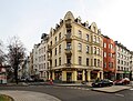
Bonner Strasse 64 (around 1890)

Bonner Strasse 262–264
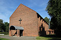
Bonner Strasse 549 (All Saints Church, 1951)
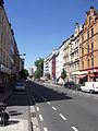
Bonner Strasse - View of Chlodwigplatz and Severinstor (June 2011)


Construction of the “Arbeiter-Colonie Wilhelmsruh” began on March 24, 1888, built by Gerhard vom Rath . The floor plan of the estate with 33 houses in seven groups of houses (Bonner Strasse No. 304a-e and 310a-r) is rectangular and is delimited by Bonner Strasse and Rheinsteinstrasse. 900 tenants lived on an area of 4.5 hectares. Most of the residential buildings were built on Bonner Strasse between 1890 and 1904, for example the house at no. 64. On August 10, 1899, the Cologne-Bonntor freight yard , part of the Cologne freight bypass , opened on Bonner Strasse in 1980. The Stollwerck brothers built houses on Bonner Strasse / Gürtel until 1902 for the masters of their company ("Frieden" settlement). There were six villa-like houses for 40 families with the names of a "deserving master" such as "Villa Dellbrouck".
Modern times
On July 22, 1909, the Wilhelmsruh workers' settlement was transferred to the city of Cologne. At the corner of Gaedestrasse, the Arnoldshöhe barracks, built in 1911, moved into. The Cologne gymnastics club from 1843 had to give up its sports facility on the corner of the military ring road and the corner of Bonner road in 1919 because of the construction planning for the Cologne-Bonn motorway . Construction of the oldest German motorway began in October 1928 and was inaugurated on August 6, 1932 by the mayor of Cologne, Konrad Adenauer . That is why it was not Adolf Hitler , as the later Nazi propaganda reported , but Adenauer who had the first motorway built. Formally it was known as “Kraftwagenstrasse” and was called “Landstrasse 185” as the southern extension of Bonner Strasse. A “Police Ordinance on the Use and Expansion of Motor Vehicle Road Cologne - Bonn” of August 2, 1932, which came into force specifically for this purpose, stipulated that the 12 meter wide and 18.5 kilometer long road should only be reserved for motor vehicles. Only in April 1959 was it formally classified as a federal motorway .
Because of the construction work on the Bonntor freight station, the excavations of the Judenbüchel in the Jewish cemetery on Venloer Straße have been reburied since 1922 . Between 1921 and 1923, a block of flats for the British occupation forces was built in No. 537-545. The former farm buildings of the Arnoldshöhe barracks were converted into a home for men in need of relaxation and opened as the Arnoldshöhe single home (100 beds) in October 1927. On December 15, 1951 the inauguration of the All Saints Church ( English All Saints Church ) of the Anglican Episcopal Church Community Cologne / Bonn in No. 549 took place.
In November 2013, the city of Cologne acquired the 15.2 hectare site of the former Cologne-Bonntor freight yard. Villa Lenders, which belongs to the city of Cologne, had to give way to the construction of the north-south light rail in March 2018 . On this north-south light rail, construction work began in January 2009 for the second construction phase between Bonn Wall and the Rhine. In December 2015, the southern section of the north-south light rail went into operation from Severinstraße underground station . Line 17, which runs there, runs from Severinstrasse via the Bonner Wall stop and the second construction section to the Rheinuferbahn line and ends in Rodenkirchen or Sürth . The north-south tram will be extended from the Marktstrasse stop via Bonner Strasse to the southern distribution circle, where tram line 16 will run in the future.
Important intersections or cross streets of Bonner Strasse are Zugweg / Kurfürstenstrasse, Teutoburger Strasse / Rolandstrasse, Schönhauser Strasse / Marktstrasse with the wholesale market in Cologne , Brühler Strasse and Lindenallee (connection to the Cologne-Marienburg villa colony ) and the Bayenthal belt / Raderberg belt.
There is another Bonner Straße in the Cologne city area in Cologne-Porz .
See also
- List of architectural monuments in the Bayenthal district of Cologne
- List of architectural monuments in the Marienburg district of Cologne
Web links
Individual evidence
- ^ Marion Werner, From Adolf-Hitler-Platz to Ebertplatz , 2008, p. 236 f.
- ↑ Naming principles, 1939, § 3 f, (4) to (5)
- ^ Geographical Institute of the University of Cologne (ed.), Kölner geographischearbeiten , edition 82, 2004, p. 75
- ↑ Winfried Reinhardt, History of Cologne Transport: 3000 Years of Mobility in the Rhineland , 2017, p. 60
- ↑ Elfi Pracht-Jörns, Jüdisches Kulturerbe in Nordrhein-Westfalen , 1997, p. 281
- ↑ Elfi Pracht-Jörns, Jewish cultural heritage in North Rhine-Westphalia , 1997, p. 282
- ↑ Historisches Archiv (ed.), Ad summum 1248 , 1998, p. 117
- ↑ Nordrhein-Westfälisches Hauptstaatsarchiv (Hrsg.), Kurkoeln, Land under the crook: Essays and documents , 1985, p. 376
- ↑ Fred Kaufmann / Dagmar Lutz / Gudrun Schmidt-Esters, Cologne street names: Neustadt and Deutz , 1996, p. 37
- ↑ Hans Rothkamp, Alt-Brühl and his neighbors , 2011, p. 98
- ↑ Udo Mainzer, Stadttore im Rheinland , 1976, p. 255
- ↑ Hiltrud Kier / Wolfram Hagspiel / Dorothea Heiermann / Ulrich Krings, Stadtspuren, Denkmäler in Köln , Volume 1-Volume 8, 1996, p. XVIII
- ^ Heinrich Böll / Árpád Bernáth, Works: Cologne Edition , Volume 14, 2002, p. 755
- ↑ Fred Kaufmann / Dagmar Lutz / Gudrun Schmidt-Esters, Cologne street names: Neustadt and Deutz , 1996, p. 38
- ↑ Fred Kaufmann / Dagmar Lutz / Gudrun Schmidt-Esters, Cologne street names: Neustadt and Deutz , 1996, p. 38
- ↑ Historical Archive (ed.), Zeugen Kölner Brau-Kultur , 1396–1996, 1996, p. 128 f.
- ↑ Chronik Verlag (ed.), Chronik Köln , 1997, p. 292
- ^ Hiltrud Kier / Ulrich Krings, Stadtspuren, Denkmäler in Köln , Volume 1; Volume 10, 1988, p. 22
- ↑ Peter Fuchs (ed.), Chronik zur Geschichte der Stadt Köln , Volume 2, 1991, p. 167
- ^ Albert Soboul, The Great French Revolution , 1977, p. 306
- ↑ Matthias Pesch: The north-south railway should start rolling in mid-2016 . In: Kölner Stadt-Anzeiger , May 2, 2013, accessed on June 1, 2013
Coordinates: 50 ° 55 ′ 9.9 " N , 6 ° 57 ′ 35.8" E