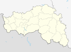
Borisovka (Belgorod)
| Urban-type settlement
Borisovka
Borisovka
|
||||||||||||||||||||||||||||||||||
|
||||||||||||||||||||||||||||||||||
|
||||||||||||||||||||||||||||||||||
| List of large settlements in Russia | ||||||||||||||||||||||||||||||||||
Borissowka ( Russian Бори́совка ) is an urban-type settlement in Belgorod Oblast ( Russia ) with 13,896 inhabitants (as of October 14, 2010).
geography
The settlement is located about 40 kilometers as the crow flies west of the Belgorod Oblast Administrative Center , on the left Dnepr tributary Worskla .
Borissowka is the administrative center of the Borissowka Rajon of the same name .
The forest on the Worskla , part of the Belogorje nature reserve, extends northeast of the settlement .
history
The place was first mentioned in 1695. In 1705 the place and the surrounding lands came into the possession of the Count and Field Marshal General of the Russian Army in the Great Northern War Boris Sheremetev . By the middle of the 19th century, it had developed into an important local economic center with over 50 handicraft businesses, the population of which exceeded today's.
In 1928 Borissovka, which had previously belonged to Ujesd Chotmyshsk , then to Ujesd Graivoron until 1838 , became the administrative center of a raion of the same name, which also included the now insignificant Khotmyshsk, 15 kilometers to the west, which lost its city rights.
During the Second World War , the place was occupied by the German Wehrmacht from October 1941 to early August 1943 .
In 1959, Borissovka received urban-type settlement status.
Population development
| year | Residents |
|---|---|
| 1877 | 17,502 |
| 1939 | 8,965 |
| 1959 | 10,386 |
| 1970 | 11,839 |
| 1979 | 12,411 |
| 1989 | 13.002 |
| 2002 | 14,072 |
| 2010 | 13,896 |
Note: from 1939 census data
Economy and Infrastructure
In Borisovka there are companies in the food and construction industries, as well as a ceramic factory.
Eight kilometers west of the town, near the village of Belenkoje, is the Novoborissovka station on the railway line that connects Lgov via Proletarsky ( Gotnja station ) with Kharkiv in the Ukraine . The regional road R 186 runs through the village , which leads from Belgorod to Graiworon and to the Ukrainian border in the direction of Ochtyrka , which is almost 40 km away .
Sons and daughters of the place
- Stepan Degtjarjow (1766–1813), composer
- Gawriil Lomakin (1812-1885), composer
- Pavlo Barvinsky (1862–1908), Ukrainian actor and playwright
Individual evidence
- ↑ a b Itogi Vserossijskoj perepisi naselenija 2010 goda. Tom 1. Čislennostʹ i razmeščenie naselenija (Results of the All-Russian Census 2010. Volume 1. Number and distribution of the population). Tables 5 , pp. 12-209; 11 , pp. 312–979 (download from the website of the Federal Service for State Statistics of the Russian Federation)
Web links
- Borisovka on the Oblast Administration website (Russian)


