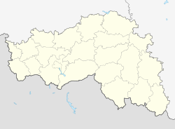
Severny (Belgorod)
| Urban-type settlement
Severny
Северный
|
||||||||||||||||||||||||||||||
|
||||||||||||||||||||||||||||||
|
||||||||||||||||||||||||||||||
Severny ( Russian Се́верный ) is an urban-type settlement in the Belgorod Oblast in Russia with 9,847 inhabitants (as of October 14, 2010).
geography
The settlement is a suburb of the Belgorod Oblast Administrative Center and is about 10 km as the crow flies north of the city center and about 2 km from the outskirts.
Severny belongs to the Belgorodski Rajons , whose administrative seat Maiski is almost 20 km south on the opposite side of Belgorod, and is the seat and only locality of the municipality (gorodskoje posselenije) Possjolok Severny.
history
The village was founded in 1947, as the first one there buildings belonging to the surrounding villages Jerik, Oskotschnoje and ski Chino state farm were built. In the settlement initially named Ostrowok , the first single-family houses were built in 1952 and a first elementary school in 1958. In 1956 a cattle production company (for meat and milk) was opened and the settlement was subsequently referred to as Sagotskototkorm (from Russian sagotskot as an abbreviation for “ animal production ” and otkorm for “ fattening ”).
The settlement has had its current name since 1968, from Russian sewer for "north", meaning "northern settlement", in reference to its location in Belgorod. From the beginning of the 1980s, prefabricated buildings were erected on a larger scale and before 1989 the status of an urban-type settlement was given.
Population development
| year | Residents |
|---|---|
| 1989 | 3678 |
| 2002 | 7654 |
| 2010 | 9847 |
Note: census data
traffic
The original route of the M2 Crimean federal trunk road (part of European route 105 ) runs through Severny from Moscow via Kursk and Belgorod to the Ukrainian border (from there in the direction of Kharkiv - Zaporizhia - Crimea ), today the northern arterial road from Belgorod. A few kilometers to the north, the extensive western bypass of Belgorod branches off, which is now designated as M2. To the south, the inner ring around the city crosses the arterial road between the city limits of Belgorod and Severny.
The closest larger train station is Belgorod on the Moscow - Kursk - Kharkiv line, while the smaller Belomestnaja and Schopino stations are only 5 to 6 km east and northeast on the same line.
Web links
Individual evidence
- ↑ a b Itogi Vserossijskoj perepisi naselenija 2010 goda. Tom 1. Čislennostʹ i razmeščenie naselenija (Results of the All-Russian Census 2010. Volume 1. Number and distribution of the population). Tables 5 , pp. 12-209; 11 , pp. 312–979 (download from the website of the Federal Service for State Statistics of the Russian Federation)

