Borsja (river)
|
Borzya Borzya |
||
|
|
||
| Data | ||
| Water code | RU : 20030100312118100006612 | |
| location | Transbaikalia Region ( Russia ) | |
| River system | Amur | |
| Drain over | Onon → Shilka → Amur → Tatar Sound | |
| source |
Kukulbei Mountains 51 ° 4 ′ 22 ″ N , 117 ° 19 ′ 52 ″ E |
|
| Source height | 890 m | |
| muzzle |
Onon Coordinates: 50 ° 37 '49 " N , 115 ° 39' 43" E 50 ° 37 '49 " N , 115 ° 39' 43" E |
|
| Mouth height | 580 m | |
| Height difference | 310 m | |
| Bottom slope | 1 ‰ | |
| length | 304 km | |
| Catchment area | 7080 km² | |
| Medium-sized cities | Borsja | |
|
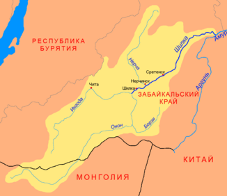
Location of the Borsja (Борзя) in the catchment area of the Shilka |
||
The Borsja ( Russian Борзя ) is a 304 km long right tributary of the Onon in Transbaikalia ( Russia , Asia ).
course
The actual Borsja arises at an altitude of almost 900 m near the village Onon-Borsja on the southern flank of the Kukulbei Mountains, which run parallel to the Borschtschowotschny Mountains, from the source brooks Sakljutschnaja Borsja from the right and Saretschnaja Borsja from the left. Both are less than 10 kilometers long and arise in the ridges of the mountain range at an altitude of 1100 to 1200 meters. The Borsja flows in primarily south-westerly directions in a wide, partly swampy valley through the relatively dry steppes of Transbaikaliens (Dauriens). In the lower reaches it turns to the north and finally flows into the Onon, one of the headwaters of the Amur , at an altitude of 580 m north of the village of Ust-Borsja . Near the mouth, the Borsja is almost 30 meters wide, a good one meter deep, and the flow rate is 0.4 m / s.
The Borsja has no significant tributaries. On its entire course it flows through the Transbaikalia region .
Hydrography
The catchment area of the Borsja covers 7080 km². The Borsja partially freezes to the bottom between mid-November and early April. In the summer months, after heavy rainfall, floods occur, while in dry years the river can dry out. The mean water flow is 2.8 m³ / s.
Infrastructure
The Borsja is not navigable.
The only larger town on the middle course is the town of Borsja, named after the river . Here the river is crossed by the railway line that leads from the Karymskaja station on the Trans-Siberian Railway across the border at Sabaikalsk to the People's Republic of China (originally the Chinese Eastern Railway and the main line of the Trans-Siberian). The A166 trunk road following the railway line also crosses the river near Borsja. The rest of the area through which the water flows is also relatively well developed by roads: the river is crossed by road bridges in several places; the regional road R430 Nerchinsky Zavod -Borsja- Solowjowsk (border to Mongolia ) follows the middle and upper reaches of the river on long distances.
