
Bottini di Siena
The Bottini di Siena are a medieval canal system and an underground aqueduct for the water supply of the city of Siena with a total length of 25 km. The system was active as the main water supply for Siena until the 1910s and continues to supply water to the fountains of Siena to this day.

description

It is named after the botte (Italian for barrels ), which describes the shape of the arched walls and roofs of the canals and tunnels , mostly made of terracotta . The underground canal system of the Bottini (singular Bottino ) consists of several waterways that, with a few exceptions, supply the wells within the city walls of Siena or the wells a few meters outside and are fed from water sources located within the city walls and several kilometers outside the city walls become. The Bottini collect rainwater between two differently permeable rock banks and lead it into the city, as the city of Siena is based on three hills and is only located on a few rivers that pass relatively far from the center of the village, such as. B. the river Tressa in the southwest and south of the city as the closest river to the city of Siena. Other reasons for setting up a system that supplied water to wells were, in addition to the drinking water supply for the population, fire protection, the supply of water- dependent craft businesses ( dyers , leather makers ), the water supply for animals, the supply of wash houses and the irrigation of agriculture.
The Bottini are not to be seen as a uniform canal system. In addition to the main veins Bottino maestro di Fonte Gaia and Bottino maestro di Fontebranda and their side arms ( called Ramo , plural rami ) there are many independent Bottini that only feed individual wells. The watercourses are not identical to the streets of Siena. Most of the canals ( called Gorello , plural: gorelli ) have a width of about 20 to 30 centimeters and are mostly in brick-walled corridors that are about 50 to 90 centimeters wide. The height of the corridors varies from 1.50 to 2 meters. The Bottini are not closed off from the outside world, there are several air shafts in each Bottino ( called smiraglio , pl .: smiragli , sometimes also called occhio , pl .: occhi ).
The Bottino maestro di Fonte Gaia is fed by the three main tributaries from Colombaio (also del Castagno , at 5.75 km the most distant point north of Fonte Gaia), Michele a Quarto (also San Dalmazio ) and Uopini , which are near the fountain of Fontebecci come together. Smaller tributaries are that of Vico Alto (before Fontebecci in the Ramo di Colombaio) and those of Acqua Calda , Marciano and Poggiarello (between Fontebecci and Porta Camollia ). The entire route has a constant gradient ( gradient ) of 1 ‰ (1 m gradient over 1 km in length) and transports 2.7 liters per second. The excavations took place from two different points. On the one hand from the Piazza del Campo to the north, on the other hand from Santa Petronilla (near the Antiporto di Camollia ), in the direction of Fonte Gaia (south) and in the direction of Fontebecci (north).
The Bottino maestro di Fontebranda is the shorter (most distant point 3.8 km north of Fontebranda), but older and also deeper of the two main canals. It also rises north of the city walls and transports 3.5 liters per second. Excavations here always went north from the well itself. The most important tributary is the Ramo di Chiarenna . Other important tributaries are those of Santa Petronilla and San Prospero .
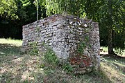
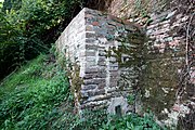
history
_(14590733658).jpg)
_(14754353596).jpg)
The first underground watercourses already existed in the 4th century, when Siena was still limited to the area of Castelvecchio. The Fontanella fountain is mentioned here in 394. The search for the subterranean river Diana mentioned by Dante Alighieri in the Divine Comedy has not yet been successful. The reason for the construction of the aqueducts in the Middle Ages was the scarcity of water in the city of Siena, which experienced a strong population growth in the 11th century. As the closest river to Siena, the Tressa often had little water, so that the grain for Siena had to be ground at the mills of the Merse ( Molino del Pero and Molino del Palazzo ) near Brenna .
They were first documented as Bottini in 1226 as Buctinus . Brick Bottini were documented in 1246 during expansion work by Fontebranda, when " thousands of stones " were used. Further work on the tributaries to the fountains took place in March 1250, here work was carried out on the fountains of Val di Montone, Follonica, Fontebranda, Pescaia and Vetrice, with that of Pescaia on the two main arms (Bottino di Fontegaia and Bottino di Fontebranda) connected. In 1267 there were attempts to divert the waters of the Merse to Siena, but these plans failed shortly afterwards. Then the focus was again on repairing the existing waterways. New water veins were found in 1274, which later led to the construction of the Fontenuova and Fonte d'Ovile fountains. In order to finally lead the water to the central Piazza del Campo, the city government accepted Jacopo di Vanni di Ugolino's proposal on December 16, 1334, to use water from the northern zones of Siena over the 1.5 m high that was still to be built and 0.75 m wide planned Bottino maestro di Fonte Gaia . The planned construction period of three years could not be met until 1346 only the well Fontebecci was reached, with water discharged from the Staggia should be supplied. For the difficult parts of the excavations , miners from Massa Marittima and Montieri , called Guerchi , were employed from 1341 , who received higher wages than the inexperienced Senese workers. The first stones for the construction of the Fonte Gaia were laid in April 1343, the fountain was consecrated in 1346 (with the water coming from Fontebecci) and then redesigned from 1409 to 1419 by Jacopo della Quercia . The Ramo di Uopini was completed in 1387. In order to increase the water quality, the Galazzoni were built under the Prato di Porta Camollia in 1437/1438 , a system that removes the lime from the water by decanting . These basins are 1.60 m deep and hold at least 1400 hl . No significant changes or extensions were made after 1466.


The first private branches to private households emerged from 1474 onwards. On July 14, 1474, Alessandro di Mariano Sozzini received permission from the city government to build a drain near the Pantaneto fountain to his private house in Via Pantaneto at his own expense. In September of the same year Pietro Forteguerri also received permission to draw water from the fountain in Via del Casato to his house. Bartolo di Tura also received permission in 1474 to create a private connection. The aim of creating private connections was to reduce illegal discharges, the immense extent of which was officially established as early as 1446. From September 1691 , the drains to private households were equipped with dadi (singular: dado , also called forellino (small hole)) in order to divert the desired amount of water and to bill the household accordingly. Common dimensions were from half a dado to three and a half dadi. One dado was equivalent to 400 liters of water a day. The air shafts ( smiragli ) outside the city walls proved to be problematic in times of war . Already in the run-up to the Battle of Camollia (1526), the conspirator Lucio Aringhieri tried to bring troops into the city via the Bottini. In the run-up to the Fiorentine siege (1554–1555), the Bottini began to be walled up in March 1553 so that only water could flow under the barriers.
- Shafts (smiragli)
Shaft (smiraglio) near San Benedetto (Acquacalda district), part of the Bottino di Fonte Gaia
Shaft (smiraglio) of the Bottino di Fonte Nuova between Porta Camollia and the Barriera San Lorenzo (Le Lupe) on the outer side of the northern city walls of Siena

Shaft at the drainage canal after the Fontebranda fountain, below and inside the city wall


The oldest planimetric map still in existence dates from 1739 and is now in the Siena State Archives. In July 1825 Giovanni Gani established a connection between the two main canals at an intersection near the Palazzo dei Diavioli. In order to supply water to the almost dry canal of Fontegaia, it was taken with two pumps from the canal of Fontebranda, located twenty meters below. After the water flow in the Bottino of Fontegaia normalized, the connection was interrupted again in the same year. This system was used in 1835 and 1851 for the same reasons. In order to cope with the water shortage in the Fontegaia Canal, restoration work took place from 1851 to 1868, during which several areas of the canal affected by landslides were cleared. The procedure with (modernized) pumps was resumed in 1870 when steam pumps were installed at Vico Bello. However, these were moved in the direction of the road to San Domenico as early as 1873; the length of the connecting pipe is given as 31 m. This connection also supplied the area around Fortezza Santa Barbara and was active until 1931.
The end of the Bottini as part of the drinking water supply

At the end of the 19th century, the water supply via the Bottini was no longer considered to be sufficient in quantitative and hygienic terms. From 1885 18 springs were examined, from 1886 the rivers Arbia , Elsa and Masellone, as well as Bozzone (river) , Staggia and Tressa, which were less than 10 km away from the city, were shortlisted to determine whether they corresponded to the water quality for city supply. Ultimately, in 1895 the choice fell on the Vivo , which rises on Monte Amiata . From just below the source at Vivo d'Orcia to Siena, an underground aqueduct called Acquedotto del Vivo was built through the municipal areas of Castiglione d'Orcia , Montalcino , San Quirico d'Orcia (near Bagno Vignoni ) and Murlo , which is called Acquedotto del Vivo and continues to this day , in addition to later supply lines (for example the water of the rivers Ente and Fiora ), which supplied the city of Siena with drinking water. The aqueduct reached Porta San Marco in 1914, the inner-city distribution system was completed in 1918.
Fountain
The wells that belong to the Bottini water system are divided into two categories. The main wells ( fonti maggiori ) include wells that have larger water inlets, the secondary wells ( fonti minori ) include wells whose water quantity and importance is much lower.
Main well
| Surname | Location | Above sea level | annotation | image |
|---|---|---|---|---|
| Fonte Gaia |
Piazza del Campo 43 ° 19 ′ 7 ″ N, 11 ° 19 ′ 53 ″ E |
321 m slm | Main well, is fed by the Bottino maestro di Fonte Gaia . |
_02.jpg)
|
| Fontebranda | Via Fontebranda 43 ° 19 ′ 10 ″ N, 11 ° 19 ′ 40 ″ E |
292 m slm | Main fountain of the Bottino maestro di Fontebranda , eponymous for the city gate Porta Fontebranda . First mentioned in 1081. Is the contrada fountain of the Contrada Oca. |

|
| Fontebecci | SS 222 43 ° 20 ′ 36 ″ N, 11 ° 18 ′ 21 ″ E |
combines the three side channels of the Bottino maestro di Fonte Gaia . |

|
|
| Fonte del Casato | Via del Casato (di Sotto) / Vicolo della Fonte 43 ° 19 ′ 0 ″ N, 11 ° 19 ′ 52 ″ E |
319 m slm | Also called Fonte Serena . Is fed by the extension of the Bottino maestro di Fonte Gaia to the Fonte Gaia. |

|
| Fonte di Follonica | Follonica Valley 43 ° 19 ′ 10 ″ N, 11 ° 20 ′ 14 ″ E |
275 m slm | First mentioned fountain in 1226. |

|
| Fonte di Fontanella | Via di Fontanella 43 ° 18 ′ 54 ″ N, 11 ° 19 ′ 57 ″ E |
311 m slm | Is fed by its own Bottino, which is approx. 300 m long and delivers 0.2 liters per second. |

|
| Fontenuova | Via Pian d'Ovile / Via Fonte Nuova 43 ° 19 ′ 23 ″ N, 11 ° 19 ′ 50 ″ E |
304 m slm | Also called Fonte Nuova or Fonte Nuova d'Ovile . The fountain is located within the city walls near the Porta Ovile and was built between 1303 and 1323. It is fed by an independent Bottino, which extends 807.50 m to the northwest and leaves the city walls underground. The first 437 m are bricked, the remaining meters lead through dug ground. The Bottino delivers 1.0 liters per second. It is the contrada fountain of the Contrada Lupa. |

|
| Fonte d'Ovile | Via Simone Martini 43 ° 19 ′ 26 ″ N, 11 ° 20 ′ 3 ″ E |
277 m slm | The fountain is located outside the Porta Ovile city gate and is fed by its own bottino, which delivers 1.3 liters per second. |

|
| Fonte di Pescaia | Strada delle Fonti di Pescaia 43 ° 19 ′ 32 "N, 11 ° 19 ′ 22" E |
304 m slm | Also called Fonti di Pescaia . The fountain is outside the city walls. Today it houses the Museo dell'Acqua . |

|
Secondary fountain
| Surname | Location | Above sea level | annotation | image |
|---|---|---|---|---|
| Fontegiusta | Vicolo di Malizia 43 ° 19 ′ 31 "N, 11 ° 19 ′ 36" E |
Today only available as an entrance to the Bottino maestro di Fonte Gaia . |

|
|
| Fonte delle Monache | Via delle Sperandie 43 ° 18 ′ 41 ″ N, 11 ° 19 ′ 41 ″ E |
Also known as Fonte delle Monache di San Paolo and Fonte delle Suore Benedettine di Sant'Agnese . Is fed by its own Bottino. |

|
|
| Fonte di Pantaneto | Via Pantaneto 43 ° 19 ′ 7 ″ N, 11 ° 20 ′ 2 ″ E |
Is fed by the extension of the Bottino maestro di Fonte Gaia to the Fonte Gaia. Was created in 1452 or 1457 and was redesigned by Serafino Belli in 1807. It is the contrada fountain of the Contrada Leocorno. |

|
|
| Fonte al Pino | Botanical Garden (Orto botanico) 43 ° 18 ′ 46 ″ N, 11 ° 19 ′ 49 ″ E |
297 m slm | Also Fonte dell'Orto Botanico , Fonte di Valle Berardi . The fountain is located within the city walls near the Porta Tufi in what is now the botanical garden of the University of Siena and is fed by an independent and dug Bottino. It is first mentioned in 1231. |

|
| Fonte dei Pispini | Via dei Pispini 43 ° 19 ′ 4 ″ N, 11 ° 20 ′ 24 ″ E |
Originated in the 13th century and redesigned in 1534. Is fed by the extension of the Bottino maestro di Fonte Gaia to the Fonte Gaia. It is the contrada fountain of the Contrada Nicchio. |
_(14777012102).jpg)
|
|
| Fonte di Samoreci | Via San Girolamo 43 ° 19 ′ 1 ″ N, 11 ° 20 ′ 15 ″ E |
Also called Fonte di Ponte di Romana or Fonte di San Maurizio . Is fed by the extension of the Bottino maestro di Fonte Gaia to the Fonte Gaia and was connected in 1351. It is the contrada fountain of the Contrada Montone. |

|
|
| Fonti di San Carlo | Strada di San Carlo 43 ° 18 ′ 27 ″ N, 11 ° 19 ′ 5 ″ E |
Fountain outside the Porta San Marco . Is fed by its own Bottino, which delivers 0.8 liters per second. |

|
|
| Fonte di San Francesco | Via Rossi / Via del Comune 43 ° 19 ′ 19 ″ N, 11 ° 19 ′ 59 ″ E |
Is fed by a derivative from the Bottino maestro di Fonte Gaia . The name comes from the nearby Basilica di San Francesco , but is also called Fonte di San Bernardino. Includes the statue of Francesco d'Agnolo ( called Barbicone ) by Angelo Canevari. He is the contrada fountain of the Contrada Bruco. |
.jpg)
|
|
| Fonte delle Sperandie | Via del Nuovo Asilo 43 ° 18 ′ 49 ″ N, 11 ° 19 ′ 32 ″ E |
Fountain outside the city gates of Porta San Marco and Porta Laterina. Was mentioned in 1330. |
_(14797229953).jpg)
|
|
| Fonte dei Tufi | Via di Fontanella 43 ° 18 ′ 44 ″ N, 11 ° 20 ′ 3 ″ E (approx.) |
also called Fonte dei Caccialupi , near the Porta Tufi . Lies in a grotto and is fed by its own 120 m long Bottino, which is equipped with two 50 m long side arms. Made at the end of the 16th century. | ||
| Fonte della Vetrice | approx.Via del Fosso di Sant'Ansano 43 ° 18 ′ 59 ″ N, 11 ° 19 ′ 38 ″ E (approx.) |
No longer available, mentioned in 1081. |
literature
- Antonio Maria Baldi: Gli antichi bottini senesi. In: Leonardo Lombardi, Gioacchino Lena, Giulio Pazzagli (eds.): Tecnica di idraulica antica. Geologia dell'Ambiente, Supplemento al numero 4/2006 (Periodico della SIGEA, Società Italiana di Geologia Ambientale), Rome 2006 ( online edition , PDF)
- Comune di Siena (ed.): I Bottini. Acquedotti medievali senesi . Edizioni Gielle, Siena 1984
- Comune di Siena, Santa Maria della Scala, Associazione La Diana (ed.): A ritrovar la Diana. Protagon Editori, Siena 2001, ISBN 88-8024-074-9
- Duccio Balestracci, Laura Vigni, Armando Constantini: La memoria dell'Acqua. I bottini di Siena. Protagon Editori, Siena 2006
- Acquedotto del Fiora / La Diana (ed.); Benedetto Bargagli Petrucci, Giacomo Luchini, Luca Luchini, Laura Vigni, Giacomo Zanibelli: Acqua per la città. Nel centenario dell'acquedotto del Vivo. Una tormentata avventura senese fra XIX e XX secolo. Tipografia senese, Siena 2014
- Fabio Bargagli Petrucci: Le fonti di Siena ei loro aquedotti, note storiche dalle origini fino al MDLV. Siena 1906 ( online edition at archive.org , PDF)
Web links
- Official website of the city of Siena for the Bottini di Siena.
- La Diana , Associazione La Diana, website for the Bottini di Siena.
- Website of the Museo dell'Acqua
- Enjoy Siena , website of the municipality of Siena about the Bottini di Siena.
- Enjoy Siena , website of the municipality of Siena on the Museo dell'Acqua.
- Bottini medievali senesi
- La mia terra di Siena: Fonti e bottini di Siena
Individual evidence
- ↑ a b c d Comune di Siena (ed.): I Bottini. Acquedotti medievali senesi . P. 20.
- ↑ a b c Official website of the city of Siena on the Bottini di Siena, accessed on October 18, 2018 (Italian)
- ^ Fabio Bargagli Petrucci: Le fonti di Siena ei loro aquedotti, note storiche dalle origini fino al MDLV. P. 17.
- ↑ Comune di Siena (ed.): I Bottini. Acquedotti medievali senesi . P. 13.
- ^ Duccio Balestracci, Laura Vigni, Armando Constantini: La memoria dell'Acqua. I bottini di Siena. P. 44.
- ↑ a b c d Antonio Maria Baldi: Gli antichi bottini senesi.
- ^ Duccio Balestracci, Laura Vigni, Armando Constantini: La memoria dell'Acqua. I bottini di Siena. Pp. 58 and 62.
- ↑ a b Comune di Siena (ed.): I Bottini. Acquedotti medievali senesi . P. 37.
- ↑ Comune di Siena, Santa Maria della Scala, Associazione La Diana (ed.): A ritrovar la Diana. P. 13.
- ^ Duccio Balestracci, Laura Vigni, Armando Constantini: La memoria dell'Acqua. I bottini di Siena. P. 36.
- ↑ a b c d e f Duccio Balestracci, Laura Vigni, Armando Constantini: La memoria dell'Acqua. I bottini di Siena. P. 92.
- ↑ a b c d e f Associazione La Diana: I bottini di Siena , accessed on October 17, 2018 (Italian)
- ↑ Comune di Siena (ed.): I Bottini. Acquedotti medievali senesi . P. 44 ff.
- ↑ a b c Comune di Siena (ed.): I Bottini. Acquedotti medievali senesi . P. 15
- ↑ Tu li vedrai tra quella gente vana, che spera in Talamone , e perderagli più di speranza ch'a trovar la Diana; ma più vi perderanno li ammiragli. ( Dante Alighieri, Divina Commedia, Purgatorio, XIII, 151–154, it.wikisource ), You will find mine among the vain people, the talamon tempts to delusional hope; And as with Diana's source it will dwindle - But the admirals put more on it. Streckfuß translation 1876 Divine Comedy (Streckfuß 1876), Purgatorio, de.wikisource
- ↑ Comune di Siena (ed.): I Bottini. Acquedotti medievali senesi . P. 10.
- ↑ a b c d Comune di Siena (ed.): I Bottini. Acquedotti medievali senesi . P. 19.
- ↑ a b c Comune di Siena (ed.): I Bottini. Acquedotti medievali senesi . P. 17.
- ^ A b Duccio Balestracci, Laura Vigni, Armando Constantini: La memoria dell'Acqua. I bottini di Siena. P. 26.
- ^ Duccio Balestracci, Laura Vigni, Armando Constantini: La memoria dell'Acqua. I bottini di Siena. P. 29.
- ↑ Coming from the German word Werker: Fabio Bargagli Petrucci: Le fonti di Siena ei loro aquedotti, note storiche dalle origini fino al MDLV. P. 41.
- ^ Duccio Balestracci, Laura Vigni, Armando Constantini: La memoria dell'Acqua. I bottini di Siena. P. 34.
- ^ Duccio Balestracci, Laura Vigni, Armando Constantini: La memoria dell'Acqua. I bottini di Siena. P. 35.
- ↑ Touring Club Italiano : Toscana. Touring Editore, Milan 2003, ISBN 88-365-2767-1 , p. 504.
- ^ Duccio Balestracci, Laura Vigni, Armando Constantini: La memoria dell'Acqua. I bottini di Siena. P. 34.
- ↑ Comune di Siena (ed.): I Bottini. Acquedotti medievali senesi . P. 68.
- ↑ Comune di Siena, Santa Maria della Scala, Associazione La Diana (ed.): A ritrovar la Diana. P. 27
- ^ Duccio Balestracci, Laura Vigni, Armando Constantini: La memoria dell'Acqua. I bottini di Siena. P. 46 f.
- ^ Duccio Balestracci, Laura Vigni, Armando Constantini: La memoria dell'Acqua. I bottini di Siena. P. 68.
- ^ Duccio Balestracci, Laura Vigni, Armando Constantini: La memoria dell'Acqua. I bottini di Siena. P. 47 f.
- ^ Duccio Balestracci, Laura Vigni, Armando Constantini: La memoria dell'Acqua. I bottini di Siena. P. 80 ff.
- ^ Duccio Balestracci, Laura Vigni, Armando Constantini: La memoria dell'Acqua. I bottini di Siena. P. 88 ff.
- ^ Acqua per la città. Nel centenario dell'acquedotto del Vivo. Una tormentata avventura senese fra XIX e XX secolo. P. 20 ff.
- ^ Acqua per la città. Nel centenario dell'acquedotto del Vivo. Una tormentata avventura senese fra XIX e XX secolo. P. 33.
- ^ Acqua per la città. Nel centenario dell'acquedotto del Vivo. Una tormentata avventura senese fra XIX e XX secolo. P. 30.
- ^ Acqua per la città. Nel centenario dell'acquedotto del Vivo. Una tormentata avventura senese fra XIX e XX secolo. Pp. 42 and 55.
- ^ Acqua per la città. Nel centenario dell'acquedotto del Vivo. Una tormentata avventura senese fra XIX e XX secolo. P. 58.
- ↑ a b c d e f g h Comune di Siena (ed.): I Bottini. Acquedotti medievali senesi . P. 27
- ↑ a b c d e Associazione La Diana: Le fonti maggiori , accessed on October 17, 2018 (Italian)
- ↑ Comune di Siena, Santa Maria della Scala, Associazione La Diana (ed.): A ritrovar la Diana. Pp. 94-100.
- ↑ a b c d e Associazione La Diana: Le fonti minori , accessed on October 17 (Italian)
- ^ Piero Torriti: Tutta Siena. Contrada per Contrada. Bonechi Editore, Florence 2000, ISBN 978-88-7204-456-8 , p. 336.
- ^ A b Comune di Siena, Santa Maria della Scala, Associazione La Diana (ed.): A ritrovar la Diana. P. 102.
- ^ A b Comune di Siena, Santa Maria della Scala, Associazione La Diana (ed.): A ritrovar la Diana. P. 101.
- ↑ Touring Club Italiano: Toscana. P. 557.
- ↑ Comune di Siena (ed.): I Bottini. Acquedotti medievali senesi . P. 28.
- ^ Acqua per la città. Nel centenario dell'acquedotto del Vivo. Una tormentata avventura senese fra XIX e XX secolo. P. 24.
- ^ Alberto Fiorini: Strade di Siena. Pacini Editore, Pisa 2017, ISBN 978-88-6995-211-1 , p. 403.