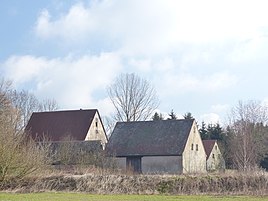
Brandermühle
|
Brandermühle
Eckental market
Coordinates: 49 ° 35 ′ 19 ″ N , 11 ° 11 ′ 21 ″ E
|
|
|---|---|
| Height : | 311 m above sea level NHN |
| Residents : | 3 (1987) |
| Postal code : | 90542 |
|
The Eckental district of Brandermühle
|
|
The Brandermühle is a Franconian wasteland in the Erlanger Albvorland .
geography
The village is one of 17 districts of the Eckental market in the northeastern part of Middle Franconia . The at an altitude of 311 m above sea level. NHN is located about two kilometers north-northwest of the Eckental administrative center, which is on the eastern edge of Eschenau .
history
The village was probably founded around the year 1300, but the first documentary mention of the Brandermühle did not take place until 1350. Since the wasteland was referred to in old documents as Eschenauer Mühle am Brand , it had obviously belonged to the village of Eschenau from the beginning.
Due to the administrative reforms carried out in the Kingdom of Bavaria at the beginning of the 19th century , the Brandermühle became part of the independent rural community of Eschenau with the second municipal edict. In the course of the municipal territorial reform carried out in Bavaria in the 1970s , the one-place community of Oberschöllenbach was incorporated into the community of Eschenau on October 1, 1971. Together with the enlarged community of Eschenau, the Brandermühle then became part of the newly formed large community of Eckental on July 1, 1972. In 1987 the Brandermühle had three residents.
traffic
The connection to the public road network takes place mainly through a non-asphalt dirt road, which branches off from the state road St 2240 about 250 meters west of the village .
Attractions
The Brandermühle is a listed building with its residential and auxiliary buildings.
literature
- Fritz Fink: Hike through the past of the Schwabach valley - the landscape between Erlangen and Graefenberg . Self-published, Eschenau 1999, ISBN 3-00-004988-6 .
- Axel Gosoge: Eschenau 1. From the foundation to 1751 . In: Agenda 21 Eckental - Heike Liedtke (Ed.): Walks through Eckental . NOVUM Verlag & Werbung, Eckental 2012.
- Federal Statistical Office (Hrsg.): Historical municipality register for the Federal Republic of Germany. Name, border and key number changes in municipalities, counties and administrative districts from May 27, 1970 to December 31, 1982 . W. Kohlhammer, Stuttgart / Mainz 1983, ISBN 3-17-003263-1 .
Web links
- Bavarian authorities guide for the Brandermühle , accessed on May 22, 2019
- The Brandermühle in the BayernAtlas , accessed on May 22, 2019
- The Brandermühle on a historical map , accessed on May 22, 2019
Individual evidence
- ↑ a b Bavarian State Office for Statistics and Data Processing (Ed.): Official local directory for Bavaria, territorial status: May 25, 1987 . Issue 450 of the articles on Bavaria's statistics. Munich November 1991, DNB 94240937X , p. 334 ( digitized version ). , accessed on May 22, 2019
- ^ Brandermühle in the local database of the Bayerische Landesbibliothek Online . Bavarian State Library, accessed on May 11, 2019.
- ↑ Geographical location of the Brandermühle in the Bavaria Atlas , accessed on May 22, 2019
- ↑ Axel Gosoge: Eschenau 1. From the foundation to 1751 . S. 2 .
- ^ Fritz Fink: Hike through the past of the Schwabach valley - the landscape between Erlangen and Graefenberg . Self-published, Eschenau 1999, ISBN 3-00-004988-6 , p. 175 .
- ^ Federal Statistical Office (ed.): Historical municipality directory for the Federal Republic of Germany. Name, border and key number changes in municipalities, counties and administrative districts from May 27, 1970 to December 31, 1982 . W. Kohlhammer, Stuttgart / Mainz 1983, ISBN 3-17-003263-1 , p. 710 .


