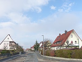
Eckenhaid
|
Eckenhaid
Eckental market
Coordinates: 49 ° 34 ′ 27 ″ N , 11 ° 13 ′ 15 ″ E
|
|
|---|---|
| Height : | 352 (324–372) m above sea level NHN |
| Residents : | 3452 (Jan. 1, 2019) |
| Postal code : | 90542 |
| Area code : | 09126 |
|
The Eckentaler district of Eckenhaid
|
|
Eckenhaid is a Franconian parish village that belongs to Eckental .
geography
The in Erlanger Albvorland preferred Pfarrdorf is one of 17 officially designated community parts of the medium Frankish market Eckental. The historic center of Eckenhaid is a little less than two kilometers east-northeast of the administrative center of Eckental. Today's center, about half a kilometer southwest of it, is at an altitude of 330 m above sea level. NHN .
history
The place was probably founded in the second half of the 11th century.
Up until the beginning of the 19th century, Eckenhaid was under the sovereignty of the imperial city of Nuremberg . The dominant village and community rule in the Franconian area for sovereignty was exercised by Count Bettschart on Immendorf in der Halden , who was a Nuremberg owner . Eckenhaid became Bavarian in 1806 after the imperial city of Nuremberg was annexed by the Kingdom of Bavaria in violation of the imperial constitution . With this violent takeover, the place became part of the New Bavarian territories that were taken over during the Napoleonic land consolidation , which was only subsequently legalized in July 1806 with the Rhenish Federal Act .
As a result of the administrative reforms carried out in the Kingdom of Bavaria at the beginning of the 19th century , Eckenhaid became an independent rural community with the second municipal edict in 1818, which still included the hamlet of Marquardsburg and the wasteland of Eckenmühle . In the course of the communal territorial reform carried out in Bavaria in the 1970s , the municipality of Eckenhaid was incorporated into the newly formed Eckental market on July 1, 1972. Eckenhaid had 3452 inhabitants in 2019.
traffic
The district road ERH 11 coming from Eschenau crosses the village and continues to the state road St 2236 . In addition, the district road ERH 9 runs through the town in a north-south direction . The public transport serving the village at a bus stop of bus number 209 of the VGN . The nearest train station is in Eschenau on the Graefenbergbahn .
Attractions
There are six listed buildings in Eckenhaid, including a former castle and three residential buildings.
literature
- Johann Kaspar Bundschuh : Eckenhaid . In: Geographical Statistical-Topographical Lexicon of Franconia . tape 1 : A-egg . Verlag der Stettinische Buchhandlung, Ulm 1799, DNB 790364298 , OCLC 833753073 , Sp. 683 ( digitized version ).
- Gertrud Diepolder : Bavarian History Atlas . Ed .: Max Spindler . Bayerischer Schulbuch Verlag, Munich 1969, ISBN 3-7627-0723-5 .
- Wilhelm Schwemmer, Gustav Voit: Lauf-Hersbruck . In: Historical Atlas of Bavaria . Commission for Bavarian State History, Munich 1967.
- Wilhelm Volkert (Hrsg.): Handbook of the Bavarian offices, communities and courts 1799–1980 . CH Beck, Munich 1983, ISBN 3-406-09669-7 , p. 458 .
Web links
- Bavarian authorities guide for Eckenhaid , accessed on October 31, 2019
- Eckenhaid in the BayernAtlas , accessed on October 31, 2019
- Eckenhaid on a historical map , accessed on October 31, 2019
- Eckenhaid in the Topographia Franconiae of the University of Würzburg , accessed on October 31, 2019.
Individual evidence
- ↑ a b Population of Eckenhaid on the Eckental website , accessed on October 31, 2019
- ↑ Eckenhaid in the local database of the Bayerische Landesbibliothek Online . Bayerische Staatsbibliothek, accessed on October 31, 2019.
- ↑ Geographical location of Eckenhaid in the Bavaria Atlas , accessed on October 31, 2019
- ^ Fritz Fink: Hike through the past of the Schwabach valley - the landscape between Erlangen and Graefenberg . Self-published, Eschenau 1999, ISBN 3-00-004988-6 , p. 158 .
- ^ Johann Kaspar Bundschuh : Eckenhaid . In: Geographical Statistical-Topographical Lexicon of Franconia . tape 1 : A-egg . Verlag der Stettinische Buchhandlung, Ulm 1799, DNB 790364298 , OCLC 833753073 , Sp. 683 ( digitized version ).
- ↑ Gertrud Diepolder : Bavarian History Atlas . Ed .: Max Spindler . Bayerischer Schulbuch Verlag, Munich 1969, ISBN 3-7627-0723-5 , p. 31 .
- ↑ Gertrud Diepolder : Bavarian History Atlas . Ed .: Max Spindler . Bayerischer Schulbuch Verlag, Munich 1969, ISBN 3-7627-0723-5 , p. 97-103 .
- ^ Wilhelm Schwemmer, Gustav Voit: Lauf-Hersbruck . In: Historical Atlas of Bavaria . Commission for Bavarian State History, Munich 1967, p. 59 .
- ^ Eckhardt Pfeiffer (Ed.): Nürnberger Land . 3. Edition. Karl Pfeiffer's Buchdruckerei und Verlag, Hersbruck 1993, ISBN 3-9800386-5-3 , p. 118 .
- ^ Sigmund Benker, Andreas Kraus (ed.): History of Franconia up to the end of the 18th century . 3. Edition. Beck, Munich 1997, ISBN 3-406-39451-5 , p. 528 .
- ↑ Gertrud Diepolder : Bavarian History Atlas . Ed .: Max Spindler . Bayerischer Schulbuch Verlag, Munich 1969, ISBN 3-7627-0723-5 , p. 35 .
- ↑ Gertrud Diepolder : Bavarian History Atlas . Ed .: Max Spindler . Bayerischer Schulbuch Verlag, Munich 1969, ISBN 3-7627-0723-5 , p. 106-107 .
- ^ Wilhelm Schwemmer, Gustav Voit: Lauf-Hersbruck . In: Historical Atlas of Bavaria . Commission for Bavarian State History, Munich 1967, p. 141 .
- ^ Wilhelm Volkert (ed.): Handbook of Bavarian offices, communities and courts 1799–1980 . CH Beck, Munich 1983, ISBN 3-406-09669-7 , p. 458 .


