Branisko Pass
| Branisko Pass | |||
|---|---|---|---|
|
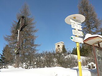
Cross and monument on the top of the pass |
|||
| Compass direction | west | east | |
| Pass height | 751 m nm | ||
| Kraj | Prešovský | ||
| Watershed | Margecianka → Hornád → Sajó → Tisza → Danube | Svinka → Hornád → Sajó → Tisza → Danube | |
| Valley locations | Korytne | Siroké | |
| expansion | Road I / 18 , Autobahn D1 (tunnel) | ||
| Mountains | Branisko | ||
| Map (Prešovský) | |||
|
|
|||
| Coordinates | 49 ° 1 '3 " N , 20 ° 51' 26" E | ||
The Braniskopass ( Slovak priesmyk Branisko , German rarely Purzelgrund , Hungarian Branyiszkó szoros , popularly also Chvalabohu - German literally "Thank God") is a mountain pass in eastern Slovakia . It crosses the Branisko Mountains and lies on the way from Poprad to Prešov , between the Spiš and Šariš regions . At the top of the pass there is a good view of Spiš ( Spiš Castle , Spišské Podhradie ), in good weather the High Tatras can also be seen.
On February 5, 1849, in the course of the revolutions of 1848/49, a battle between the imperial troops and the Hungarian Honvéden took place on the pass , from which the Honvéden emerged victorious.
The road over the pass was an obstacle to traffic, especially because of the serpentines on the west ramp. In 2003 it was replaced by the Branisko tunnel (currently only single-tube) on the D1 motorway .

