Breckenridge, Minnesota
| Breckenridge | |
|---|---|
 Center of Breckenridge |
|
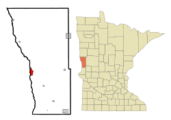
| Breckenridge in Wilkin County | |
| Basic data | |
| State : | United States |
| State : | Minnesota |
| County : | Wilkin County |
| Coordinates : | 46 ° 16 ′ N , 96 ° 35 ′ W |
| Time zone : | Central ( UTC − 6 / −5 ) |
| Residents : | 3,386 (as of 2010) |
| Population density : | 555.1 inhabitants per km 2 |
| Area : | 6.1 km 2 (approx. 2 mi 2 ) of which 6.1 km 2 (approx. 2 mi 2 ) is land |
| Height : | 293 m |
| Postal code : | 56520 |
| Area code : | +1 218 |
| FIPS : | 27-07462 |
| GNIS ID : | 0640448 |
| Website : | www.breckenridgemn.net |
| Mayor : | Clifford W. Barth |
 The 1928 in the Beaux-Arts style built Wilkin County Courthouse in Breckenridge, since 1880 NRHP listed |
|
Breckenridge is a small town (with the status " City ") and the administrative seat of Wilkin County in the US -amerikanischen State Minnesota . In 2010 Breckenridge had 3,386 residents.
geography
Breckenridge is located at the confluence of the Bois de Sioux River and Otter Tail River to the Red River of the North . The Bois de Sioux River and the Red River form the border to the neighboring city of Wahpeton in North Dakota . The geographical coordinates of Breckenridge are 46 ° 15'59 "north latitude and 96 ° 35'04" west longitude. The urban area extends over an area of 6.1 km².
Neighboring towns to Breckenridge are Wahpeton (on the opposite bank of the river), Kent (13.8 miles north-northwest) and Doran (8 miles southeast).
The closest major cities are Fargo in North Dakota (74 km north-northwest), Duluth on Lake Superior (380 km east-northeast), Minneapolis (324 km southeast), Minnesota's capital Saint Paul (345 km in the same direction), and Sioux Falls in South Dakota (341 km south).
traffic
The most important thoroughfare for road traffic is the four-lane US Highway 75 , which meets Minnesota State Routes 9 and 210 in the urban area of Breckenridge . Breckenridge is connected to Wahpeton by two bridges. All other roads are subordinate country roads, some unpaved roads and inner-city connecting roads.
A BNSF Railway runs through Breckenridge .
The Harry Stern Airport in Wahpeton is 3.1 km southwest of a small airfield. The nearest major airports are Hector International Airport in Fargo (84.5 km north-northwest) and Minneapolis-Saint Paul International Airport (348 km southeast).
Demographic data
| Population development | |||
|---|---|---|---|
| Census | Residents | ± in% | |
| 1890 | 655 | - | |
| 1900 | 1282 | 95.7% | |
| 1910 | 1840 | 43.5% | |
| 1920 | 2401 | 30.5% | |
| 1930 | 2261 | -5.8% | |
| 1940 | 2745 | 21.4% | |
| 1950 | 3623 | 32% | |
| 1960 | 4335 | 19.7% | |
| 1970 | 4200 | -3.1% | |
| 1980 | 3909 | -6.9% | |
| 1990 | 3708 | -5.1% | |
| 2000 | 3559 | -4% | |
| 2010 | 3386 | -4.9% | |
| 2012 estimate | 3387 | 0% | |
| 1890-2000 2010 2012 | |||
According to the 2010 census , Breckenridge had 3,386 people in 1,445 households. The population density was 555.1 people per square kilometer. Statistically, there were 24 people living in the 1445 households.
The racial the population was composed of 96.3 percent white, 0.2 percent African American, 1.4 percent Native American, 0.4 percent Asian and 0.3 percent from other ethnic groups; 1.4 percent were descended from two or more races. Regardless of ethnicity, 2.5 percent of the population was Hispanic or Latino of any race.
23.3 percent of the population were under 18 years old, 55.5 percent were between 18 and 64 and 21.2 percent were 65 years or older. 51.0 percent of the population was female.
The average annual income for a household was 46,223 USD . The per capita income was $ 23,184. 8.4 percent of the population lived below the poverty line.
sons and daughters of the town
- Cheryl Tiegs (* 1947), model
- Gerry Sikorski (* 1948), politician
- Heidi Heitkamp (* 1955), politician
- Chuck Klosterman (* 1972), author and journalist
Individual evidence
- ↑ Extract from the National Register of Historic Places - No. 80002182.Retrieved July 14, 2013
- ↑ a b c American Fact Finder. Retrieved July 14, 2013
- ↑ Distance information according to Google Maps. Accessed on July 14, 2013
- ↑ AirNav.com - Harry Stern Airport Retrieved on July 14, 2013
- ↑ US Decennial Census. Retrieved July 14, 2013
- ↑ US Census Bureau - Estimate for 2012 ( Memento of the original from July 10, 2013 in the Internet Archive ) Info: The archive link was inserted automatically and has not yet been checked. Please check the original and archive link according to the instructions and then remove this notice. Retrieved July 14, 2013
