
Bristow (Schorssow)
|
Bristow
municipality Schorssow
Coordinates: 53 ° 42 ′ 45 ″ N , 12 ° 37 ′ 24 ″ E
|
|
|---|---|
| Height : | 7 m above sea level NHN |
| Area : | 16.04 km² |
| Residents : | 243 (Jan. 1, 2012) |
| Population density : | 15 inhabitants / km² |
| Incorporation : | June 13, 2004 |
| Postal code : | 17166 |
| Area code : | 039933 |
 Bristow village church
|
|
Bristow is a district of the community Schorssow in the southeast of the Rostock district in Mecklenburg-Western Pomerania . The place belongs to the Office of Mecklenburg Switzerland and was an independent municipality until June 13, 2004.
location
Bristow is located in Mecklenburg Switzerland on Lake Malchin , around eight kilometers as the crow flies south of Teterow and ten kilometers west-southwest of Malchin . Surrounding villages are Glasow in the north, Wendischhagen in the northeast, Basedow in the east, Seedorf in the south, Bülow in the southwest and Tessenow and Grube in the west.
Bristow is on Kreisstraße 44, the federal highway 108 as the next national road is about seven kilometers from the village. The Gruber Forst nature reserve is located in the area of the former community of Bristow .
history
The Bristow estate was first mentioned in a document in 1297. Since 1352 the manor was owned by the von Hahn family . The village church was built in the 1590s and completed in 1601. After the Thirty Years' War it was initially a branch church of Hohen Demzin and in 1790 became a branch church of the village church of Bülow . In the Thirty Years War several buildings in Bristow were destroyed, after the end of the war only one farming family lived in the village. In 1845 Bristow came into the possession of the Lords of Bassewitz - Levetzow . They had a mansion built in the Tudor style in 1866. In addition, several farm buildings were built and in 1891 a pigeon house . The Bristow manor burned down in 1919.
On April 1, 1921, the communities Glasow, Grube and Tessenow were incorporated into Bristow, but were spun off again shortly afterwards. Until 1925, Bristow belonged to the Stavenhagen Office , which was finally transformed into the Malchin Office . In 1933, Bristow came with the merger of Mecklenburg-Schwerin and Mecklenburg-Strelitz to the newly established district of Malchin . The lords of Bassewitz-Levetzow were expropriated in the course of the land reform in the Soviet occupation zone in 1945 and the land was distributed among new farmers. After the expropriation, resettlers from the eastern German territories lived in the former manor buildings. On July 1, 1950, Glasow, Grube and Tessenow were again incorporated into Bristow.
During the GDR era, an agricultural production cooperative was established in Bristow , which was converted into an agricultural cooperative in 1990. In the GDR, the municipality of Bristow belonged to the Teterow district from July 25, 1952 and, after reunification, to the Teterow district . This merged on June 12, 1994 with the districts of Bützow and Güstrow to form the new district of Güstrow . On June 13, 2004, the community of Bristow merged with the neighboring community of Bülow (near Malchin) to form the new community of Schorssow. Bristow has been part of the Rostock district since September 4th, 2011 .
Attractions
Architectural monuments
In the list of architectural monuments in Schorssow , three architectural monuments are listed for Bristow :
- The Bristow village church was built in the 1590s and is one of the oldest Protestant village churches in Mecklenburg. The church was donated by Werner Hahn zu Basedow and furnished in the Renaissance style. Most of the equipment is still original. In the 1990s, the church was renovated with the participation of the German Foundation for Monument Protection . The Bassewitz family mausoleum has been located next to the village church since 1874 .
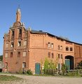
- The manor in Bristow was built in 1868 by Count Carl August von Bassewitz-Levetzow, the manor includes a stables , a granary and a field stone barn as well as the pigeon house built in 1891 , the manor itself burned down in 1919 and was not rebuilt.
- War memorial 1914/1918

Bassewitz's mausoleum and church in Bristow

Marstall in Bristow
Storage in Bristow

Pigeon House in Bristow


Personalities
- Werner Graf von Bassewitz-Levetzow (1894–1964), sea captain in World War II and commander of the 2nd Marine Infantry Division; born in Bristow
Web links
Individual evidence
- ↑ Müller's Large German Local Book 2012: Complete local dictionary. 33. revised and exp. Ed., Walter de Gruyter, Berlin and Boston 2012, ISBN 978-3-11-027420-2 , online at Google Books , p. 197
- ^ Community of Schorssow. Mecklenburg Switzerland Office, accessed on December 1, 2019.
- ↑ Jana Jürß: 111 places in the Mecklenburg Lake District that you have to see. Emons Verlag, 2015, p. 41 .