Burns (Oregon)
| Burns | |
|---|---|
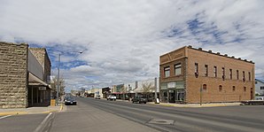
 North Broadway Avenue (2008) |
|
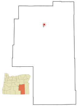
| Located in Harney County and Oregon | |
| Basic data | |
| Foundation : | 1889 (inc.) |
| State : | United States |
| State : | Oregon |
| County : | Harney County |
| Coordinates : | 43 ° 35 ′ N , 119 ° 4 ′ W |
| Time zone : | Pacific ( UTC − 8 / −7 ) |
| Residents : | 2,729 (as of 2010) |
| Population density : | 297 inhabitants per km 2 |
| Area : | 9.19 km 2 (about 4 mi 2 ) of which 9.19 km 2 (about 4 mi 2 ) is land |
| Height : | 1264 m |
| Postal code : | 97720 |
| Area code : | +1 541 |
| FIPS : | 41-09800 |
| GNIS ID : | 1118337 |
| Website : | www.ci.burns.or.us |
Burns is a settlement type a city in the US state of Oregon and the administrative seat of Harney County . Despite the only 2729 inhabitants in the US Census 2010, Burns, together with the directly adjacent, smaller sister city of Hines, is the supply center for the almost uninhabited southeastern quadrant of Oregon and has an essential central function with a high school , hospital and shopping facilities .
location
Burns is located at over 1200 m above sea level in the Oregon High Desert in the far north of the Great Basin below the Blue Mountains . The surrounding Harney Basin is a drainless water catchment area, the lowest point of which is Malheur Lake around 45 km south of the city. The basin extends further south to Steens Mountain .
In Burns, the crosses US Highway 20 in the east-west direction with the coming of the North US Highway 395 , the Burns Municipal Airport ( IATA : BNO) is an airport for general aviation with no regular service. On public transport, there has been a bus connection to the Oregon POINT system since 2011 . The bus runs once a day in each direction on US Highway 20 to Ontario on the Idaho border in the east and to Bend in the west.
From 1924 to 1984 Burns was connected to Ontario , Oregon and on to Idaho by a railway branch line called the Oregon Eastern Branch and operated by Union Pacific Railroad . The line was only used for freight traffic and almost exclusively transported logs and wood products that came from the forests north of Burns and the sawmills in Seneca , Oregon via the Oregon and Northwestern Railroad or from Hines to Burns. The railway line was hardly used at the beginning of the 1980s and was not reopened in 1984 after the rails were flooded.
history
Originally the region was home to the Wada Ticutta - Paiute Indians. The desert highlands were not suitable for permanent settlements, which is why the Paiute mainly used the region for hunting.
From the 1860s, white homesteaders began to settle in the area. They set up large-scale cattle ranches and used irrigated fields for growing cattle feed, mainly alfalfa . Conflicts between the Paiute and the settlers were suppressed by violence when, in 1867, Camp Harney , a military post, was built just under 20 km northeast of the present city. In 1872 the Paiute were granted a large Indian reservation, but their borders were systematically violated. The soldiers at the camp did not protect the Paiute or their rights. A widespread uprising by the Paiute in this and other reservations was forcibly suppressed in 1878 as the Bannock War , the surviving Indians captured and settled over 500 km away in the Yakama Indian Reservation in today's Washington state . The military post was dissolved in 1880, the reserve in 1889, the land reverted to the federal government and some of it was given to settlers.
The name of the place comes from the author Robert Burns . When the owner of the first shop and administrative agent George McGowan also took over the region's first post office in 1884, he was able to determine the name of the post office. He chose the Scottish poet because he valued him as a popular poet.
When in 1889 the southern part of Grant County was separated as Harney County, Burns became the seat of the administration of the new county. In 1891 Burns became an independent City through incorporation .
In the 1930s, Paiute bought 760 acres north of Burns through New Deal programs and built simple homes with the Bureau of Indian Affairs . Between 1936 and 1968 they consolidated their tribal structures, elected representatives and in 1972 they were recognized by the federal government as the Burns Paiute Tribe . At the same time, the Burns Paiute Reservation was established. Individual Paiute families also own farms with a total size of over 40 km² east of the city, which are held in trust by the Bureau of Indian Affairs as allotment land under the Dawes Act . Both the direct ownership and the allottment land are largely leased to ranchers.
Agriculture is still the economic base of the region, forestry was the basis of the neighboring town of Hines . Most of the cultivated land around Burns is owned by the US federal government and administered by the Bureau of Land Management . The land is leased to private ranchers. Eight herds of wild horses with around 1,000 animals live on reserved areas in the south and west of Burns.
Since 1960 Burns has had a small museum dedicated to the history of the area, run by the Harney Historical Society. Burns attracts national visitors annually in April and September. On the occasion of the spring bird migration at the Malheur National Wildlife Refuge , the city hosts a festival with music and art. County Fairs have been held in Burns in the autumn since 1888 , with a mixture of a fair and a trade show. One of the largest rodeos in Oregon has been held every year since the 1920s .

The National Park Service lists five structures and sites for Burns on the National Register of Historic Places as of January 11, 2019, including the Pete French Round Barn .
National Register of Historic Places
| Reference number | Surname | address | Registration on | |
| 80003314 | Allison Ranger Station | NO from Burns | September 12, 1980 | |
| 82001502 | Double-O Ranch Historic District | Double-O County Rd. | October 25, 1982 | |
| 71000679 | Pete French Round Barn | N of Diamond Station | September 10, 1971 | |
| 79002060 | P ranch | S by Burns | January 29, 1979 | |
| 79002061 | Sod House Ranch | S by Burns | January 29, 1979 |
Web links
supporting documents
- ^ Oregon Point: Eastern Point
- ^ Abandoned Rails: The Oregon Eastern Branch
- ↑ Burns Paiute Tribe: The Bannock Indian War ( Memento of the original from March 1, 2016 in the Internet Archive ) Info: The archive link was inserted automatically and has not yet been checked. Please check the original and archive link according to the instructions and then remove this notice. , 2008
- ↑ Harney County Chamber of Commerce: Community ( Memento of the original from November 6, 2014 in the Internet Archive ) Info: The archive link was automatically inserted and has not yet been checked. Please check the original and archive link according to the instructions and then remove this notice.
- ↑ Burns Paiute Tribe: Wadatika northern Paiute history ( Memento of the original from January 17, 2016 in the Internet Archive ) Info: The archive link was inserted automatically and has not yet been checked. Please check the original and archive link according to the instructions and then remove this notice. . In: Burns Times Herald: Destination Harney County , 2012
- ↑ Bureau of Land Management: Map showing ownership
- ^ Bureau of Land Management: Wild Horse Program
- ↑ Birders Flock to Harney County for April Festival ( Memento of the original from January 17, 2016 in the Internet Archive ) Info: The archive link was inserted automatically and has not yet been checked. Please check the original and archive link according to the instructions and then remove this notice. . In: Burns Times Herald: Destination Harney County , 2012
- ^ Harney County Chamber of Commerce: Harney County Fair, Rodeo & Race Meet
- ↑ Search mask database in the National Register Information System. National Park Service , accessed January 11, 2019.
