
Carsulae

Carsulae was a Roman city and a regionally important trading center. The archaeological site is in the province of Terni in the Umbria region near the town of San Gemini .
location

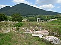
The history of the place and the archaeological findings of the excavations are shaped by the geophysical conditions of this area. The city extends 500 m above sea level on a plain at the foot of the Martani Mountains. To the east of the city leans on the slope of Mount Torre Maggiore (1121 m) and is located on one of the advancing there travertine - Plateau , providing free on three sides view in the surrounding area. The light foundation walls of the center of the ancient city of Carsulae stand out clearly from the surroundings. The Roman writer Tacitus also mentioned the city's particularly favorable location . In one of his reports on the fighting in the four-emperor year 69 AD, he noted that the commanders of Vespasian in Carsulae allowed themselves a few days of rest. They would have liked the place because it offered a wide view and the food supply was assured. Pliny the Elder probably also referred to this fertile plain when he discussed the cultivation of viticulture in Umbria in his Naturalis historia .
The closest cities in ancient times were Interamna ( Terni ), Spoletium ( Spoleto ), and Narnia ( Narni ).
history

The settlement of the place took place relatively late compared to other Italian centers. Remains of earlier settlements were found in the vicinity, including polygonal walls from the 5th and 4th centuries BC. At Cesi , but the archaeological relics of the city of Carsulae itself date from a much later period.
A first settlement could be after the construction of the Via Flaminia 220 BC. BC, which after its completion connected Rome with Ariminum ( Rimini ). However, no archaeological relics from the 3rd or 2nd century BC have been found so far. In the vicinity of the forum there are remains of buildings from the late Republican era. Most of the public buildings whose traces have been preserved date from the reign of Emperor Augustus . They were probably made shortly after the restoration of the Via Flaminia in 27 BC. Built in BC. The location and execution of the buildings in the center indicate a uniform design.

The flourishing of the city is mainly due to the connection to the Via Flaminia, which had developed into an important traffic artery. Apparently Carsulae achieved some prosperity as a supply station and transshipment point. Strabo mentions Carsulae in his list of the most important places on the Via Flaminia in his Geographika. Other buildings date from the early imperial era, i.e. from the Julio-Claudian and the Flavian epochs. From the inscriptions it appears that the building activities continued into the 3rd century AD.
Carsulae has apparently always been a Municipium and therefore had communal self-government under the rule of Rome. End of the 1st century BC The place was apparently administered by a college of two men (duovires). Later, a four-man quattuorvires were introduced to administer the city. The city of Carsulae does not appear to have any city walls at any time, as their location, function and time of construction made such fortifications superfluous.
The city's decline probably began as early as the late imperial period of the 3rd century AD, as the relocation of the Via Flaminia to the east probably caused a lasting economic crisis. No inscriptions were made after the reign of Emperor Diocletian . In the middle of the 4th century AD, an earthquake is believed to have damaged large parts of the city. It can also be assumed that the unprotected city was plundered repeatedly during the migration . In any case, the city was abandoned in late antiquity and the residents probably moved to San Gemini.

Over the next few centuries, the abandoned city was covered by debris from the surrounding hills and served as a quarry for San Gemini , Acquasparta , Cesi and numerous smaller towns. Some nuns of probably settled in the 11th century Benedictine - the Order on the abandoned site of Carsulae down and founded a monastery . At that time a small church was built, which is dedicated to Saints Cosmas and Damian and is still preserved. In 1220 there were apparently a hundred nuns here when Pope Honorius III. moved them to another place. In 1230 Pope Gregory IX handed over the the monastery complex to the order of the Cistercians .
In the 16th century, Federico Cesi carried out the first excavations of the complex. Its main objective, apparently, was to secure Roman artifacts which were subsequently exhibited at the Palazzo Cesi in Acquasparta. In 1783 Pope Pius V organized an extensive excavation of the most important buildings and brought the finds to the new Museo Pio Clementino in the Vatican . The Archbishop of Spoleto carried out further excavations in 1851, but many of the finds were sold to cover the cost of the project. The place got its present appearance through systematic excavations under Umberto Ciotti between 1951 and 1972. These excavations focused on the area of the forum, the amphitheater and the theater. The paved Via Flaminia was discovered at this time.
Excavation site

.JPG)
Since Carsulae was abandoned in late antiquity, the excavations had the advantage that only a few of the ancient remains were covered by later overbuilding. However, the buildings were used as a quarry in the Middle Ages , so that the buildings have only been preserved up to a low height. Even before the excavations began in 1951, the buildings just below the sward were visible as relief-like elevations. It can be assumed that not only the important public buildings of the city that are uncovered today have been preserved, but that the entire rest of the ancient city is still hidden under the ground.
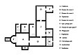
First of all, the axial arrangement of the theater and amphitheater , which is due to the exploitation of the soil formation, is striking . The theater (1) and the semicircular auditorium (cavea) nestle against the slope of Monte Torre Maggiore. A towering stage wall (scaenae frons) used to close off the theater. Large blocks have been preserved from the upper entablature. The semicircular auditorium has a diameter of 62 m. Like most of the city's buildings, theaters and amphitheaters are likely to have been built in the 1st century AD, as the wall technology used ( Opus reticulatum ) suggests.

The amphitheater (2) lies slightly rotated to the axis of the theater in a depression that was created as a result of a sinkhole collapse . The karstification of the soil creates underground cavities above which the soil eventually collapses. This was useful for the construction of the amphitheater and allowed the lower rows of seats to be cut into the walls of the depression. The amphitheater is secured by retaining walls in the north and south. The elliptical amphitheater is with major axes 87 m and 62 m unusually large for a place as small as Carsulae. Apparently, the easily accessible city had a certain importance for the surrounding towns, so that the theater and amphitheater had to offer space for visitors from a larger catchment area.

The remains of a cistern (3) were uncovered south of the amphitheater . A water canal (4) between the amphitheater and the theater was used to flood the arena for the popular performances of sea battles ( naumachia ). To the north of the theater are the remains of a building (5), the entrance and interior of which were equipped with columns. It is assumed that the club building (Schola) of the local youth association (Collegium iuvenum) was located here. Such associations existed in numerous cities in the Roman Empire. The existence of this institution in Carsulae is evidenced by inscriptions that are now in San Gemini.
At one point near the amphitheater (5) a sinkhole caused some damage. Part of the ancient road that leads from Via Flaminia to the amphitheater has sunk. The buildings in the immediate vicinity were also affected by the collapse. Today you can still clearly see the place where the road was repaired by construction workers in antiquity. The slipped white paving was left in place and the road was repaired with reddish limestone.
All other important buildings in the city center are aligned with Via Flaminia (7) as the north-south axis ( Cardo ). The trapezoidal forum (8) lies west of Via Flaminia and was originally paved with slabs of pink marble , some of which can still be found. There was a monumental four-sided arch ( quadrifrons ) at the two eastern entrances to the forum (9 ). To compensate for the floor level, 12 steps lead from Via Flaminia to the southern arched passage, while the northern arched passage allows almost level access to the forum. An arch of the southern entrance was rebuilt.

At the south-eastern end of the forum are two temples (10), which are very similar in plan and structure. They each consisted of an inner main room ( cella ) with a vestibule on each podium . The front of the temples was probably formed by four columns each. Below and behind the podium were the remains of a possibly Republican colonnade ( portico ). Since the two temples are very similar, it can be assumed that the two temples were dedicated to the divine brothers Castor and Pollux . Even if the execution in two temples of the same type appears unusual, it would be appropriate for the pair of twins, since the Dioscuri were worshiped as the Roman patron gods. Behind the eastern of the two podiums are rooms (10), which probably served as shops (tabernae).
On the other side of the forum, opposite the twin temples, there are four rooms (11) next to each other, all of which are of different sizes and each marked by an apse on their front side . In the largest room, the apse was later closed by a plastered brick wall. The reason and purpose for this are unknown. All of these rooms are lined with marble. The location and the equipment of the rooms suggest that these are public buildings. A larger than life headless seated statue and a portrait head of the emperor Claudius were found in the immediate vicinity . It is assumed that both finds belong together. Together with other statue fragments, these finds seem to indicate that part of the building served the imperial cult . Recent research suggests that the largest room was the meeting place of the Senate ( Curia ).
On the west side of the forum, the remains of a small temple (12) have been excavated, fragments of the entablature and ornamental decorations of the furnishings have been preserved. It is very likely that this is the Capitolium of Carsulae, the sanctuary located in almost every city, which was dedicated to the Capitoline Triassic consisting of the deities Jupiter , Juno and Minerva .

On the eastern side of Via Flaminia is a basilica (13) which in ancient times served as a courtroom, stock exchange and trading center. The building has only been preserved up to floor level in the west and east, otherwise you can only see the foundations. Columns or pilasters , the plinths of which have been partially preserved, divided the space into three naves with an apse to the east. To the south of the basilica are the foundation walls of a building (14) that may have served as a hostel ( hospitium ) for travelers passing through.

At the southern end of the city center is the small church (15), which was built in the 11th century on ancient remains and is dedicated to Saints Cosmas and Damian . The vestibule ( portico ) was added at a later date and was created using numerous remains of ancient columns ( spolia ). The relief in the arched field ( tympanum ) above the portal shows two figures of saints who receive healing water from the cross. A wall in the church may be the wall of an ancient building. It consisted of arcades , which were later given a brick filling. Due to the location of the building near the forum, it can be assumed that the previous building was the market building ( Macellum ). The church originally consisted of a nave and an apse with a narrow window ( monoforium ). The arcade on the left seems to have been a later addition. There was probably a similar arcade to the right. There are remains of frescoes on the back wall and in the apse. The church was restored in 1691.

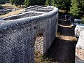
Although the city had no walls, the urban area was delimited by two gates that spanned the Via Flaminia. The middle of three arches is still preserved from the north gate (16). As can be seen from the foundations, the two side passages were narrower and lower. The passage is also known as the Arch of Trajan (Arco di Traiano) or Arch of Saint Damian (Arco di San Damiano). As was customary in Roman antiquity, the graves lie in front of the gate to delimit the city.
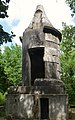
A round grave (17) with a drum 17 m in diameter, which sits on a square pedestal , is particularly well preserved . The structure and the battlements could be partially reconstructed. Since the filling of the drum and the attached earth tumulus are missing, the structure of the circular grave can be seen today. Six walls extend from a central core and lead radially to the grave wall. They served to keep the earth pouring out. In the outer wall of the drum there was an inscription tablet (tabula) which gives the name of the family ( Gens ) Furia, who probably belonged to the grave. The inscription, which dates from the second half of the 1st century AD, is dedicated to the father and son, both of whom were called Caius Furius Tiro and who each served as members of the four-man college. The dedication was made by Lucius Nonius Asprenas and two women from the Gens Furia.
Among the other graves along the road, there is another tomb of note. The so-called tower grave (18) is built on the same principle as the round grave. Here, too, a round attachment rests on a square base, but the proportions are much more elongated. This tomb is likely to have originated in the late republic or at the beginning of the imperial era, as stylistic studies of the metope-triglyphic frieze have shown. Weapons, animals and ornamental figures are depicted in the metopes.
In the south of the city there is another cistern (19) which, together with the other cisterns, ensured the city's water supply for several centuries. At the southern end of the city were the thermal baths (20), which were fed by natural springs. The first excavations took place here in 1783, during which a mosaic floor with sea scenes was discovered. During the archaeological excavations from 1951 to 1972, a rectangular room with an apse and a mosaic pavement was uncovered. Exploration of the thermal baths was resumed in 2004 by Jane Whitehead and Max Cardillo. Further rooms were uncovered and the first reconstructions of the building complex were made. As part of the project, a master plan was also developed for improved development of the entire archaeological site.
gallery

Orchestra of the theater

Scenae of the theater
Cavea of the theater

Amphitheater arena

Via Flaminia near the forum

Northern access to the forum

North side of the forum with public buildings

Temple of Castor and Pollux

Twin temples and southern quadrifrons
View from the Capitolium to the Forum

Church of Cosmas and Damian

Interior of the church

North gate with round grave

Round grave

Reconstruction of the circular grave

Foundation of the circular grave
Tower tomb
Reconstruction of the thermal baths

_1.JPG)


literature
- Anita Rieche : Ancient Italy from the air. 2nd edition, Lübbe Verlag, Bergisch Gladbach 1987, ISBN 378570223X , pp. 104-111.
- Umberto Ciotti: Carsulae. In: Alberto Violati (ed.): San Gemine e Carsulae. Carlo Emili Bestetti Editore, Milan / Rome 1976, pp. 10–80. ( online )
Web links
- Carsulae - Parco Archeologico
- Key to Umbria: Carsulae
- San Gemini Preservation Studies
- Imperium Romanum: Carsulae
- I Luoghi del Silenzio: Città romana di Carsulae - Terni (TR)
- Polo museale dell'Umbria: Area archeologica di Carsulae
Individual evidence
- ^ Tacitus, Historiae 3, 60.
- ↑ Pliny the Elder, Naturalis historia 17, 35.
- ^ Strabo, Geographika 5, 2, 10.
- ↑ CIL 11, 4579
- ↑ CIL 11,4580
- ↑ CIL 11,4572
- ^ Carsulae: Archaeological Excavation of the Public Baths. In: sangeministudies.info. Retrieved May 30, 2019 .
Coordinates: 42 ° 38 ' N , 12 ° 33' E