
Khreshchatyk (Kiev)
| Khreshchatyk Хрещатик
|
|
|---|---|
|
|
|
 |
|
| Basic data | |
| place | Kiev |
| Rajon | Shevchenko , Pechersk |
| Connecting roads | Bohdan Khmelnitsky Street , Lutheran Street |
| Places | Majdan Nezalezhnosti |
| Buildings | Khreshchatyk 42 , Central Department Store "TO", Khreshchatyk 25 , the City Council building , building of the Ministry of Forestry , Russian Foreign Trade Bank , Kiev Passage , Khreshchatyk 13 , General Post Office , House of Unions , Volga-Kama Bank , St. Petersburg account and credit bank |
| Kiev Metro |
|
| use | |
| User groups | Pedestrian traffic , bicycle traffic , car traffic , public transport |
| Technical specifications | |
| Street length | 1200 meters |
The Khreshchatyk (Ukrainian Хрещатик ; Russian Крещатик / Khreshchatyk ) is the central street of the Ukrainian capital Kiev . On the one hand, the Chreschtschatyk has the function of a six-lane main thoroughfare , on the other hand, due to its wide sidewalks, the 80 to 100 meter wide boulevard is also a promenade . On weekends and on some public holidays, the Khreschtschatyk is closed to car traffic during the day and thus becomes a pedestrian zone at times .
The name of the street is derived from the Slavic word krest or chrest ( cross ).
Course of the road
The Khreschtschatyk extends over a length of 1.2 kilometers from the European Square to the Bessarabska Square , i.e. from northeast to southwest. He crosses the Majdan Nesaleschnosti (Independence Square). The “ Khreschtschatyk ” metro stations , which can be accessed at Khreschtschatyk house number 19a, and the “ Majdan Nesaleschnosti ” station connected to it are located directly below the boulevard. The shopping centers “Metrograd” and “Globus” are also located below the street.
Right on Khreshchatyk are important and representative structures, such as the building of the City Council and City Parliament (Ukrainian Київрада ), the General Post Office , the Ministry of Agriculture of Ukraine and in the style of Constructivism Built, Central Department Store "TO" ( ЦУМ ).
While on the street side with the even house numbers, long and high blocks of houses dominate, which mostly serve administrative purposes, on the side with the odd house numbers, residential buildings in the confectioner's style , such as the 85 m high house Khreschtschatyk 25 , characterize the street scene . There are shops and cafes on their ground floors.

history
The Khreshchatyk was a poorly developed connection between the districts of Podil , Pechersk and the upper town until the 19th century . In the second half of the 19th century it developed into the central promenade of Kiev and into a commercial and business center. In 1892 the first electric tram line in Russia ran here .
Fighting activities during the October Revolution , the occupation of the city by the Germans (1918) and the Russian Civil War caused considerable damage to many buildings. After the victory of the Bolsheviks, conversions in line with socialist architecture were carried out or planned. The tram was replaced by trolleybuses .
During the German-Soviet War , German troops took Kiev in September 1941. The retreating Red Army mined many buildings in the city center and detonated them remotely after taking the city. The explosions also caused great damage to the Khreshchatyk. During the time of the German occupation of Khreshchatyk after the German Field Marshal was Hermann von Eichhorn , who was assassinated fallen victim here in 1918, in Eichhornstrasse been renamed. When Soviet troops retook Kiev in November 1943, large parts of the city were in ruins.
As early as 1945, under the direction of the architects Alexander Vlasov and Boris Prijmak, the reconstruction of the Khreshchatyk began, creating a largely harmonious ensemble in the style of the Soviet architecture of Stalinism ( socialist classicism ).

Khreshchatyk at the beginning of the 20th century
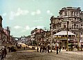
Khreshchatyk 1899

Khreshchatyk on the weekend
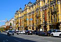
Chreschtschatyk, in the foreground on the left the central department store "ZUM"


literature
- Günther Schäfer: Discover Kiev: tours through the metropolis on the Dnepr (= Trescher series of trips). Trescher, Berlin, 2nd edition 2007, ISBN 978-3-89794-111-3 .
Web links
- Claus Seyfried: The Khreschatik. In: csey.de. April 8, 2009 (private website with some photos).
- Ukraine Photos: Kiev (Kyiv): Kreschatik. In: Ukrainian.SU. Archived from the original on March 3, 2016 .
Individual evidence
- ↑ Map of Kiev, special edition A, scale 1: 25,000. (Jpg, 31.6 MB) War Maps and Surveying Office Kiev, January 1943, accessed on November 22, 2019 (grid squares M8 – M9).
Coordinates: 50 ° 26 ′ 58.5 ″ N , 30 ° 31 ′ 24.2 ″ E