
Dannigkow
|
Dannigkow
City of Gommern
|
|
|---|---|
 |
|
| Height : | 55 m above sea level NHN |
| Area : | 12.06 km² |
| Residents : | 613 (December 31, 2017) |
| Population density : | 51 inhabitants / km² |
| Incorporation : | January 1, 2005 |
| Postal code : | 39245 |
| Area code : | 039200 |

| |
Location of Dannigkow in Saxony-Anhalt |

Dannigkow is a district of the city of Gommern in the Jerichower Land district in Saxony-Anhalt .
geography
It lies on the border between the Magdeburg Elbe and West Fleming at 54 meters above sea level. The Elbe tributary Ehle flows through the town from north to west . The surrounding area is dominated by agriculture with soils of medium yield, further to the south-west begins with the Gommersche Heide a larger forest area, in which the local recreation center Lake Balaton is located. On the edge of the village of Dannigkow, the federal highway 184 runs , which connects the village with Gommern, and on which the state capital Magdeburg can be reached after 21 kilometers and the next town Zerbst after 20 kilometers. To the east of Dannigkow is the district of Kressow .
In terms of natural space , the place belongs to the Zerbster Land , an arable, open cultural landscape and 536 km² main unit of the superordinate main unit group of the Fläming in the north German lowlands . The Zerbster Land forms the southwestern roof of the Fläming to the Elbe and belongs to the catchment area of this river.
structure
The district of Kressow belonged to the former community of Dannigkow.
history
The place name, which appears in written records for the first time in 1142, is of Slavic origin. German settlement began in the 12th century at the latest, as the village church dates from this time. In addition to agriculture, the quarries south of the village were of great importance. Both the monastery in Plötzky , the parish church in Leitzkau and the castle in Gommern were built with quarry stones from Dannigkow. Until 1808 the place belonged to the Electoral Saxon Office of Gommern, which formed an enclave in Magdeburg . Then Dannigkow was part of the French bridgehead east of the Elbe for six years after Saxony had ceded the office of Gommern to the Kingdom of Westphalia . During the Wars of Liberation against Napoleon , the village was one of the scenes of the Battle of the Ehl on April 5, 1813 . After a bitter struggle for every house, the allied Prussian-Russian troops were able to drive out the French entrenched in the village and thus ensure an initial success in the struggle for liberation from Napoleonic rule. A memorial stone in front of the Dannigkower town hall reminds of the battle.
At the end of the 19th century, work in the Dannigkow quarries had reached its peak. There were eleven quarry companies operating, some of which worked with steam engines. At that time 610 (1910) people lived in the village. On October 15, 1963, the last operation ceased and the quarries were flooded. The largest of the newly created lakes was named Lake Balaton and became the center of a local recreation area with a campsite. In 1964 Dannigkow had 845 inhabitants.
The favorable traffic situation and the attractive surroundings allowed Dannigkow to continue to grow after German reunification. New residential areas with more than eighty owner-occupied homes and apartment buildings were built southeast of the federal highway. On January 1, 2005, Dannigkow was incorporated into the city of Gommern.
politics
The interests of the district are represented to the city of Gommern by the seven-member local council. Heinz-Hellmer Wegener ( CDU ) was elected as local mayor on July 6, 2003 .
coat of arms
Blazon : "Two silver wavy bars in green."
Dannigkow's coat of arms is linked to the surrounding lakes with the wavy bars and, with the tincture green of the shield, to its location in the middle of the forest. The design of the national emblem was carried out in 1992 by the heraldist Jörg Mantzsch .
The colors of the place are silver (white) - green.
Attractions
The today Protestant Sankt-Jakobi-Kirche, built in the 12th century from rubble stones, is somewhat hidden on a plot of land on the northern side of Friedrichstrasse. The already mentioned memorial stone for the events of 1813 is also noteworthy.
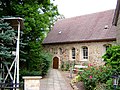
St. Jakobi Church
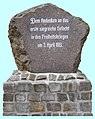
Memorial stone 1813


Individual evidence
- ^ City of Gommern - residents' registration office (ed.): Population figures for the unit municipality of Gommern - as of December 31, 2017 . January 28, 2019.
- ↑ Map services of the Federal Agency for Nature Conservation ( information )
- ↑ StBA: Changes in the municipalities in Germany, see 2005
Web links
- Dannigkow on gommern.de
- Recreation area at Lake Balaton