Gommern
| coat of arms | Germany map | |
|---|---|---|

|
Coordinates: 52 ° 4 ′ N , 11 ° 50 ′ E |
|
| Basic data | ||
| State : | Saxony-Anhalt | |
| County : | Jerichower Land | |
| Height : | 52 m above sea level NHN | |
| Area : | 159.98 km 2 | |
| Residents: | 10,488 (Dec. 31, 2019) | |
| Population density : | 66 inhabitants per km 2 | |
| Postcodes : | 39175 (Menz, Wahlitz) , 39245 (Dannigkow, Gommern) , 39264 (Dornburg, Lübs, Prödel) , 39279 (Ladeburg, Leitzkau) , 39291 (Karith, Nedlitz, Vehlitz) |
|
| Primaries : | 039200 (Gommern, Dannigkow, Karith, Vehlitz, Wahlitz) 039224 (Nedlitz) 039241 (Ladeburg, Leitzkau) 039242 (Dornburg, Lübs, Prödel) 039292 (Menz) |
|
| License plate : | JL, BRG, GNT | |
| Community key : | 15 0 86 055 | |
| LOCODE : | DE MMR | |
City administration address : |
Platz des Friedens 10 39245 Gommern |
|
| Website : | ||
| Mayor : | Jens Hünerbein (independent) | |
| Location of the city of Gommern in the Jerichower Land district | ||
Gommern is a unified municipality and city in the district of Jerichower Land in Saxony-Anhalt .
geography
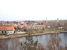
Gommern is located on the Ehle , a tributary of the Elbe . To the south-east there is an extensive forest area with a larger recreational area on the road to Schönebeck . The state capital Magdeburg is 16 kilometers away, the district town of Burg 31 kilometers away.
In terms of natural space , the place belongs to the Zerbster Land , an arable, open cultural landscape and 536 km² main unit of the superordinate main unit group of the Fläming in the north German lowlands . The Zerbster Land forms the southwestern roof of the Fläming to the Elbe and belongs to the catchment area of this river.
The unitary community of Gommern includes 11 localities and districts with small settlements:
|
The town of Gommern includes the small settlements Heinrichsthal, Neugut, Pfingstwiese, Piehles Mühle, Rittersberg, Schenkenteich, Waldschlößchen and the district Vogelsang with its forester's house, Neue Mühle and Pilm.
history
The prince's grave of Gommern , discovered in 1990 on the Gerstenberg, indicates that the Gommern area was settled in the 3rd century .
In the deed of foundation for the Diocese of Brandenburg from 948, Gommern is officially mentioned for the first time with its place name Guntmiri. At that time it had the position of a castle award and was given as such by Otto I to the Moritzkloster in Magdeburg in 965 . In the 12th century Gommern came under the rule of Albrecht the Bear and thus became part of the Duchy of Saxony . It thus formed an enclave in the Magdeburg-Brandenburg area of influence. From 1283 to 1308 Gommern had to be pledged to the Archdiocese of Magdeburg and from 1418 to 1539 to the city of Magdeburg. In the 12th century, the Burgward developed into a village settlement along a road at the foot of the castle. In 1192 a “city” church is mentioned. In 1275 the Ascanians began building a fortified castle.
With the formation of the Saxon districts in the 16th century, Gommern became an administrative district , to which 16 other places in the area belonged, to the district of Belzig. At that time the place had already achieved a certain prosperity through the exploitation of the quarries in the south. In 1578, Elector August von Sachsen had the remains of the now dilapidated castle demolished, with the exception of the keep , and a renaissance castle, the Gommern moated castle, which still exists today , was built from the building materials from the Plötzky monastery , which was also demolished . In 1607, almost 20 percent of the population was killed by the plague . Gommern with the districts Karith and Vehlitz was affected by the persecution of witches from 1584 to 1704 . 16 people were involved in a witch trial , two died in prison after being tortured. Margarethe Wödin (1584) and Gertraut Gensicke (1632) were burned.
During the Thirty Years War , Gommern was largely destroyed by the imperial troops under Pappenheim , but reconstruction began as early as 1635. For the craftsmen recruited by the Saxon Elector Johann Georg II to revive the place, a new settlement was built with the Georgsstadt. In 1666 Gommern was granted market rights, which gave it the status of a market town, and at the end of the 17th century the number of inhabitants had increased again to 600. In 1713 city charter was granted and in 1742 Gommern received a pharmacy privilege from the elector.
When, after Napoleon I's victory over Prussia, his West Elbe territories were converted into the Kingdom of Westphalia under Napoleon's brother Jérôme, Saxony, allied with the French, left the office of Gommern to Jérôme on April 9, 1808 . The office became a canton and the city became the canton capital. It was the only French-owned area east of the Elbe. With the conquest of Gommern by Prussian troops on April 30, 1813, the French interlude and membership of Saxony ended. With the Prussian district reform in 1818, the former Gommern office was assigned to the Jerichow I district with the district town of Burg.
With the expansion of the Chaussee Magdeburg - Dessau and the opening of the parallel railway line in 1874, Gommern found itself in a convenient location. By the end of the 18th century there was a modest industrial infrastructure with weaving mills, breweries and a tobacco factory. With the economic upswing in Germany in the last quarter of the 19th century, new businesses also settled in Gommern with a cardboard box factory, a sugar factory, a shoe factory and several mills. In addition, Gommern also became an important trading center for wood and grain. The quarries south of the city, which had been in operation for a long time, were exploited to an even greater extent. For this purpose, a small railway line to Pretzien was set up in 1890 . With 800 employees, the quarries became the largest employer in the region. However, social conflicts were inevitable, and between 1890 and 1911 there were several strikes by quarry workers. In the Reichstag elections of 1903, 25 percent of those eligible to vote in Gommeran voted for the Social Democratic candidate. In 1899, the Vogelsang sanatorium was built in the nearby forest, where women suffering from tuberculosis were initially treated. It was partially destroyed during the bombing raids on Magdeburg in 1944. Outbuildings such as the kitchen and laundry were affected. During the founding period , the cityscape changed considerably due to the new construction of representative town houses.
During the time of National Socialism , local citizens became involved against the regime, such as the communist teacher Martin Schwantes , who organized the resistance in conjunction with the resistance group around Anton Saefkow after a prison and concentration camp imprisonment in the Magdeburg district . After the Second World War , the sugar factory was dismantled as Soviet reparations . In 1952, as part of the GDR regional reform , the city was incorporated into the newly created Burg district. After oil and natural gas were discovered in the Altmark , Gommern was also able to benefit from them, because in 1951 a plant for oil and natural gas exploration was set up here, in which up to 2100 people found employment. Over 700 new apartments were built. At the same time, the quarries were shut down and converted into a local recreation area.
The German reunification brought deep cuts in the industrial structure of Gommern. The petroleum and natural gas plant had to cease operations and an industrial park with several small businesses was created on its wide industrial site. As a result of the renewed regional reform Gommern came to the district of Jerichower Land .
Incorporations
By incorporating numerous neighboring villages, the population increased by almost 78 percent. On January 1, 2005, the city of Gommern expanded to include the nine former communities of Dannigkow, Dornburg, Karith, Ladeburg, Leitzkau, Menz, Nedlitz, Vehlitz and Wahlitz. On January 1, 2008, Prödel was added. Lübs followed on January 1, 2009.
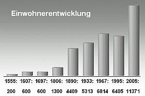
Population development
politics
City council
The city council elected on October 9, 2005 consisted of 28 members and the mayor ( SPD 33.7%, FDP 24.0%, CDU 23.5%, FWGL 9.4% and Die Linke 9.3%).
The city council elected on May 25, 2014 is composed as follows:
| CDU | 30.7% | 9 seats |
| FWGL | 24.8% | 7 seats |
| SPD | 18.5% | 5 seats |
| The left | 11.1% | 3 seats |
| FDP | 6.7% | 2 seats |
| FWGE | 5.2% | 1 seat |
| Green | 2.4% | 1 seat |
mayor
- 1945: Otto Dit (1893–1950)
- 1945: Eberhard Nachmann (until July 27, 1945)
- 1945–?: Walter Krenzke (1907–1986)
- 1945–1955 Otto Theodor Alfred Hensel (1889–1966)
- 2005–2012: Wolfgang Rauls ( FDP )
- 2012–: Jens Hünerbein (independent)
coat of arms
Blazon : "In blue a golden oblique left bar, accompanied by two six-pointed golden stars."
The crossbar stands for the river Ehle, which separates the Gommeran old town from the new town (symbolized by the two stars).
Gommern obtained the right from the state government of Saxony-Anhalt to continue to use his coat of arms, which had been established in a historical baroque shield.
flag
The city of Gommern has the following flag: blue / yellow / blue striped with the city's coat of arms on the wider yellow median strip.
Town twinning
- Königslutter , Lower Saxony , since 1990
- Saint-Jean-de-la-Ruelle , France , since 1996
Attractions
In addition to the Protestant St. Trinity Church , which was built from 1692, the Gommern moated castle, which dates back to the Middle Ages , shapes the image of the city.
At his parents' house in the street named after him, a memorial plaque commemorates the teacher Martin Schwantes who was active in the resistance against the National Socialist regime and who was murdered in Brandenburg-Görden in 1945 .
In the local cemetery there is an honorary grave that was erected after the Second World War for 41 prisoners of war and forced laborers who were deported to Germany during the war, as well as for German resistance fighters against National Socialism.
In 1960, a memorial stone was erected in the former Jewish cemetery on Wiesenstrasse in memory of the Jewish victims of the Shoah .
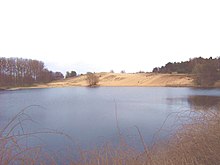
Also noteworthy are the Gommern rock garden , the Fuchsberg shifting dune and the Kulk lake at the foot of the dune . In the forest south of Gommern is the Heinrichstal lake and the Gommern Heidegarten .
A brick building built in 1901 as a donation by the Jewish honorary citizen Moritz Manheimer in Manheimerstraße 12 named after him was used as an after-work and senior citizens' home from 1955 to 1993, then until 2011 as a youth hostel of the German Youth Hostel Association .
The Catholic Herz-Jesu-Kirche was built in 1903 in the neo-Gothic style and has the highest tower in Gommern.
For further sights see:
Transport links
In Gommern, the B184 Magdeburg - Zerbst / Anhalt - Dessau-Roßlau - Bitterfeld-Wolfen - Leipzig and the B246a Wanzleben - Schönebeck (Elbe) - Möckern - Burg (near Magdeburg) cross . The B184 is routed past Gommern via a bypass.
Gommern has a train station on the Biederitz – Trebnitz line and is served hourly by regional express trains on the Magdeburg - Zerbst - Dessau - Bitterfeld - Leipzig line, with individual trains running to Lutherstadt Wittenberg .
In addition to the Gommern train station, there are other stations in the districts of Wahlitz, Prödel and Lübs, where almost all trains that stop in Gommern currently stop. All other districts as well as Burg and Möckern can be reached by bus.
Personalities
- Jacob Wächtler (1638–1702), was superintendent in Gommern from 1679 to 1687
- Christian August von Anhalt-Zerbst (1690–1747), Prussian Field Marshal General
- Samuel Hahnemann (1755–1843), doctor and founder of homeopathy; from 1782 to 1785 physicist in the Gommern office
- Valentin Manheimer (1815–1889), one of the founders of the Berlin clothing industry
- Moritz Manheimer (1826–1916), businessman, benefactor; Honorary citizen of Gommern
- Leonhard Fendt (1881–1957), Protestant pastor in Gommern
- Otto Theodor Alfred Hensel (1889–1966), honorary citizen; Mayor of Gommern 1945–1955
- Martin Schwantes (1904–1945), teacher and communist; attended primary school in Gommern
- Karljosef Schattner (1924–2012), architect, master builder in Eichstätt, visiting professor in Zurich
- Uwe Boegelsack (1939–2017), politician (SED), Minister for Electrical Engineering and Electronics
- Martin Hoffmann (* 1955), former German soccer player and coach
- Karla Schulze (* 1960), politician (Bündnis 90 / Die Grünen), member of the state parliament (1990-94)
- Klaus Petersen , honorary citizen; former mayor of Gommern
- Dagmar Mestchen (* 1963, now Dagmar Fischer), multiple GDR table tennis champion
literature
- Berent Schwineköper (Hrsg.): Handbook of the historical sites of Germany . Volume 11: Province of Saxony Anhalt (= Kröner's pocket edition . Volume 314). 2nd, revised and expanded edition. Kröner, Stuttgart 1987, ISBN 3-520-31402-9 .
- Gommern. In: Johann Heinrich Zedler : Large complete universal lexicon of all sciences and arts . Volume 11, Leipzig 1735, column 165.
Web links
- Link catalog on Gommern at curlie.org (formerly DMOZ )
Individual evidence
- ↑ State Statistical Office Saxony-Anhalt, population of the municipalities - as of December 31, 2019 (PDF) (update) ( help ).
- ↑ Map services of the Federal Agency for Nature Conservation ( information )
- ^ Main statute of the city of Gommern. March 19, 2015, accessed June 16, 2017 .
- ↑ a b Local area directory for the state of Saxony-Anhalt (directory of the municipalities and parts of the municipality), as of January 2014, State Statistical Office Saxony-Anhalt, Halle (Saale), 2016
- ↑ Manfred Wilde : The sorcery and witch trials in Saxony. Cologne / Weimar / Vienna 2003, pp. 502–506
- ↑ StBA: Changes in the municipalities in Germany, see 2005
- ↑ StBA Area: changes from 01.01. until December 31, 2008
- ↑ StBA: Area changes on 01/01/2009
- ↑ Overall result of the 2014 city council election for the Gommern community. Retrieved July 13, 2015 .
- ↑ WE


