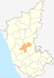
Davanagere (district)
| Davanagere District ದಾವಣಗೆರೆ ಜಿಲ್ಲೆ |
|
|---|---|

|
|
| State | Karnataka |
| Division : | Bangalore |
| Administrative headquarters : | Go away |
| Area : | 5,918 km² |
| Residents : | 1,946,905 (2011) |
| Population density : | 329 inhabitants / km² |
| Website : | Go away |
The Davanagere district ( Kannada : ದಾವಣಗೆರೆ ಜಿಲ್ಲೆ ; also: Davangere ) is a district of the Indian state of Karnataka . The administrative center is the eponymous city of Davanagere .
geography
The Davanagere district is located in central Carnataka. Neighboring districts are Chitradurga in the southeast, Chikmagalur in the south, Shimoga in the southwest, Haveri in the northwest and Bellary in the northeast.
The area of the Davanagere district is 5,918 km². The district area belongs to the southern part of the Dekkan Plateau and presents itself as a plateau from which isolated mountains rise. The Tungabhadra River flows through the western part of the district and in parts forms the border with the Haveri district.
The Davanagere district is divided into the six taluks Channagiri, Davanagere, Harirar, Harpanahalli, Honnali and Jagalur.
history
During the British colonial period , Davanagere belonged to the princely state of Mysore . After Indian independence, Mysore joined the Indian Union in 1949. Through the reorganization of the Indian states, the area of Davanagere in 1956 became part of the state of Mysore (renamed Karnataka in 1973 ) after the language borders of the Kannada . In 1997, the Davanagere district was dissolved as an independent district from the Chitradurga district.
population
According to the 2011 Indian census, the Davanagere district has 1,946,905 inhabitants. Compared to the last census in 2001, the population grew by 8.7% and thus more slowly than the average in Karnataka (15.7%). The population density of 329 inhabitants per square kilometer corresponds to the average of the state (319 inhabitants / km²). 32.3% of the district's residents live in cities, while Karnataka's average is 38.6%. At 76.3%, the literacy rate is also close to the state average (76.1%).
According to the 2001 census , Hindus make up the majority of the residents of Davanagere district with 85.6%. There is also a Muslim minority of 12.7%. The Indian census classifies 11.7% of the district population as members of the tribal population (see Adivasi ). These are almost exclusively members of the Naikda tribe .
Cities

| city | Population (2001) |
|---|---|
| Channagiri | 18,517 |
| Go away | 363.780 |
| Harihar | 75,042 |
| Harpanahalli | 41,889 |
| Honnali | 15,574 |
| Jagalur | 14,741 |
Attractions
The district is rather poor in cultural or historical sights; The Chalukya temples of Neelagunda and Bagali as well as the Hoysala temple of Harihar should be emphasized . The modern church of Harihar Our Lady of Health with its pagoda-like tower is also worth mentioning.
Web links
Individual evidence
- ↑ Census of India 2011: Provisional Population Totals: Data Sheet (PDF; 1.7 MB) and Population and decadal growth rate by residence Persons. (PDF; 1.3 MB)
- ^ Census of India 2001: Basic Data Sheet. District Davanagere (14), Karnataka (29). (PDF; 54 kB)
- ↑ Census of India 2001: Population, population in the age group 0-6 and literates by sex - Cities / Towns (in alphabetic order) ( Memento from June 16, 2004 in the Internet Archive )