Delliehausen
|
Delliehausen
City of Uslar
|
||
|---|---|---|
| Coordinates: 51 ° 41 ′ 4 " N , 9 ° 44 ′ 36" E | ||
| Height : | 246 (200-457) m | |
| Residents : | 541 (Dec. 31, 2019) | |
| Incorporation : | March 1, 1974 | |
| Postal code : | 37170 | |
| Area code : | 05573 | |
|
Location of Delliehausen in Lower Saxony |
||
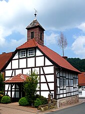
Delliehausen is a district of the city of Uslar with 541 inhabitants. It consists of the village of Delliehausen and the settlement of Haje.
location
The place is located on the southern foothills of the Solling at an altitude of about 250 m above sea level. NN in the valley of the Rehbach . The core city of Uslar is 12 kilometers to the west, the district town of Northeim 25 kilometers to the east, Göttingen 20 kilometers to the southeast and the Lower Saxony state capital Hanover a good 73 kilometers to the north (all information as the crow flies).
The license plate number of the village in the Northeim district is NOM and the postcode is 37170.
history
The area around the place was already populated in the Stone Age, which is proven by some weapons finds. In 1293 Delliehausen was mentioned for the first time in a document in which Ludolf V. von Dassel donated his property in Deligehusen to the Steina monastery. An earlier mention of a place Daillanhus in the Vita Meinwerci cannot be safely assigned to today's place Delliehausen. Delliehausen part of the basic rule of the monastery Steina , but went on in 1366 to the Dukes of Braunschweig, a grand here Vorwerk built with extensive land holdings. Delliehausen was mainly a forest worker - and charcoal burner village , which a museum-operated charcoal kiln still bears witness to and what is reflected in the coat of arms .
In 1585 41 families, 3 farm workers, 21 kötner and 7 housebuilders lived in "Dellinghusen". According to the topographical survey of the Electorate of Hanover in 1764/86, the place has around 35 households. The houses were on both sides of the Rehbach. The Vorwerk was dissolved around 1800. From today's district of Haje (opened for settlement in 1810) only the forester's house was recorded. The so-called "Neustadt" was not built until a hundred years later around 1900 south of the old village on the road to Volpriehausen.
From 1885 to 1911, lignite was mined near the site in open-cast mining to a depth of around 50 meters. Today's mountain lake emerged from this open-cast mine . Since March 1, 1974, the previously independent community has been part of the then newly founded community of Uslar.
Infrastructure
- Road: Only a side road leads to Delliehausen, which branches off in Volpriehausen from the federal road B241 , which leads from Beverungen via Hardegsen to Nörten-Hardenberg . The next motorway junctions are at Göttingen, Nörten-Hardenberg and Northeim on the A7 .
- The Solling Railway runs from Ottbergen to Northeim about two kilometers away . The next regional train stations or stops are in Volpriehausen, Uslar- Allershausen or Hardegsen on the railway line. The nearest ICE / IC train station is also in Göttingen .
- Air traffic: There is a small sports airfield near Uslar.
tourism
In Delliehausen there are over 60 guest beds in a hotel, a guest house and five holiday apartments. There is a campsite by the mountain lake above Delliehausen on the Haje.
See also
literature
- Gustav Bierkamp, Armin Reuse: Chronicle of Delliehausen in Solling. From the history of the village of Delliehausen since 1974 a district of the city of Uslar. 1016-1980 , published by the Solling-Heimat-Verein Delliehausen, self-published, Uslar 1980.
Web links
Individual evidence
- ↑ a b Population data of Uslar including districts, published by the city of Uslar (status: December 31, 2019, accessed on April 6, 2020)
- ^ Federal Statistical Office (ed.): Historical municipality directory for the Federal Republic of Germany. Name, border and key number changes in municipalities, counties and administrative districts from May 27, 1970 to December 31, 1982 . W. Kohlhammer GmbH, Stuttgart and Mainz 1983, ISBN 3-17-003263-1 , p. 214 .


