
Derinkuyu
| Derinkuyu | ||||
|
||||
| Basic data | ||||
|---|---|---|---|---|
| Province (il) : | Nevşehir | |||
| Coordinates : | 38 ° 22 ' N , 34 ° 44' E | |||
| Height : | 1300 m | |||
| Residents : | 10,789 (2018) | |||
| Telephone code : | (+90) 384 | |||
| Postal code : | 50 700 | |||
| License plate : | 50 | |||
| Structure and administration (as of 2019) | ||||
| Structure : | 8 mahall | |||
| Mayor : | Bülent Aksoy ( AKP ) | |||
| Postal address : | Namık Kemal Mah. Ataturk Cd. No: 17 50700 Derinkuyu / Nevşehir |
|||
| Website: | ||||
| Derinkuyu County | ||||
| Residents : | 20,786 (2018) | |||
| Surface: | 473 km² | |||
| Population density : | 44 inhabitants per km² | |||
| Kaymakam : | Mert Kumcu | |||
| Website (Kaymakam): | ||||


Derinkuyu ( Turkish for deep shaft ) is a small town and capital of the district of the same name ( İlçe ) in the Central Anatolian province of Nevşehir . The place is located 29 km south of the provincial town Nevşehir in Cappadocia directly on the D765 trunk road.
geography
The district was formed in 1960 and is located in the south of the province. It borders in the north-west on the Acıgöl district , in the north on the central district of the provincial capital and in the north-east on the district of Ürgüp . The border is formed by the Niğde Province in the south and the Kayseri Province in the east .
In addition to the district town with Yazıhüyük (3,606 inhabitants), the district consists of another municipality ( Belediye ). Furthermore, seven villages ( Köy ) with an average of 913 inhabitants belong to the district:
- Suvermez (1,627)
- Kuyulutatlar (1,141)
- Çakıllı (1,116)
- Özlüce (964)
- Dogala (748)
- Til (575)
- Güneyce (220 pop.)
history
The place is known for its large former underground city with many floors. Already in the 4th century BC The place was mentioned in the 3rd century BC, a continuous settlement is proven by coin finds that cover the period from the Roman Empire to the Seljuks .
In the village, 100 meters south of the entrance of the underground city, there is a remarkable Armenian basilica from 1858. The massive three-aisled building is surrounded by a wall and has a free-standing bell tower on the north side. In the 20th century the building was taken over by Greek Christians , after their expulsion it was used as a mill and warehouse, today a small museum is housed there.
According to the city seal, the place was raised to a municipality (Belediye) in 1930.
gallery

Cruciform church on the seventh floor of the Derinkuyu underground city
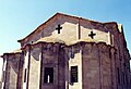
Church in Derinkuyu

Aisle of the basilica

Deep ventilation well of Derinkuyu underground city


literature
- Michael Bussmann, Gabrielle Tröger: Turkish Riviera, Cappadocia . Michael Müller Verlag, Erlangen 2003, ISBN 3-89953-108-6
- Peter Daners, Volker Ohl: Cappadocia. Dumont, 1996, ISBN 3-7701-3256-4
Web links
Individual evidence
- ↑ a b Türkiye Nüfusu İl ilçe Mahalle Köy Nüfusları , accessed on July 12, 2019
- ↑ a b Wolfgang Dorn: Turkey - Central Anatolia: between Phrygia, Ankara and Cappadocia . DuMont, 2006, ISBN 3770166167 , page 284 ( on GoogleBooks )
- ↑ Ömer Demir: Cappadocia: Cradle of History . Extended 3rd edition. Ajans-Türk Publ. & Printing, Ankara 1988, p. 9
