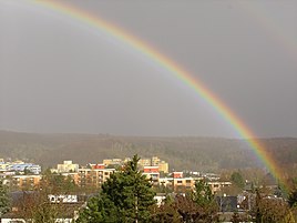
Deutschhof (Schweinfurt)
|
Deutschhof
Coordinates: 50 ° 4 ′ 3 ″ N , 10 ° 15 ′ 11 ″ E
|
|
|---|---|
| Height : | 250-311 m above sea level NN |
| Area : | 1.27 km² |
| Residents : | 6018 (December 31, 2015) |
| Population density : | 4,739 inhabitants / km² |
| Postal code : | 97422 |
| Area code : | 09721 |
|
District Deutschhof (Districts 43-47)
|
|
|
Deutschhof
with Schweinfurt Rhön |
|
The Deutschhof (place name: am Deutschhof ) is a district of the independent city of Schweinfurt in Lower Franconia . It is listed in the statistics of the city of Schweinfurt as district 43 to 47. The Deutschhof is the highest district of Schweinfurt, it was built from 1970 on land owned by the Schweinfurt Hospital Foundation .
geography
location
The Deutschhof is located in the northeast of the urban area and borders in the south on the northeastern part of the city (district 42), in the southwest on the district of Hochfeld / Steinberg (district 41), in the west on the state road St 2280 to Bad Königshofen (into town Deutschöfer Straße) and the Hundertäcker sports park (to district 41), to the north to the city forest ( Schindelholz and Sattlerau ) and to the east to Höllental .
topography
The Deutschhof is located in the Schweinfurt Rhön on a hill above the Höllenbach . The highest built-up area in the city is on Nußbergstrasse, on the northern edge of the district, at 311 m above sea level. NN.
Statistical districts
The city of Schweinfurt subdivided the district into five districts for statistical purposes:
- 43 Deutschhof-Süd
- 44 Deutschhof-Mitte
- 45 Deutschhof-Ost , with the historic Gut Deutschhof
- 46 Deutschhof-Nord
- 47 Deutschhof-Zeilbaum
Urban climate
The Höllental , which runs east of the Deutschhof, is a cold air supply alley to the city.
A climatic divide runs through the urban area, as the summer-hot Main Franconian plates merge into the Schweinfurt Rhön. In earlier decades, for example, there was a 20 to 30 cm high layer of snow on the northern edge of the Deutschhof, while there was hardly any snow in the port 100 m below .
history
Already in the 8th century there was a supra-regional connection from Schweinfurt to Erfurt, roughly along or directly on Deutschhöfer Straße or Staatsstraße 2280 (see: Location ) .
Gut Deutschhof
Before the development of the Deutschhof district, Gut Deutschhof was located here, an estate whose predecessor was first mentioned in a document in 1497. In 1437, the council of the city of Schweinfurt acquired the estate with the field name Deutschfeld together with neighboring lands and villages from the Teutonic Order for a total of 18,000 guilders . In 1519 the Schweinfurt Hospital Foundation bought the area including the estate. At the gate of the manor you can still see the seal of the foundation - a double cross with the dove of the Holy Spirit. For German field left and right, the land belonged to today's German Field road in Northeastern District . The manor buildings, which were destroyed several times by war and fires and which lay lonely in front of the city, were first protected by a wall in the 16th century . The manor's buildings still exist today.
From 1970 the new Deutschhof district was built on the estate's land. For the hospital foundation, lands in Grettstadt were purchased as replacement for a new manor. The agricultural use of the remaining undeveloped meadows and fields around the Deutschhof gave up the estate in 1977. The manor buildings remained abandoned until 1982. The new owner of the building was now the Evangelical-Lutheran Church Community, which inaugurated a new kindergarten here in 1984. The community hall opened in the former barn in 1986 and apartments were built in the former horse stable by 1996. In 2008 the church hall in the former granary was inaugurated.
district
In an urban planning competition , an Aachen planning group with the architect Erich Kühn prevailed. At the highest point came the tallest houses, as in the other new districts in the northeast of Schweinfurt, and single-family houses are grouped around the slopes on the outside.
The new district Deutschhof was planned for 14,000 residents. As a result of the new trend away from apartment buildings and towards single-family homes, planning was carried out accordingly and the number of residents reduced to 8,000. The district was completed in the early 1990s. Due to the changed social conditions with more single households and a higher need for living space per person, the district now only has 6,000 inhabitants. At the turn of the millennium, the new Zeilbaum district was added on the southern edge of the district (see: Zeilbaum ).
Late repatriates
In the 1980s, many ethnic German repatriates moved to the apartment blocks in the core of the Deutschhof, which became a social hotspot. The market square was called Red Square . When juvenile delinquency increased increasingly in the early 1990s, Aktion Gern beiheim in Schweinfurt was launched. A youth club was set up in the basement of the St. Maximilian Kolbe community center.
The young people at the time are now well integrated. There is nothing left of the former unrest today, there are no more district gangs or gangs. According to the police, the crime rate today is the same as in other parts of the city.
Election result
In the 2017 Bundestag election , the AfD achieved the best result of all Schweinfurt districts with 22.8% at Deutschhof.
Districts
Simple residential areas can be found in a smaller core area of the district with apartment blocks, in the streets Am Schöttlein and Am Haag . The vast majority of the Deutschhof has medium-sized residential areas and the Zeilbaum has good residential areas. In this evaluation, the exclusive hillside locations for single-family houses above the Höllental , with a view of the mountain forests of the Schweinfurt Rhön , are not taken into account.
Deutschhof-South / Middle / East
(Districts 43 - 45)
| Status December 31, 2015 |
Deutschhof-Süd / Mitte / Ost (districts 43 - 45) |
The entire Schweinfurt area |
|---|---|---|
| German | 65.9% | 70.7% |
| Dual nationals | 26.5% | 16.1% |
| Foreigners | 7.6% | 13.2% |
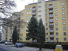
The core area of the Deutschhof, which has been built with up to eight-storey residential houses since 1970, has beautifully located single-family home areas on the eastern edge above the Höllental with a view of the Schweinfurt Rhön. In terms of numbers, however, the residents of the apartment buildings, which were originally built as well-equipped apartments for the German bourgeoisie, predominate by far.
Due to the demographic decline in the population and the large number of late repatriates arriving in the 1980s, the residential area outside of the single-family houses owned by the family underwent a complete social change and became the Schweinfurt focus area for Russian Germans . This can also be clearly seen in the population statistics, due to the high number of dual nationals .
Deutschhof-North
(District 46)
| Status December 31, 2015 |
Deutschhof-Nord (District 46) |
The entire Schweinfurt area |
|---|---|---|
| German | 79.4% | 70.7% |
| Dual nationals | 14.6% | 16.1% |
| Foreigners | 6.0% | 13.2% |
The district around the ring-shaped Nußbergstrasse lies entirely in the Schweinfurt Rhön and is surrounded on three sides by forest. With over 300 m above sea level in the north, it is the highest district in the city. It is one of the newer areas of the Deutschhof, with a higher standard. Despite its peripheral location, it is easily accessible by the city bus and frequented by buses.
In the northern forest are the remains of a military training area , which was never used because the First World War broke out when it was completed . There are tall trees in the trenches today.
The quarter borders on the city forest: in the east on the shingle wood on the steep slope to the Höllental and in the north on the Sattlerau. The quarter is thus directly connected to the dense network of hiking trails in the Schweinfurt Rhön .
Zeilbaum
(District 47)
| Status December 31, 2015 |
Deutschhof-Zeilbaum (District 47) |
The entire Schweinfurt area |
|---|---|---|
| German | 86.7% | 70.7% |
| Dual nationals | 11.4% | 16.1% |
| Foreigners | 1.9% | 13.2% |
In addition to the Deutschhof district in the narrower sense, the last major residential area in the city to date has been redeveloped not far from the Hochfeld , the Zeibaum with the development plans east (1999), north (2000) and south (2001). He owns a small shopping center and a similar, bourgeois social structure as the Hochfeld.
The Zeilbaum located on Seinäjokipark and German field cemetery, also naturnah above the recreation area Höllentalbahn how far to the conservation area Mainleite extends. From the Zeilbaum you can look over the Schweinfurt basin to the Steigerwald .
The quarter consists of six apartment buildings along Elsa-Brändström-Straße, 100 single-family houses and 30 terraced houses. The Zeilbaum was the first Schweinfurt building area for which there were increased ecological regulations, with the preservation of hedges and trees, planting requirements, the creation of ecological areas and flat roof greening. In addition, a 4,000 square meter orchard meadow had to be created in the Höllental at the expense of the client.
The name Zeilbaum probably comes from the Old High German Zila or Middle High German Zile , for line or row , which is why the field name probably denoted a row of trees.
Citizens' association and parish fair
The Deutschhof Citizens' Association was founded in December 1979. He organizes the Deutschhof Kirchweih, which takes place at the beginning of July in the neighboring wildlife park on the oaks .
See also: Schweinfurt, Citizens' Associations
Infrastructure
In the center of the district is the car-free market square, a small, partially deserted business center. In the district there is the Catholic Church of St. Maximilian Kolbe with a youth center and two kindergartens. The Evangelical Lutheran parish church of St. Lukas on the neighboring Hochfeld opened a community center in the former Gut Deutschhof in 1982.
The Deutschhof is connected to the city bus network of Stadtwerke Schweinfurt by line 52. In the southeast, above the Höllental , is the city's second largest cemetery, the Deutschfeldfriedhof.
Wildlife park on the oaks and the Hundertäcker sports park border the district in the southwest.
Web links
Individual evidence
- ↑ Measured using the BayernAtlas
- ^ Population register-based population
- ↑ Overview map of the districts. Retrieved December 19, 2017 .
- ↑ Topographic map 1: 50,000, sheet L 5926 Schweinfurt, State Office for Surveying and Geoinformation Bavaria, 8. Aflg. 2006
- ↑ a b c mainpost.de: Deutschhof: “Diversity in Unity”, January 24, 2018. Accessed April 24, 2020 .
- ↑ a b c Main-Post: "Living in the manor house and in the cattle barn on Gut Deutschhof", February 11, 2019. Accessed on February 11, 2019 .
- ↑ focus.de: Election Facts: 22.8% in the Deutschhof district vote AfD , 25 September 2017
- ↑ SW1.news: "Residential real estate market report for Mainfranken der HypoVereinsbank", June 8, 2018. Accessed on February 13, 2019 .
- ↑ a b c Population register-based
- ↑ a b c mainpost.de: City districts in portrait: Zeilbaum or house builders paid for orchards, 29 August 2017. Accessed on 29 April 2020 .
- ↑ Plan of the Mainleite landscape protection area. Retrieved April 29, 2020 .
- ↑ Deutschhof-Kirchweih: Have a beer with Lasse and the Unicorn, July 7, 2019. Accessed April 20, 2020 .


