
City center (Schweinfurt)
|
Downtown
Coordinates: 50 ° 2 ′ 37 ″ N , 10 ° 13 ′ 34 ″ E
|
|
|---|---|
| Height : | 220 m above sea level NN |
| Area : | 1.67 km² |
| Residents : | 10,814 (Dec 31, 2015) |
| Population density : | 6,475 inhabitants / km² |
| Postcodes : | 97421, 97422 |
| Area code : | 09721 |
 City Center District (Districts 11-13)
|
|
 Palace of Justice
|
|
The city center is a district of the independent city of Schweinfurt in the Bavarian administrative district of Lower Franconia . The city center is listed as district 12 and 13 in the statistics of the city of Schweinfurt. It is unclear whether the district 11 Altstadt also counts as part of the city center (see: Altstadt ). This article only covers Districts 12 and 13.
location
The city center is bordered in the south by the Main , in the west by Friedrich-, Georg-Schäfer-, Moritz-Fischer- and Nikolaus-Hofmann-Strasse and in the north by Friedhofstrasse. The eastern demarcation of the city center district is uncaring (see: Article introduction). The Schweinfurt Mitte DB stop is located in the south of the city center .
| Northwest district | Garden city | Northern part of the city |
|
Bergl musicians' quarter |
.svg)
|
Old town |
| Oberndorf | Harbor West | Hafen-Ost |
historical overview

In contrast to many other countries, the city center reflects the typical urban development of German cities. While the old town was laid out in the 12th century and then expanded to the west in a second ring up to today's ramparts, there was a standstill for many centuries, which still outlasted the Biedermeier period and the construction of the railway . When the development was still almost entirely within the city walls, 2 km to the west, surrounded by fields, the main train station was laid out in 1874 and only towards the end of the 19th century the wall ring was broken through and the Ludwigsvorstadt was built.
During the Second World War , 60% of the city center was preserved despite 22 bombing attacks, due to the city's strong air defense (see: Schweinfurt, Moderne ).
Social structure
The inner city was a typical working-class district until the post-war decades . Guest workers have moved in since the 1960s , especially from Turkey , which is why the city center has a high proportion of the population with a migration background (see: the following statistics). Recently, like elsewhere, investors are discovering the advantages of the location close to the center and the city center is experiencing redensification and upgrading.
Districts
In the city center, block perimeter development predominates. In the city area with authorities and commercial buildings, otherwise with residential buildings and in the main streets, especially Luitpoldstrasse on the ground floor, also with business premises.
Inner City West (western Wilhelminian style district)
(District 12)
history
_SCHWEINFURT_Fichtel_%26_Sachs_Abb.2.jpg)
|
_SCHWEINFURT_Fries_%26_H%C3%B6pflinger_AG_Abb1.jpg)
|
|
|
Fichtel & Sachs AG Plant 1, 1913 Schrammstrasse / Schillerplatz; from 1929 VKF, eastern part
|
Fries & Höpflinger AG main factory, 1913 Schrammstr./Sattlerstr .; from 1929 VKF, western part
|
The Wilhelminian-era district towards the main train station is a classic Westend . Due to the lack of an official city structure, it has many names. Originally (since around 1890) it was called Ludwigsvorstadt . In urban statistics it is called inner city west and in the course of the urban redevelopment west , which was completed in 2009 , it was also called west city . In order to avoid confusion with the northern Wilhelminian-style district (see: Neutorvorstadt ), it is listed here as the western Wilhelminian-era district.
The name Ludwigsvorstadt was completely forgotten and, like the Ludwigstrasse in its area, refers to the layout of the suburb at the time when Schweinfurt belonged to the Kingdom of Bavaria (see: Schweinfurt, Late Modern Times ). The main street of the quarter, Luitpoldstraße, was named after the Bavarian Prince Regent Luitpold (1886–1912). Like almost all streets of the same name in Bavaria, it is located near or in the direction of the train station, where new suburbs were usually created in the early days of the company .

South of the Wilhelminian style quarter, above the banks of the Main , the first development in Schweinfurt was built outside the city walls. In the period after the bridge gate was demolished in 1833 and before the city was connected to the railroad in 1852, the first buildings were built here along the north side of the arterial road to Würzburg (today's Gunnar-Wester-Straße). The district office was also opened here in 1862 .
In 1891 the magistrate decided to create the actual Wilhelminian-style district, but it was not until 1897 that the first clients were found.
The Wilhelminian style district was separated from the Main by an industrial corridor that was 500 m long and around 120 m wide when it was completed in the 1930s . It was bordered in the south by today's Gunnar-Wester-Strasse and in the north by Schrammstrasse. Fichtel & Sachs plant 1 ( rolling bearing production) was built here in the eastern area from 1905 and the main Fries & Höpflinger plant in the west from 1906 . At that time, Sattlerstrasse separated the two plants from one another, as it crossed Schrammstrasse and continued south to today's Gunnar-Wester-Strasse (see: Fries & Höpflinger picture; the street on the left is Sattlerstrasse). The first municipal tram in Bavaria, the Schweinfurt tram, ran through today's Gunnar-Wester-Straße from 1896 to 1921 .
.jpg)
In the course of the reorganization of the German rolling bearing industry in 1929, both plants were merged into the United Ball Bearing Factory , since 1953 SKF GmbH (see: Schweinfurt industrial history, reorganization of the rolling bearing industry ). In this area, Sattlerstrasse has now become the private premises of SKF Plant 1 .
By 2005, the eastern and then the western part of the large factory complex, with the exception of the SKF administration tower, was demolished. This offered a lot of space close to the city center for new government buildings and the Schweinfurt city gallery . One of two expanded, historic Art Nouveau factory gates was set up in the former area of Sattlerstrasse, which has been open to the public again since 2009 (see photo: Urban Redevelopment West and Gentrification ).
Schillerplatz
In addition to factory buildings in the above-mentioned corridor, two buildings were first erected on Schillerplatz in the actual quarter. A hall of a former Evangelical Free Church (Free Christian Congregation) which, according to the land register plan from 1868, already served as a theater and concert hall . Today the district office is located here . Furthermore, from 1846 to 1902, the hospital of the Schweinfurt Hospital Foundation with a park was located in place of the current justice building built in 1905.
The theater was at the beginning of Geldersheimer Weg, which connected the nearby Spitaltor at the end of Schultesstraße, which no longer exists today, with the suburb of Geldersheim . The beginning of the route of the Geldersheimer Weg is still visible today, in the diagonal of the triangular Schillerplatz, which was named because of the theater. After that, the path disappeared completely, as a result of the chessboard-like street grid of the Wilhelminian-era district that was laid out diagonally to it. However, the Geldersheiner Weg still exists today under the same name 1.5 km west of Schillerplatz, as a cycle and footpath to the city limits. Before the development, the hallway of the northern area of the Wilhelminian-style district was called Am Geldersheimer Weg .
- Western Wilhelminian style district

Rüfferstraße,
with the Palace of Justice
(New Baroque 1905)
Luitpoldstrasse,
thinned as a result of war damage,
five-storey redensification since 2016
Luitpoldstrasse,
with a typical corner pub;
Block perimeter development without a front garden zone
Sattlerstrasse, perimeter block development with front garden zone

Ludwigstrasse,
Ludwigschule
( Paul Bonatz 1908)


Description of the neighborhood
| Status December 31, 2015 |
City Center West (District 12) |
The entire Schweinfurt area |
|---|---|---|
| German | 54.9% | 70.7% |
| Dual nationals | 15.7% | 16.1% |
| Foreigners | 29.4% | 13.2% |
The quarter is a typical Westend , which was built on both sides of Luitpoldstraße, a boulevard that leads to the main train station and some of the historic buildings are still preserved. The side streets, with the exception of the southern Friedenstrasse, consist mainly of living space of simple standard, which was built for employees of the Schweinfurt industry. The New Baroque Palace of Justice (1905) was built on the eastern edge . The district, especially in the eastern area, has the character of a metropolitan Wilhelminian style district, with rectangular blocks in perimeter block development , with and without front garden zone, characteristic corner pubs and up to six-storey post-war buildings. About half of the quarter was destroyed in World War II and has the closed mixed development of Wilhelminian style and post-war houses from the 1950s, which is typical for larger German cities.
Apart from the long-defunct Turkish colony of Fichtel & Sachs in Oberndorf , the Wilhelminian-era quarter is the oldest and most traditional Turkish quarter in the city, with a mosque , Turkish shops, bars and clubs. The Turkish fellow citizens are already living here in the third generation, with low unemployment and good income compared to other cities (especially Berlin and the Ruhr area ), as the city has not been de-industrialized .
On the northern edge of the district, on the site of the German gelatine factory destroyed in World War II , the Sternhaus was built in the 1970s , a large apartment complex in the luxury segment with an indoor swimming pool. Today it is home to the senior citizens' residence Wohnstift Augustinum .
Urban redevelopment west and gentrification
The Bavarian State Office for Statistics and Data Processing was completed in 1998 in Schrammstrasse next to the new tax office .
In the course of the construction of a 300-meter-long shopping mall , the ECE Stadtgalerie , with 100 shops and 22,500 m² of retail space, which opened in 2009, large parts of the Wilhelminian - style district were redesigned through the so-called Urban Redevelopment West . The justice building and the former state bank were also thoroughly renovated. On the eastern edge of the quarter, in the ramparts, the art gallery was opened in 1933 in the former Ernst-Sachs-Bad, also in 2009 , with 1,890 m² of exhibition space. With the senior care home Domicil (2018) and the condominiums Luitpold-Terrassen (2019) and Riedel Höfe (2019), major projects in the upscale segment were created. As a result of the numerous measures, the quarter is currently experiencing densification and gentrification .
- Urban redevelopment west
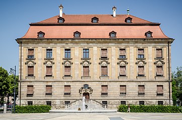
Justice Palace
(New Baroque 1905)
and Schillerplatz (2009)
SKF factory gate
(Art Nouveau 1908) at new location (2009)
Kunsthalle Schweinfurt with arcades
(transition style between historicism and modernism 1932)
and forecourt (2009)
Sattlerstrasse
with the city gallery Schweinfurt (2009)


On the property of the old tax office behind the Palace of Justice from 1905, construction work began in 2019 for a new justice center, which should be completed in 2023. The Palace of Justice is being completely refurbished, and a new main entrance to the justice district leads across Schillerplatz. Together, the construction work should amount to 65 million euros.
Downtown north
(District 13)
Neutorvorstadt (northern Wilhelminian style district)
| Status December 31, 2015 |
City Center North (District 13) |
The entire Schweinfurt area |
|---|---|---|
| German | 63.9% | 70.7% |
| Dual nationals | 13.1% | 16.1% |
| Foreigners | 23.0% | 13.2% |
The name Neutorvorstadt is included on historical city maps from the Wilhelminian era and later, like the name Ludwigsvorstadt (see: Innenstadt-West ), was also completely forgotten. Since the quarter was to be designated as a redevelopment area in 2020 , it has been referred to as the northern Wilhelminian style district.
The former "Neutorvorstadt" is part of the northern inner city and the first planned urban expansion outside the old town . Here the Schweinfurt city wall was broken for the first time outside the area of the five city gates by a new road. Hence the name Neutor , which never existed as a gate, but only as a wall breakthrough to this day. On the cadastral plan from 1868 the road breakthrough and the building lines for the southern part of the Neutorvorstadt up to today's Niederwerrner Straße are already drawn. The suburb project was referred to here as tithe , which goes back to a tithe courtyard of the Haugs monastery in Würzburg , which was once not far from here in the old town (see: old town, Keßlergasse / Lange Zehntstrasse ). The still existing city wall with the ring system (Châteaudun Park) separates the Neutorvorstadt from the old town.
The Neutorvorstadt was laid out as a road cross exactly in the four cardinal directions. Neutorstrasse as the north-south axis forms the main street of the district. The city's major western arterial road , Niederwerrner Strasse, cuts through the district from east to west. The city ring also runs along it in this area, with the (former) federal highways 26, 286 and 303 , which have been downgraded in sections due to new federal highways around Schweinfurt.
Southern Neutorvorstadt
The southern part of Neutorvorstadt was laid out from around 1870 between the ramparts or Schanzen and Niederwerrnerstraße, initially as a residential area on a chessboard-like street layout. The villa district has been continuously densified over the course of time and today has an almost continuous, up to four-storey perimeter block development .
The city's oldest grammar school, the Celtis grammar school , which was founded as the Gustavianum grammar school in Schweinfurt in 1632 on the instructions of the Swedish King Gustav II Adolf, is located in this quarter . The Celtis-Gymnasium is considered an elite school, as the Schweinfurt bourgeoisie is the strongest represented of all the high schools in the city . Students in this grammar school included the Archbishop of Munich and Cardinal Freising Faulhaber and the author of the Bauhaus manifesto, the architect Theodor Fischer . Until the introduction of the euro, there was a branch of the state central bank on Neutorstrasse . Since then, a hotel has been housed in the bank building. Opposite is one of the most successful theaters in Germany, the Schweinfurt City Theater , which opened in 1966 at this location .
- Southern Neutorvorstadt

City wall at the former Neutor
on Neutorstrasse
Villa (late classicism around 1870) Niederwerrner Strasse /
corner of Neutorstrasse
Villa (neo-renaissance 1879)
Gymnasiumstrasse
Celtis-Gymnasium (neo-renaissance 1881)
Gymnasiumstraße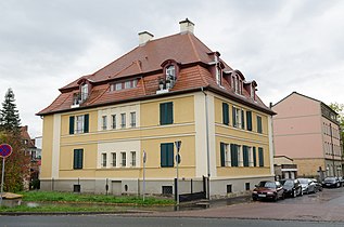
Villa (baroque style 1907)
At the Schanzen


Northern Neutorvorstadt
A little later, a closed Wilhelminian style development was built in the northern area between Niederwerrnerstraße and the main cemetery . It survived the war almost unscathed, as a perimeter block development , mostly with a front garden zone . The west side of Neutorstrasse has been shaped by Turkish life in this northern area since around the 1970s . Since the 2010s , the northern area of the Neutorvorstadt has been experiencing structural upgrading with the first signs of gentrification .
Wilhelmstrasse, Green Market

This quarter (beginning of the 20th century) is the southern area of the northern inner city , is not regarded as a separate quarter and only has the character of a quarter around the Green Market . The main street in this area is Wilhelmstrasse, with shops, bars and two cinemas.
The area around the Green Market next to St. Kilian has a very high proportion of migrants. In order to counteract ghettoization, the northern block from the 1920s was demolished. On the initiative of the then Lord Mayor Gudrun Grieser , Campus 2 of the local University of Applied Sciences was built here to bring student life into the city center. The Campus 2 will remain there until a change in use in 2020 are made (see: University of Applied Sciences, New Building ).
Railway block
Schweinfurt is not a railway town , which is why no district developed in which mainly railway workers live, such as in Grombühl in neighboring Würzburg . A larger railway block from the 1920s, which was built west of the district around the Green Market, on the other side of the city ring, was therefore sufficient. Next to it is the Kilian's Church, which was built for the workers from the Catholic rural population who moved to Protestant Schweinfurt. The Kiliani-Kirchweih (Eisenbahnerkirchweih) takes place in the big yard of the railway block.
Spitalseeplatz
The Spitalseeplatz is located between the above quarter on Wilhelmstrasse and Neutorvorstadt . Here was a small lake in the area around and north of today's Seestraße, with a no longer existing inflow from the valley between the garden city and the Alte Warte . According to the city's plans (as of 2018), the lake is to be rebuilt in roughly the same place. The Spitalseebunker is an elevated bunker that was reactivated in the 1980s . Most of the other bunkers in the city have not been used for any other purpose until today.
A wide road, the Spitalseespange , had been planned along the Spitalseeplatz as a western bypass to the old town since the 1960s , in connection with a 350 m long fourth (then third) Main road bridge over the two arms of the Main and the lock canal. The west bypass should connect to the city ring in the east port . The project was abandoned by the city council in the 1990s (see: Main bridges in Schweinfurt, abandoned project Vierte Mainbrücke ).
literature
- Erich Schneider: Schweinfurt and its monuments - architecture-art-technology . Verlagshaus Weppert, Schweinfurt 2015, ISBN 978-3-9803695-9-6 .
Web links
Videos
- chronoshistory: Flight over the destroyed Berlin (0:00 to 2:00) and the destroyed Schweinfurt inner city west and the industrial area (2:00 to 6:00; in color)
- Aerial 360: City center west and industrial area from the air (2:10)
- Reim Hart Nei 2 - Hip Hop Jam: Street scenes from downtown West (2:48)
- SW-N.TV: Demonstration by the Kurdish community of Schweinfurt in the city center (8:50 am)
Individual evidence
- ↑ Measured using the BayernAtlas
- ↑ population register-based population district downtown, which includes the Old Town is counted
- ↑ Overview map of the districts. Retrieved December 19, 2017 .
- ↑ General map of the city administration
- ↑ BayernAtlas, historical map
- ^ Youth welfare plan of the city of Schweinfurt, districts 22 and 31
- ↑ a b c Paul Ultsch: Back then in Schweinfurt. Volume 2: Development into an industrial city . 1st edition. Book and idea publishing company, Schweinfurt 1983, ISBN 3-9800480-2-0 , p. 94 ff .
- ↑ a b BayernAtlas: Historical cadastral plan area Schweinfurt Mainufer. Retrieved January 9, 2020 .
- ↑ mainpost.de: History of a Foundation: Bought Salvation, November 25, 2013. Retrieved on August 25, 2020 .
- ↑ Population register-based
- ↑ Time machine architecture. P. 42. Edition for the Fourth Architecture Week in Schweinfurt, June 1st to 6th, 2008.
- ↑ ibid., P. 18.
- ↑ Schweinfurt. City culture themes. P. 11. Special edition of the Schweinfurter Tagblatt as a supplement for the Handelsblatt and DIE ZEIT
- ↑ mainpost.de: The rest of the old tax office will be demolished, June 12, 2019. Retrieved June 13, 2019 .
- ↑ Population register-based
- ^ Heinrich Christian Beck: Chronicle of the city of Schweinfurt . Schweinfurt 1836–1841, Volume 1, section. 2, column 28.