Schweinfurt harbor
| Schweinfurt harbor | |||
|---|---|---|---|
| Data | |||
| UN / LOCODE | DE SCW | ||
| owner | Stadtwerke Schweinfurt | ||
| operator | Stadtwerke Schweinfurt | ||
| opening | 1963 | ||
| Port type | Port and lands | ||
| Throughput | 290,810 tons (2017) | ||
| website | Stadtwerke Schweinfurt / Hafen | ||
| Geographic information | |||
| place | Schweinfurt | ||
| country | Bavaria | ||
| Country | Germany | ||
| Mainhafen Schweinfurt, northern area | |||
| Coordinates | 50 ° 1 '56 " N , 10 ° 13' 22" E | ||
|
|||
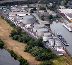
The ports of Schweinfurt extend within Schweinfurt for 3 km along the Main and include three landings , two lock outer ports , a port and a sports boat port . In popular parlance, almost the entire urban area south of the Main is simply referred to as the port , from which the official names for the two districts Hafen-West and Hafen-Ost were derived.
In terms of goods handling , the port of Schweinfurt lies ahead of the port of Nuremberg with 290,810 tons (2017) and 255,060 tons (2017) and also in front of the ports in the neighboring cities, the port of Bamberg and the port of Würzburg . The most important is the handling of mineral oil . The northern part of the port is completely an oil port; gases are also handled here, on the southern quay mainly bulk goods , and often fertilizer and grain in addition to coal.
geography
The ports of Schweinfurt are located at three spatially separate locations on the federal waterway south of Schweinfurt city center . You are at an altitude of 203 to 208 m above sea level. NN.
Importance of the port
After German reunification in 1990, new impulses were expected, as Thuringia has no ports, with the Schweinfurt harbor as the Thuringian Gate. However, these expectations were not fulfilled. After the opening of the continuous Main-Danube Canal in 1992, the volume of freight on the Main waterway fell sharply, completely unexpectedly, and with it the volumes handled in the port of Schweinfurt. Container handling is not possible in the port of Schweinfurt because of the unsuitable infrastructure such as cranes that are too small and the lack of space. Because the container ships became more and more important, but the freight capacities of these ships on the Main are too limited because of the limited clearance of the bridges and the lack of interest from industry. For this reason, the waterway has been deepened from 2.50 to 2.90 meters and widened from 36 to 40 meters for shipping since the end of the 2010s. In future, the ships can be loaded up to 400 tons and the push convoys up to 185 m long by up to 900 tons more than before.
In 2017, however, there was already another 8.8% increase in cargo handling in the Main area. The sharp decline in 2018, on the other hand, was solely due to the low water level as a result of the drought, especially on the main feeder Rhine . Therefore, 2018 are special values with no meaningfulness to the general development, which is why this article does not go into these values in more detail.
Size and equipment
| Location: Main km |
Port: | description | Quay length | Furnishing |
|---|---|---|---|---|
| 330.5 S (left) | port | Schweinfurt | 480 + 375 m | 2 cranes 16 t, pumps etc., siding |
| 332 N&S | Lands | Lock outer harbors | 4 × 250 m | |
| 332.9 N (right) | Lands | Passenger shipping | 163 m | Water, electricity, public transport |
| 333 S (left) | Lands | Transfer point Cramer-Mühle | 128 m | |
| 333.1 N (right) | Lands | Transhipment point at the customs house | 96 m | Public transport |
| 333.3 S (left) | Berths | Marina | only bars | on demand; up to 75 pleasure boats |
A tri-modal cargo handling ship / rail / road is possible in the harbor Schweinfurt.
The port area has a size of 28.42 ha including water areas. The water area is 4.14 ha, the track area 1.73 ha and the leased area 17.11 ha. The transhipment bank is 1.13 km and the track systems are 5.4 km long. 13 companies are located within the area belonging to the port.
South quay
Including the company's own systems, there are two double luffing cranes (load capacity in grab operation 6,000 kg, in hook operation 10,000 kg), a grain suction system and two grain loading systems, silo volumes for bulk goods (4,900 m³) and for grain (45,200 m³). The two largest companies on the Südkai are the joint power station Schweinfurt (GKS), which dominates the entire port due to its size, and the Schweinfurt malt factory , which belongs to the food manufacturer Ireks from Kulmbach .
North quay
The northern quay belongs entirely to the mineral oil company Erik Walther , which has its headquarters here. The quay is specially equipped for the handling and storage of liquids and gases. With two extinguishing systems for mineral oils, a tank farm for mineral oil (45,000 m³) and one for gas (1,054 m³). It also has a siding, but not on the quay, but north of the storage tanks. There are pumps there, but no cranes.
Walther has a network of filling stations and its own fleet of tankers . Over the Rhine-Main-route the ships delivering fuel from the German domestic refineries and from the ARA inland ports A ntwerpen , R otterdam and A msterdam into the high tank farm at the Schweinfurt harbor.
Lands
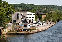
The upstream (east) lands are not developed with their own sidings and are not always equipped with industrial trucks. Only the passenger shipping area at the lower Marienbach has a stationary 8-ton crane that has not been in operation for a long time and is a memorial to the earlier sand handling.
additional
A pull-out track leads from the port to the Hafen-West industrial area . This industrial area and the neighboring Maintal industrial and commercial park complement the port facilities with important infrastructure. The Schweinfurt container terminal is located not far from the port, at Schweinfurt main station .
When planning the Maintal industrial and commercial park, a container port and a freight center (GVZ) were planned. The project was abandoned (see: Maintal, project container port ).
Schweinfurt is the location of the Schweinfurt Waterways and Shipping Office . Customs clearance is possible on site.
traffic
The port is equipped with a junction- free driveway to the federal motorway 70 (junction no. 6, Schweinfurt-Hafen ); Europastraße 48 runs on the BAB 70 . The access roads are dimensioned for a load capacity of up to 70 tons.
The areas are accessible via the state road 2272 and the BAB 70 (junction no. 8, Gochsheim ). For passenger shipping, there are direct connections to local public transport at Schweinfurt Stadt train station . Parking for private vehicles is very limited, but there are some bus stops.
history
Antiquity and the Middle Ages
The Main was already used as a waterway in Celtic times. There was graining and plowing , rafting , rowing and sailing. Attempts by the Romans to advance across the Maingraben to the east as far as the Elbe were repulsed by the Germanic Cimbri at the turn of the century . The Main continued to be an important trade route. In Carolingian times, there were first attempts to connect the waterway of the Main with the Danube region ( Fossa Carolina ), of which only contradicting records and a few findings on remains at Graben are available.
In the Middle Ages, large quantities of wood were rafted , for example to Frankfurt, the Ruhr area, but also for shipbuilding in Holland.
Modern times
The Bavarian original cadastre from 1808 already recorded two separate ports in Schweinfurt. The northwestern port, formerly used by civilians, was in the area of today's Anton-Niedermeier-Platz and has been completely filled in and built over. The southern port of protection was on the Main Island of Bleichrasen . This was heavily fortified, used mainly for military purposes and recently built over with the existing lock systems and their outer harbors. The area of today's Gutermann Promenade was also massively rounded off in terms of hydraulic engineering ; There were 17 water wheels there, which drove a number of mills, ball hammers and general blacksmith hammers on an industrial scale .
From 1830 on, Schweinfurt was then opened up from the west by steamship . The transport volume increased to up to 50 tons per vessel. The Ludwig-Danube-Main Canal was completed from 1836 to 1846 , and the quantities transported rose rapidly from 80,000 to 200,000 tons annually. Rail traffic became serious competition for shipping around 1880. From 1905, however, the transport volumes could be increased again through the introduction of chain shipping on the Main , in particular through coal deliveries from the Ruhr area.
Modern
In both the First and Second World Wars , shipping remained important for Schweinfurt as an industrial location and as a transshipment point for war goods. In 1943, the earlier systems were completely destroyed by the air raids on Schweinfurt and partially turned into a mud desert.
After the damage in World War II, the port facilities in Schweinfurt were completely redesigned. The expansion of the Main into a federal waterway in the last Main section from Schweinfurt to Bamberg began towards the end of the 1950s. a. with the construction of the Schweinfurt run- of -river power station , with barrage and lock. The Schweinfurt – Bamberg section was opened to traffic in 1962. Construction work on the port of Schweinfurt began in February 1961. The basin was flooded on May 20, 1962, and transshipment began a year later.
Web links
- Pictures of the construction and inauguration of the port in: mainpost.de: In the port of Schweinfurt, where the world arrives
- Video: Aerial photos 360: Schweinfurt harbor and surroundings from the air (2:10)
Individual evidence
- ↑ a b c Bavarian State Office for Statistics: Press release on the cargo handling of Bavarian inland navigation 2017, March 16, 2018. Accessed March 15, 2019 .
- ↑ Ports of Schweinfurt, location
- ↑ a b c d e mainpost.de: "The port that connects the Main with rail and road" , March 13, 2019. Accessed on March 14, 2019 .
- ↑ a b c d Stadtwerke Schweinfurt / Hafen / Technical data. Retrieved March 15, 2019 .
- ↑ Ports of Schweinfurt 1808 on the Bavaria Atlas Classic


