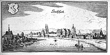
Hassfurt harbor
| Hassfurt harbor | |||
|---|---|---|---|
| Data | |||
| UN / LOCODE | DE HAS | ||
| owner | City of Hassfurt | ||
| operator | City of Hassfurt | ||
| opening | Antiquity | ||
| Port type | Protective harbor | ||
| Throughput | 10,000 t (2015) | ||
| website | http://www.hassfurt.de/ .. | ||
| Geographic information | |||
| place | Hassfurt | ||
| country | Bavaria | ||
| Country | Germany | ||
| Coordinates | 50 ° 1 '45 " N , 10 ° 30' 43" E | ||
|
|||
The port of Haßfurt is a port and industrial area of the city of Haßfurt in the Lower Franconian district of Haßberge .
geography
The port Haßfurt is located 500 meters southeast of the historic core and is a pure port and industrial area on the federal waterway Main . It is orographic right at Main kilometer 355.6 on the attitude Ottendorf at an altitude of 216 m above sea level. NN . Immediately to the south is the Haßfurt-Schweinfurt airfield, only one and a half kilometers away .
history
The Main was already used as a waterway in Celtic times. There was graining and plowing , rafting , rowing and sailing. Attempts by the Romans to advance across the Maingraben to the east as far as the Elbe were repulsed by the Germanic Cimbri at the turn of the century . The Main continued to be an important trade and transport route. In Carolingian times, the need to connect the waterway on the Main with that of the Danube area had long been recognized. The Fossa Carolina was built, only a few of the findings of the remains in the trench are preserved. In the Middle Ages, large quantities of wood were rafted , for example to Frankfurt, the Ruhr area, but also for shipbuilding in Holland.
A Merian steel engraving from 1656 shows the landfall on the Altmain and the busy shipping operations.
Between 1808 and 1817 the course of the river was straightened and the land near Haßfurt was tinted from the fairway . From 1830 onwards, steam shipping gradually replaced traditional shipping methods. Larger unloading depths enabled transport volumes of up to 50 tons per vessel. When the Ludwig-Danube-Main Canal was completed from 1836 to 1846 , the transport increased by leaps and bounds and the port was fortified in the Altmainarm as a protective port . Rail traffic became serious competition for shipping around 1850 when the Bamberg – Rottendorf railway went into operation. Around 1911, the volume of goods transported increased again through the expansion of chain shipping on the Main to Bamberg , in particular through coal deliveries from the Ruhr area.
At the beginning of the construction phase of the Main-Danube Canal around 1965, the port basin was modernized. It received a 100 m long quay wall and a turning facility for ships up to 90 m in length.
Since the dimensions of the dock for large motor cargo vessels from the draft was insufficient forth more of the envelope was closed down largely to the 1985th
Since then, the port of Haßfurt has mainly been used for leisure and passenger shipping.
Commerce and infrastructure
Of the total area of 21 hectares designated for the Haßfurt port area, 13 hectares have so far been used commercially. The port facilities themselves take up three hectares of this. Only sporadic forest and agricultural products, fodder and fertilizers, and building materials are handled.
In addition to BayWa , a number of transport, storage and logistics companies have settled in the port area. The area is paved for a quay length of 100 m and has a further 400 m banked banks. A possibility for rail loading is only 200 m away, if necessary on an open route. A direct development of the quay with a port railway was once considered. The planned route has been kept free, but the connection has never been made due to a lack of demand.
The pier is often used by passenger ships and passenger cabin ships, for example on river cruises .
The B 3 party ship also uses the landing stage and the Schweinfurt Waterways and Shipping Office maintains a small outskirts and a work boat there.
traffic
Municipal roads connect the port area with federal highway 26, which runs 350 m to the north, and this continues to connect to federal highway 70 .
Web links
Individual evidence
- ↑ Umschlagsätze, Hafen Marktbreit p. 129 ff. (.Pdf) ( Memento of the original of October 3, 2016 in the Internet Archive ) Info: The archive link was automatically inserted and not yet checked. Please check the original and archive link according to the instructions and then remove this notice.
- ^ Port of Hassfurt
- ^ Entry point Haßfurt on Frankentourismus.de
- ↑ WSA Schweinfurt, AB Haßfurt


