San Cristóbal District (Mariscal Nieto)
| San Cristóbal District | |
|---|---|
 Location of the district in the Mariscal Nieto province or in the Moquegua region |
|
| Basic data | |
| Country | Peru |
| region | Moquegua |
| province | Mariscal Nieto |
| Seat | Calacoa |
| surface | 542.7 km² |
| Residents | 1736 (2017) |
| density | 3.2 inhabitants per km² |
| founding | January 31, 1944 |
| ISO 3166-2 | PE MOQ |
| Website | www.municalacoa.gob.pe (Spanish) |
| politics | |
| Alcalde District | Ubaldo Salvador Cuayla Taco (2019-2022) |
| Political party | Frente de Integración Regional Moquegua Emprendedora FIRME |
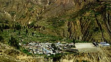
| View of Calacoa | |
Coordinates: 16 ° 44 ′ S , 70 ° 41 ′ W
The district of San Cristóbal is located in the Mariscal Nieto province of the Moquegua region in southwest Peru . The district founded on January 31, 1944 has an area of 542.73 km². At the 2017 census, there were 1736 inhabitants in the district. In 1993 the population was 2745, in 2007 it was 3518. The district administration is located in the 3458 m high town of Calacoa with 722 inhabitants (as of 2017). Calacoa is located about 55 km northeast of the provincial and regional capital Moquegua . In addition to Calacoa there are the larger towns of Muylaque (323 inhabitants), San Cristóbal (467 inhabitants) and Sijuaya.
Geographical location
The district of San Cristóbal is located in the Cordillera Volcánica in the northwest of the province of Mariscal Nieto. The Río Tambo runs south along the western district boundary.
The district of San Cristóbal borders in the west on the districts Quinistaquillas and Matalaque , in the north on the district Chojata (all three in the province of General Sánchez Cerro ), in the east, in the southeast and in the southwest on the district Carumas and in the central south on the district Cuchumbaya .
Web links
- Municipalidad Distrital de San Cristóbal - Calacoa
- Peru: Moquegua region (provinces and districts) at www.citypopulation.de
- INEI Perú

