Santa Ana District (La Convención)
| Santa Ana District | |
|---|---|
 The district of Santa Ana is located in the south of the province of La Convención (marked in red) |
|
| Basic data | |
| Country | Peru |
| region | Cusco |
| province | La Convención |
| Seat | Quillabamba |
| surface | 392 km² |
| Residents | 30,862 (2017) |
| density | 79 inhabitants per km² |
| founding | June 21, 1825 |
| ISO 3166-2 | PE-CUS |
| Website | www.laconvencion.gob.pe (Spanish) |
| politics | |
| Alcalde Provincial | Hernán De La Torre Dueñas (2019-2022) |
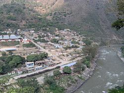
| Quillabamba on the Urubamba River | |
Coordinates: 12 ° 52 ′ S , 72 ° 42 ′ W
The Santa Ana district is located in the La Convención province of the Cusco region in south-central Peru . The district, founded in 1825, has an area of 392 km². At the 2017 census, there were 30,862 residents in the district. In 1993 the population was 32,703, in 2007 33,230. The administrative seat is the city of Quillabamba at an altitude of 3580 m with 26,288 inhabitants (as of 2017).
Geographical location
The district is located in the south of the province of La Convención, about 110 km northwest of the regional capital Cusco . The glaciated Cordillera Vilcabamba mountain range runs south of the district. The River Urubamba crosses the eastern part of the district in a northerly direction. The longitudinal extension in SW-NE direction is 33 km, the maximum width about 18 km. The lowest point in the district is around 950 m , the highest at over 4000 m .
Web links
- Peru: Region Cusco (provinces and districts) at www.citypopulation.de
- INEI Perú
