Soraya district
| Soraya district | |
|---|---|
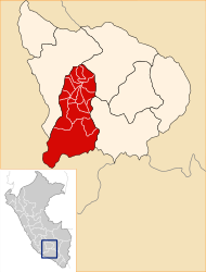
 The Soraya District is centrally located in the Aymaraes Province (marked in red) |
|
| Basic data | |
| Country | Peru |
| region | Apurímac |
| province | Aymaraes |
| Seat | Soraya |
| surface | 44.4 km² |
| Residents | 745 (2017) |
| density | 17 inhabitants per km² |
| founding | January 2, 1857 |
| ISO 3166-2 | PE-APU |
| politics | |
| Alcalde District | Tito Beltran Vargas Segovia (2019-2022) |
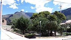
| Plaza de Armas in Soraya | |
Coordinates: 14 ° 9 ′ 53 " S , 73 ° 18 ′ 54" W
The Soraya district is located in the Aymaraes province in the Apurímac region in the central south of Peru . The district was founded on January 2, 1857. It has an area of 44.4 km². The 2017 census counted 745 inhabitants. In 1993 the population was 802, in 2007 it was 771. The district administration is located in the 2870 m high village of Soraya with 174 inhabitants (as of 2017). Soraya is 16 km north-northwest of the provincial capital Chalhuanca .
Geographical location
The Soraya district is located in the Andean highlands on the east bank of the Río Chalhuanca in the center of the Aymaraes province.
The Soraya district is bordered to the west by the districts Sañayca and Capaya , on the north by the district Ihuayllo , on the east by the district Justo Apu Sahuaraura and the south by the district Chalhuanca .
Web links
- Peru: Region Apurímac (provinces and districts) at www.citypopulation.de
- INEI Perú

