Chalhuanca district
| Chalhuanca district | |||
|---|---|---|---|
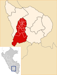
 The Chalhuanca district is centrally located in the Aymaraes province (marked in red) |
|||
| Symbols | |||
|
|||
| Basic data | |||
| Country | Peru | ||
| region | Apurímac | ||
| province | Aymaraes | ||
| Seat | Chalhuanca | ||
| surface | 322.3 km² | ||
| Residents | 4928 (2017) | ||
| density | 15 inhabitants per km² | ||
| ISO 3166-2 | PE-APU | ||
| Website | www.muniaymaraes.gob.pe (Spanish) | ||
| politics | |||
| Alcalde Provincial | José Alberto Argote Cárdenas (2019-2022) |
||
| Chuquinga, a suburb of Chalhuanca | |||
Coordinates: 14 ° 18 ′ S , 73 ° 15 ′ W
The Chalhuanca district is located in the Aymaraes province of the Apurímac region in south- central Peru . The district has an area of 322.34 km². At the 2017 census, 4,928 people lived in the district. In 1993 the population was 4458, in 2007 4558. The district administration is located in the provincial capital Chalhuanca , located on the Río Chalhuanca at an altitude of 2888 m .
Geographical location
The Chalhuanca district is centrally located in the Aymaraes province. The city of Chalhuanca is located about 85 km southwest of the regional capital Abancay . The Chalhuanca district extends over the Andean highlands . The Río Chalhuanca flows through the district in a west-northwest direction.
The Chalhuanca district borders in the west on the district Sañayca , in the north on the districts Soraya and Tapairihua , in the east on the districts Yanaca , Pocohuanca and Sabaino ( province Antabamba ) and in the south on the districts Caraybamba and Cotaruse .
Localities
- Anccoccayo
- Chaccarahua
- Jayo
- Mutca
- Pauccaraya
- Pincahuacho
- Unchiña
Web links
- Municipalidad Provincial de Aymaraes
- Peru: Region Apurímac (provinces and districts) at www.citypopulation.de


