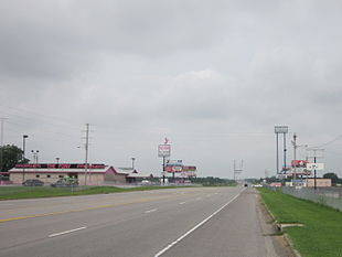
East Cape Girardeau
| East Cape Girardeau | ||
|---|---|---|
 East Cape Girardeau |
||
| Location in Illinois | ||
|
|
||
| Basic data | ||
| State : | United States | |
| State : | Illinois | |
| County : | Alexander County | |
| Coordinates : | 37 ° 18 ′ N , 89 ° 30 ′ W | |
| Time zone : | Central ( UTC − 6 / −5 ) | |
| Residents : | 437 (status: 2000) | |
| Population density : | 87.4 inhabitants per km 2 | |
| Area : | 5.0 km 2 (approx. 2 mi 2 ) of which 5.0 km 2 (approx. 2 mi 2 ) is land |
|
| Height : | 102 m | |
| Postcodes : | 62957 | |
| Area code : | +1 618 | |
| FIPS : | 17-21605 | |
| GNIS ID : | 1669473 | |
| Mayor : | Joe Aden | |
East Cape Girardeau is a village in Alexander County in southern US -amerikanischen State of Illinois on the Mississippi River . In 2000 East Cape Girardeau had 437 residents.
history
East Cape Girardeau was incorporated in 1975.
geography
The city extends over an area of 5.0 km², which consists exclusively of land.
East Cape Girardeau is on the east bank of the Mississippi River, which forms the border with Missouri . The much larger city of Cape Girardeau is located there on the west bank of the river . Both cities are connected by the Bill Emerson Memorial Bridge .
Illinois State Route 146 leads through East Cape Girardeau, which connects Illinois State Route 3 , which runs further east, with the bridge to Missouri.
East Cape Girardeau is 53.5 km northwest of Fort Defiance near Cairo , where the Ohio River flows into the Mississippi River at the interface of the states of Illinois, Missouri and Kentucky .
St. Louis is 190 km in a north-northeast direction, Illinois' capital Springfield 318 km in the north, Indiana's capital Indianapolis 491 km in the northeast, Kentucky's largest city Louisville is 406 km in an east-northeast direction, Tennessee's capital Nashville 327 km in the southeast, Memphis , Tennessee 173 miles to the south-southwest and Missouri's capital, Jefferson City, 333 miles to the northwest.
Demographic data
In the 2000 census, the population was 437. These were distributed over 196 households in 130 families. The population density was 85.6 / km². There were 235 buildings, which corresponds to a building density of 46.1 / km².
The population in 2000 was 97.25% white , 0.69% African American , 0.23% Asian, and 1.14% other. 0.69% said they came from at least two of these groups. 2.29% of the population were Hispanics from any of the above groups.
22.7% were under 18 years of age, 8.2% between 18 and 24, 27.9% between 25 and 44, 25.6% between 45 and 64 and 15.6% 65 and older. The average age was 39 years. For every 100 women there were statistically 95.1 men, 94.3 among the over 18 year olds.
The median income per household was $ 29,688 and the median family income was $ 33,897. The average income for men was $ 31,932 and that for women was $ 16,875. The per capita income was $ 14,420. Around 10.9% of families and 10.5% of the total population had their income below the poverty line .
Individual evidence
- ↑ US Postal Service - ZIP Codes
- ↑ Evidence for distance information: Google Maps
- ↑ US Census Bureau - East Cape Girardeau, Illinois
