Eilhard Lubin
Eilhard Lubin , actually Eilhard Lübben or Eilert Lübben , also Lubinus (born March 24, 1565 in Westerstede , † June 2, 1621 in Rostock ) was one of the most famous scholars of his time as a theologian, philosopher and mathematician. Through the Lubin map , his most important and extensive work, he is known today as an important geographer of the 17th century.
Life
Eilhard Lubin was a son of the Westersted pastor Friedrich Lübben. With the support of Count Johann VII. Von Oldenburg , from whom he received a scholarship, he studied from 1588 to 1591 at the universities of Leipzig , Cologne , Helmstädt , Strasbourg , Jena , Marburg and Rostock . He graduated from the University of Rostock in 1591, where he became a lecturer in 1595 and professor of poetry in 1596. In 1605 he received his doctorate and became professor of theology as the successor to the late Johannes Freder. He was rector of Rostock University four times, the last time he died in 1621.
Eilhard Lubin was married to Katharina Lauremberg from 1604 and had the daughter Katharina Lubinus (1615–1638) with her.
plant
Lubin justified his reputation with philological writings: The "Antiquarius" was a compilation of obsolete Latin words. "Clavis Graecae linguae", a dictionary of the Greek language, reached eleven editions. His editions of Horace and Anacreon also achieved high esteem. His theological work "Phosphorus" made him suspect of cryptocalvinism , so that in 1607 he felt compelled to revoke the principles contained therein.
Today he is best known as a cartographer. So he made a map of the Lübeck area for Lübeck . His first cartographic work was the map of the island of Rügen, which appeared as a copper engraving by Jodocus Hondius in 1609 in the atlas of Mercator and Hondius "L'Atlas ou Mediationes cosmographiques". Lubinus dedicated it to his patron, Duke Philipp Julius of Pommern-Wolgast.
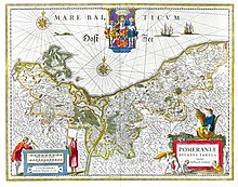
The card was also recognized by Duke Philip II of Pomerania-Stettin. In 1610 he commissioned Lubinus to draw up a map of the entire Duchy of Pomerania, which is still known today as the Lubin map . After extensive preparatory work, Lubinus traveled through Pomerania from August to October 1612 and carried out the survey of the country. In 1614 it was decided to add views of the cities, the coats of arms of the noble families and portraits of the dukes living at the time to the map, which increased the workload considerably. Finally, there was also a family tree of the Greifenhaus and a geographical description of the duchy. The engraver Nikolaus Geelkercken (Geilenkerken) engraved the map in Amsterdam on 12 copper plates. The printed sheets were assembled to form a card measuring 1.25 x 2.21 meters. In November 1618, a few months after the death of Philip II, Lubinus was able to present the first copies to Philipp Julius in Wolgast. For a long time, the Lubin map formed the basis of the printed Pomeranian maps and was also often reworked into an atlas map.
Fonts
- Phosphorvs, sive de prima cavsa et natvra mali tractatus hypermetaphysicus, in quo multorum gravißimae et dubitationes tolluntur, et errores deteguntur. Augustin Ferber the Elder Ä., Rostock 1596.
literature
- August Mutzenbecher : Lubinus, Eilhardus . In: Allgemeine Deutsche Biographie (ADB). Volume 19, Duncker & Humblot, Leipzig 1884, p. 331.
- Karl Ernst Hermann Krause : additions and corrections. Volume XIX . In: Allgemeine Deutsche Biographie (ADB). Volume 20, Duncker & Humblot, Leipzig 1884, p. 747.
- Gottfried von Bülow : additions and corrections. Volume XIX . In: Allgemeine Deutsche Biographie (ADB). Volume 21, Duncker & Humblot, Leipzig 1885, p. 796.
- Wilhelm Schmidt-Biggemann : Lubinus, Eilhard. In: New German Biography (NDB). Volume 15, Duncker & Humblot, Berlin 1987, ISBN 3-428-00196-6 , p. 263 f. ( Digitized version ).
- Eckhard Jäger, Roderich Schmidt (ed.): The large Lubinsche map of Pomerania from 1618. With descriptive text by Alfred Haas (1926). Nordostdeutsches Kulturwerk, Lüneburg 1980, ISBN 3-922296-18-1 .
Web links
- Literature by and about Eilhard Lubin in the catalog of the German National Library
- Works by and about Eilhard Lubin in the German Digital Library
- Publications by and about Eilhard Lubin in VD 17 .
- Literature about Eilhard Lubin in the state bibliography MV
- Entry on Eilhard Lubin in the Catalogus Professorum Rostochiensium
- Lubin, Eilhard. In: Barth Lexicon. City of Barth, accessed January 3, 2015 .
- Philip II, Eilhard Lubinius and the large map of the Duchy of Pomerania
- The Lubinsche Karte on the page of the "Historical Society Zinnowitz" to the Museum Zinnowitz
Individual evidence
- ↑ Promotion to the Master's degree from Eilhard Lubinus in the Rostock matriculation portal
- ^ Reception by Eilhard Lubinus in the Rostock matriculation portal
- ↑ Doctorate from Eilhard Lubinus in the Rostock matriculation portal
- ↑ Entry on Lübben, Eilhard at the Mecklenburg-Western Pomerania State Library
- ↑ DNB 12870229X
| personal data | |
|---|---|
| SURNAME | Lubin, Eilhard |
| ALTERNATIVE NAMES | Lubinus, Eilhard; Lubinus, Eilhardus; Lübben, Eilhard; Luebben, Eilert |
| BRIEF DESCRIPTION | German theologian, mathematician, geographer |
| DATE OF BIRTH | March 24, 1565 |
| PLACE OF BIRTH | Westerstede |
| DATE OF DEATH | June 2, 1621 |
| Place of death | Rostock |


