
Ermionida
|
Municipality of Ermionida Δήμος Ερμιονίδας |
|||
|---|---|---|---|
|
|||
| Basic data | |||
| State : |
|
||
| Region : | Peloponnese | ||
| Regional District : | Argolis | ||
| Geographic coordinates : | 37 ° 26 ' N , 23 ° 13' E | ||
| Area : | 417.59 km² | ||
| Residents : | 13,551 (2011) | ||
| Population density : | 32.5 inhabitants / km² | ||
| Seat: | Kranidi | ||
| LAU-1 code no .: | |||
| Districts : | 2 parishes | ||
| Local self-government : |
3 city districts 5 local communities |
||
| Location in the Peloponnese region | |||
 |
|||

The Greek municipality of Ermionida ( pronunciation : [ ɛrmjɔˈniða ], Greek Ερμιονίδα ( f. Sg. ), Katharevousa Ερμιονίς Ermionis ) was formed on January 1, 2011 from the merger of the previously existing municipalities Ermioni and Kranidi . Its area corresponds to the province of Ermioni-Kranidi, which existed until 1997 , the eight municipalities of which were merged into two municipalities with the implementation of the Kapodistrias program in 1999. The name is derived from ancient Greek Ἑρμιονίς Hermionis , which means the area around the ancient city of Hermionē.

geography
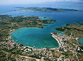
Ermionida covers the southern part of the Argolic Peninsula. To the northwest, Mount Didymo separates its territory from that of the municipality of Nafplio; a mountain ridge rising to just over 600 meters extends to the southeastern tip of the peninsula and separates Erminoida from the municipality of Trizinia-Methana , which belongs to the Attica region. Two small sections of the municipality border connect Ermionida east with the municipality of Poros . The south of the municipal area is occupied by the Kranidi peninsula, whose strongly indented coast is one of the tourist destinations of the Peloponnese of Greece. The larger islands of Spetses , Dokos and Hydra , located south of the municipality , also belong to Attica.

Ermioni
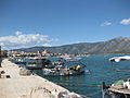
Kilada
Porto Heli


Community structure
The communities that existed until 1997 have had the status of urban districts since 2011 (singular Greek δημοτική κοινότητα dimotiki kinotita ) or local communities ( τοπική κοινότητα topiki kinotita ) and elect their own local representatives. The population figures come from the results of the 2011 census.
- Ermioni Municipality - Δημοτική Ενότητα Ερμιόνης - 4.099
- Ermioni District - Δημοτική Κοινότητα Ερμιόνης - 3,062
- Agii Anargyri - Άγιοι Ανάργυροι - 193
- Achladitsa - Αχλαδίτσα - 135
- Ermioni - Ερμιόνη - 2.505
- Kouverta - Κουβέρτα - 81
- Petrothalassa Ermionis - Πετροθάλασσα Ερμιόνης - 148
- Local community Iliokastro - Τοπική Κοινότητα Ηλιοκάστρου - 558
- Iliokastro - Ηλιόκαστρο - 550
- Triandafylli - Τριανταφύλλι - 8
- Local community Thermisia - Τοπική Κοινότητα Θερμησίας - 479
- Agia Ekaterini - Αγία Αικατερίνη - 15
- Akti Ydras - Ακτή Ύδρας - 7
- Metochi - Μετόχι - 36
- Pigadia - Πηγάδια - 52
- Plepi - Πλέπι - 18
- Solinari - Σωληνάρι - 20
- Thermisia - Θερμησία - 331
- Ermioni District - Δημοτική Κοινότητα Ερμιόνης - 3,062
- Kranidi Municipality - Δημοτική Ενότητα Κρανιδίου - 9,452
- Kranidi district - Δημοτική Κοινότητα Κρανιδίου - 4,441
- Agios Nikolaos - Άγιος Νικόλαος - 8
- Avlona - Αυλώνα - 80
- Discouria - Δισκούρια - 26
- Doryfi - Δορούφι - 2
- Kambos - Κάμπος - 41
- Kounoupi - Κουνούπι - 87
- Kranidi - Κρανίδι - 4,006
- Lakkes - Λάκκες - 14
- Petrothalassa (Flamboura) - Πετροθάλασσα (Φλάμπουρα) - 177
- Thyni - Θυνί - uninhabited
- District Porto Heli (Portocheli) - Δημοτική Κοινότητα Πορτοχελίου - 2133
- Agios Emilianos - Άγιος Αιμιλιανός - 42
- Chinitsa - Χινίτσα - 71
- Chinitsa (island) - Χηνίτσα - 2
- Kosta - Κόστα - 71
- Porto Heli (Portocheli) - Πορτοχέλιον - 1.817
- Ververouda - Βερβερούδα - 130
-
Local community Didyma - Τοπική Κοινότητα Διδύμων - 1.320
- Agioa Ioannis - Άγιος Ιωάννης - 10
- Didyma - Δίδυμα - 1.047
- Loukaiti - Λουκαΐτι - 196
- Pelei - Πελεή - 9
- Rado - Ράδο - 57
- Salandi - Σαλάντι - 1
- Local community Kilada - Τοπική Κοινότητα Κοιλάδος - 1.249
- Doroufi - Δορούφι - 28
- Kambos - Κάμπος - 56
- Kilada - Κοιλάδα - 1.165
- Coronida - Κορωνίδα - uninhabited island
- Local community Fourni - Τοπική Κοινότητα Φούρνων - 309
- Fourni - Φούρνοι - 301
- Paralia Fournon - Παραλία Φούρνων - 8
- Kranidi district - Δημοτική Κοινότητα Κρανιδίου - 4,441

traffic
Porto Cheli Airport
Porto Cheli Airport ( IATA : PKH , ICAO : LGHL ) is a private airfield near Porto Cheli and has not been in operation since 2008. The paved runway has a length of 678 meters. The airfield is at an altitude of 21 m (70 ft) above sea level .
![]()
Individual evidence
- ↑ a b Results of the 2011 census at the National Statistical Service of Greece (ΕΛ.ΣΤΑΤ) ( Memento from June 27, 2015 in the Internet Archive ) (Excel document, 2.6 MB)