Estorf (village)
|
Estorf
Esdorp Estorf municipality
|
||
|---|---|---|
| Coordinates: 53 ° 34 ′ 42 ″ N , 9 ° 12 ′ 19 ″ E | ||
| Residents : | 610 (Jan 1, 2012) | |
| Incorporation : | July 1, 1972 | |
| Postal code : | 21727 | |
| Area code : | 04140 | |
|
Location of Estorf in Lower Saxony |
||
|
Aerial view
|
||
Estorf ( Low German Esdbod ) is the eponymous district of the municipality of Estorf in the Lower Saxony district of Stade . The smaller settlement of Bötz also belongs to Estorf .
geography
Estorf is located in the west of the Stade district between Kranenburg and Brobergen in the north and Behrste and Elm in the south. Oldendorf lies to the east and Graepel and Schönau an der Oste to the west.
The water from the Estorf district flows over the Graepler Mühlenbach and Wiemelken into the Oste.
The location Bötz belongs to Estorf and is located on the old church path from Elm to Oldendorf. In the north-east and south-west the route touches the L 114. A side road connects Estorf am Osterberg with the Bötz .
history
Estorf was first mentioned in 1111 as Esgkethorp .
Administrative history
Before 1885 Estorf belonged to Börde Oldendorf in the office of Himmelpforten , after 1885 to the district of Stade and since 1932 to the current district of Stade .
Incorporation
On July 1, 1972 were part of the government reform the communities Estorf, Gräpel and Behrste the new municipality Estorf merged.
Population development
| year | Residents |
|---|---|
| 1824 | 46 fire places |
| 1848 | 367 people, 72 houses |
| 1871 | 517 people, 81 houses |
| 1910 | 526 |
| 1925 | 509 |
| 1933 | 525 |
| 1939 | 499 |
| 1961 | 671 |
| 1970 | 589 |
| 2012 | 610 |
religion
Estorf is evangelical-Lutheran and belongs to the parish of the Martinskirche in Oldendorf .
For the (few) Catholics as St. Michael Church in Bremervörde responsible, since 1 September 2010 on the parish of the Holy Spirit in Stade belongs.
politics
coat of arms
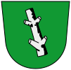
Blazon : The coat of arms of Estorf shows a silver tree trunk on a green background with two stumps on each side. Meaning : The coat of arms was taken from the coat of arms of the former Lords of Estorf
Culture
societies
- Volunteer firefighter
- MTV Estorf (founded 1926)
- Rifle Club Estorf (founded 1936)
Economy and Infrastructure
traffic
State road 114, which leads to federal road 73 to Himmelpforten , runs through the village . There is a connection to Stade and Hamburg via the federal highways 73 . At Elm , the state road 114 connects to the federal road 74 , which leads to Bremervörde . Smaller back roads lead to Brobergen and Gräpel .
The next rail connection is in Himmelpforten, 10 km away, to the Niederelbebahn ( Cuxhaven - Hamburg).
education
There is a primary school in Estorf . Secondary schools are located in Oldendorf ( secondary school with grammar school branch ), Stade ( Vincent-Lübeck-Gymnasium ) and Bremervörde ( grammar school Bremervörde ).
Companies
In the street Wietstruk had Volksbank Fred Beck-Oldendorf a branch which in 2016 concluded.
Supply and disposal
The wastewater has been treated in the Gräpel sewage treatment plant since 1991.
literature
- Friedrich Holst: Grupilinga and the daughters, the history of the Estorf community. 1981
Individual evidence
- ↑ CHCF Jansen: Statistical Handbook of the Kingdom of Hanover . In Commission of the Helwings̓chen Hofbuchhandlung, 1824 ( google.de [accessed on September 30, 2019]).
- ↑ Friedrich W. Harseim, C. Schlüter: Statistical Manual for the Kingdom of Hanover . Schlueter, 1848 ( google.de [accessed September 30, 2019]).
- ↑ Prussia (Germany) Royal Statistical Bureau: The communities and manor districts of the Prussian state and their population: Based on the original materials of the general census of December 1, 1871 . Publishing house of the Royal Statistical Bureau, 1873 ( google.de [accessed on September 30, 2019]).
- ↑ Welcome to Gemeindeververzeichnis.de. Retrieved September 30, 2019 .
- ↑ a b c Sitemap | Redaktionstest.net. Retrieved September 30, 2019 (German).
- ↑ 1961 census .
- ↑ 1970 census .


