
ʻEua
| ʻEua | ||
|---|---|---|
 |
||
| Waters | Pacific Ocean | |
| Archipelago | Tongatapu Group ( Tonga Islands ) | |
| Geographical location | 21 ° 23 ′ S , 174 ° 56 ′ W | |
|
||
| length | 19 km | |
| width | 7.5 km | |
| surface | 86.7 km² | |
| Highest elevation | Te'emoa 312 m |
|
| Residents | 4950 (2016) 57 inhabitants / km² |
|
| main place | ʻOhonua | |
 |
||

ʻEua belongs to the Tongatapu archipelago in the Kingdom of Tonga . It is about 40 km southeast of the main island of Tongatapu and is one of the oldest islands in the Pacific .
geography
ʻEua is 19 km long, 7.5 km wide, has an area of 86.7 km² and has 4950 inhabitants (as of 2016) in 15 villages.
The island can be reached by plane and ship from Nukuʻalofa . The journey time by ship is around three hours. The largest city and division capital is ʻOhonua (1626 inhabitants including Taʻanga). All the island's facilities are located there, including the port of Nafanua, two supermarkets, a post office, a bank and a gas station. The island has four accommodations. The one in Tufu is suitable for whale watching .
The island is very hilly and partly covered by a dense tropical rainforest . The highest point of the island is the Te'emoa with 312 m above sea level. A notable attraction on the island is one of the largest and oldest weeping figs in the world.
Annual rainfall is 2700 mm, with 2/3 falling during the rainy season from November to April.
administration
The 'EUa' division also includes the 35 hectare sub-island Kalau , which is 3.8 km southwest of the southern tip of 'EUa ( Lakufa'anga ).
The ʻEua division is divided into two districts:
- ʻEua Motuʻa ( ʻEua Proper) in the north, with 2949 inhabitants in six villages
- ʻEua Niuafoʻou (ʻEua Foʻou) in the south, with 2257 inhabitants in nine villages
The nine villages of the southern district ʻEua Niuafoʻou (or ʻEua Foʻou for short) are all named after the villages on the island of Niuafoʻou , and were founded by former residents of Niuafoʻou who had to leave this island in 1946 because of a volcanic eruption.
The northern district, in contrast, is called ʻEua Proper , i. H. actually called ʻEua . To him belongs the enclave but also the village Kolomaile further south, that of the former inhabitants of the island 'Ata was founded and named after'Atas historic main town.
history
'Eua's “discoverer” was the Dutch navigator Abel Tasman on January 21, 1643 , but he did not set foot on the island. He named it "Middelburg Island" after the capital of the Dutch province of Zeeland .
James Cook landed on Middleburg Island on October 2, 1773, was warmly received, shown around, but could not replenish his supplies as desired. That is why he drove on the same day to "Amsterdam Island", today Tongatapu .
ʻEua became home to the last 200 inhabitants who remained on ʻAta from the mid-1860s , after 144 men had been abducted by Peruvian slave traders in June 1863 and sold as foreign workers for guano mining on the Chincha Islands .
After the events of King George Tupou I became known, the remaining residents were brought to safety on three schooners from ʻAta to ʻEua.
Descendants of the evacuated residents of ʻAta still live in the village of Haʻatuʻa in the west of 'Eua. A settlement was established there that bears the name of the former 'Ata village of Kolomaile. Kolomaile had a population of 511 (including Haʻatuʻa) at the 2006 census.
gallery

View of the main town ʻOhonua, with whales in the foreground
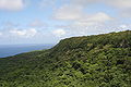
Much of the east side of Eua is part of the Eua National Park . Photo facing south from a platform on the edge of the park.

Rainforest on ʻEua


literature
- J. Edward Hoffmeister: Geology of Eua, Tonga, Honolulu 1932 (= Bernice P. Bishop Museum Bulletin No. 96)
Web links
Individual evidence
- ↑ UNEP
- ^ Tonga Tonga National Population and Housing Census 2016. Statistics Department Tonga, 2016, accessed April 9, 2018 .
- ↑ Kingdom of Tonga, Statistics Department: Results for Tonga Population Census 2006 ( Memento from August 24, 2010 in the Internet Archive ) (PDF; 161 kB)
- ↑ The Official Website of the Tongan Government: Divisions - 'Eua ( Memento of August 24, 2010 in the Internet Archive )
- ↑ Logbooks of the journeys of James Cook
Niua Group : Niuafoʻou | Niuatoputapu | Tafahi
Vavaʻu group : Fonualei | Late | Toku | Vava'u
Ha'apai group : Fatumanongi | Foa | Fotuhaʻa | Ha'ano | Hakauata | Kao | Lifuka | Limu | Lofanga | Luahoko | Luangahu | Meama | Niniva | Nomuka | Nukupule | Ofolanga | Tofua | 'Uiha | Uoleva | Uonukuhahake
Tongatapu Group: ʻAta | ʻEua | Tongatapu
Disputed Area: Minerva Reefs