
Erbach (Blies)
| Erbach | ||
 The Erbach flows into the Blies between Schwarzenbach and Wörschweiler in the Mastau |
||
| Data | ||
| Water code | DE : 26424 | |
| location | Germany | |
| River system | Rhine | |
| Drain over | Blies → Saar → Moselle → Rhine → North Sea | |
| source | Between Altbreitenfelderhof and Höchen | |
| muzzle | At Schwarzenbach in the Blies coordinates: 49 ° 17 '18 " N , 7 ° 18' 43" E 49 ° 17 '18 " N , 7 ° 18' 43" E |
|
| Mouth height |
222 m above sea level NN
|
|
| length | 16.1 km | |
| Catchment area | 33 km² | |
| Drain |
MQ |
322 l / s |
| Left tributaries | Ebersbach, Hähnchensborn, Herrgottshübelbach, Reichersbach | |
| Right tributaries | Zwerchalmbach, Taubentalbach, Schlosswiesgraben, Felsbach, Schmalaugraben, Erbacher Schmalaubach | |
| Flowing lakes | Möhlwoog , Brückweiher , Schloßweiher | |
| Medium-sized cities | Homburg | |
| Residents in the catchment area | approx. 45,000 | |
The Erbach is a sixteen kilometer long stream in the eastern Saarland , which, coming from the north-northeast, flows into the Blies from the left .
origin of the name
The Erbach district of the city of Homburg is named after the brook. The place name Erbach occurs more frequently in Germany. The origin of the name is not the same, however, but is derived from the boar or from the alder or from a stream with stronger earth entrainment. The first derivation has been proven for the Erbach, so it is a creek where “the boar was noticed”. The left tributary Ebersbach already provides an indication of this name interpretation. In a document from 1346 the places "Vogelbach" , "Eberbach" and "Homburg" are mentioned together, so that the spelling "Eberbach" for "Erbach" is historically documented.
geography
course
The Erbach rises in the Naßwald between Altbreitenfelderhof and Höchen and crosses the urban area of Homburg for a good 16 km in a south-westerly direction. It flows into the Blies in the Mastau near Schwarzenbach .
Tributaries
The stream has three left and five right tributaries in its course.
- The Ebersbach rises at the Neubreitenfelderhof and flows into the Erbach from the left in Jägersburg in the Hammelstal.
- Opposite it flows the Taubentalbach , which rises in the upper Taubental. However, it only reaches the Erbach in strong water, as a biotope has been created at the mouth in which most of the incoming water seeps away or evaporates.
- The Eisenkautbach rises below the youth camp site Am Herrgottshübel and flows out from the left shortly before the castle pond.
- The Felsbach rises in the Naßwald near the Websweilerhof , runs through the nature reserve at the Pottaschbrunnen and flows into the Brückweiher from the right.
- The Schmalaugraben rises from the take-away car park at the motorway entrance before Kleinottweiler , crosses under the A 6 and flows into the Erbach from the right in the Schmalau.
- The Erbacher Schmalaubach rises from the take-away car park in front of Reiskirchen, runs below Magdeburger Straße along the Berlin residential complex and flows into the Erbach from the right on Schmalauweg.
- The Reichersbach rises at the dog sports field in Sanddorf and flows into the Erbach from the left in the Closenbruch.
Pond
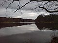
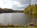
During its course, it flows through several smaller ponds and three large lakes: the Schlossweiher (1.7 hectares ), the Brückweiher (7.1 hectares) and the largest of these lakes with an area of 7.4 hectares, the Möhlwoog and the Closenbruch nature reserve at Bruchhof .
Hydrology
A level measuring system from LUA Saarland has been installed and active since December 16, 2013. It is located 1.63 km above the mouth in the Homburg district of Beeden . The mean discharge value (MQ) is 0.172 m³ / s. Added to this are 0.150 m³ / s from treated sewage from the EVS - Homburg, so that the Erbach at its mouth has an average of 0.32 m³ of water.
Renaturation
The Erbach used to serve as a sewer for Homburg and the districts of Jägersburg, Websweiler , Altbreitenfelderhof , Erbach, Reiskirchen , Bruchhof, Sanddorf and parts of the Bexbach district of Höchen and was therefore expanded with concrete half-shells. For some time now it has been free of wastewater thanks to the construction of a parallel collector. The stream should be completely renatured by the end of 2012. In fact, the renaturation only began in January 2017. For the planned B 423 bypass Schwarzenbach / Schwarzenacker , the Erbach and Ebersbach will be renatured in two construction phases over a length of 6 kilometers. The concrete shells in the Erbach have already been removed between Schmalauweg and Berliner Straße. The renaturation of the Ebersbach has already been completed. The stream between Möhlwoog and the motorway in the area of the Reiskircher mill is currently being renatured.
Picture gallery of the lakes flowed through

The castle pond at Gustavsburg in Jägersburg
The bridge pond in Jägersburg.
The Möhlwoog in the ice cellar between Jägersburg and Reiskirchen is the largest lake on the Erbach

.JPG)

Individual evidence
- ↑ Topographic map 1: 25,000
- ↑ WFD Saarland surface water bodies - target achievement (PDF; 58 kB)
-
^ Karl Fischer: Interpretation of the city name and the individual city districts. In: Blätter zur Geschichte der Stadt Homburg , Born 1958, page 6
Available online at the Archives of the City of Homburg: Text version ( page no longer available , search in web archives ) Info: The link was automatically marked as defective. Please check the link according to the instructions and then remove this notice. and facsimile ( page no longer available , search in web archives ) Info: The link was automatically marked as defective. Please check the link according to the instructions and then remove this notice. . - ↑ Renaturation for the Erbach - Ebersbach will be designed in a natural way / First work has started
- ↑ The Erbach loses its concrete corset