
Long-distance hiking trail Harz - Eichsfeld - Thuringian Forest
| Long-distance hiking trail Harz - Eichsfeld - Thuringian Forest | |
|---|---|
 Start of the hiking trail on the Bode in Thale |
|
| Data | |
| length | 188 km |
| location | Germany |
| Markers |

|
| Starting point |
Thale , Saxony-Anhalt , Germany 51 ° 44 ′ 40.1 ″ N , 11 ° 1 ′ 33 ″ E |
| Target point |
Hörschel , Thuringia , Germany 51 ° 0 ′ 24.5 ″ N , 10 ° 13 ′ 41.1 ″ E |
| Type | Long-distance hiking trail |
| The highest point | 800 |
| Lowest point | 200 |
| Level of difficulty | medium |
The long-distance hiking trail Harz - Eichsfeld - Thuringian Forest (also Harz-Eichsfeld-Thuringian Forest way ; abbreviated: HET ) is a long-distance hiking trail that leads through Saxony-Anhalt , Lower Saxony and Thuringia .
Details
The official length of the hiking trail is 188 kilometers, the actual length was determined to be 202 kilometers. The trail is marked with a blue triangle on a white mirror.
The hiking trail begins in Thale ( Harz district ) and runs from there along the Bode in a westward direction to the Wendefurth dam . From there the path continues over the Rappbodetalsperre along Bode to the union of Warmer and Kalter Bode below Königshütte. Further in the valley of the Kalten Bode the path leads into the Harz National Park . The localities Elend and Schierke are crossed through and then the border with Lower Saxony at the triangular post. There the path leads through the forests of the national park via Oderbrück and past the Oderteich pond in a south-westerly direction out of the national park to St. Andreasberg . From there it goes on to the southwest to the Oder and a short distance along it to Bad Lauterberg . The path then reaches Thuringia and the Eichsfeld . Here it goes over a more open landscape and some villages, past, among other things, the former Bischofferode potash plant , Worbis and in Lengenfeld unterm Stein under the Lengenfeld viaduct . The path also leads up to Gleichenstein Castle on the 459.7 m high Schloßberg. Further south, the path reaches the Wartburg district . Here the route runs past Normannstein Castle and then between Treffurt , Falken and Frankenroda, mostly along the Werra and on the route of the Werra Valley Cycle Path . South of Creuzburg , the long-distance trail leads through the nature reserve and Stiftsgut Wilhelmsglücksbrunn as well as the place Spichra along the Werra and finally ends at the church in the Eisenach district of Hörschel , where it meets the Rennsteig and thus reaches the Thuringian Forest .
Stages
The entire route is divided into eight sections:
- Thale - Wendefurth : 18.0 kilometers
- Wendefurth - Schierke : 28.2 kilometers
- Schierke - St. Andreasberg : 21.0 kilometers
- St. Andreasberg - Bad Lauterberg : 19.7 kilometers
- Bad Lauterberg - Worbis : 34.2 kilometers
- Worbis - Gleichenstein Castle ( Martinfeld ): 23.4 kilometers
- Gleichenstein Castle (Martinfeld) - Treffurt : 31.3 kilometers
- Treffurt - Hörschel : 26.3 kilometers
gallery

Waymarking
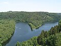
View from the dam of the Rappbode dam

Normannstein Castle of Treffurt from

Market square in Creuzburg
.jpg)


.jpg)
literature
- Manfred Wolter: Adventure and leisure destinations - Lüneburg Heath, Harz, Weserbergland, Werra and Leinetal, Eichsfeld, Kyffhäuser and Thuringian Forest . Michael Imhof Verlag, Petersberg 2003, ISBN 978-3-935590-86-0 (175 p., Numerous illustrations; map; 24 cm). (No hiking guide!)
Web links
Individual evidence
- ↑ Henry Czauderna: The resin-Eichsfeld Thuringian Forest way. In: www.thueringen.info. Retrieved March 26, 2021 .
- ^ Sarah Hoffmann: Long-distance hiking trail Harz - Eichsfeld - Thuringian Forest (HET). In: waymarkedtrails.org. Retrieved March 26, 2021 .