
Rappbode dam
| Rappbode dam or Rappbodetalsperre | |||||||||
|---|---|---|---|---|---|---|---|---|---|
 |
|||||||||
|
|||||||||
|
|||||||||
| Coordinates | 51 ° 44 '24 " N , 10 ° 53' 36" E | ||||||||
| Data on the structure | |||||||||
| Construction time: | 1952-1959 | ||||||||
| Height above valley floor: | 90 m | ||||||||
| Height above foundation level : | 106.0 m | ||||||||
| Height of the structure crown: | approx. 427 m above sea level NHN | ||||||||
| Building volume: | 860,000 m³ | ||||||||
| Crown length: | approx. 415 m | ||||||||
| Crown width: | 12.50 m | ||||||||
| Base width: | approx. 78 m | ||||||||
| Power plant output: | 5.4 MW | ||||||||
| Data on the reservoir | |||||||||
| Altitude (at congestion destination ) | 423.6 m above sea level NHN (summer) / 421.5 m above sea level NHN (winter) | ||||||||
| Water surface | 3.9 km² (390 ha) | ||||||||
| Total storage space : | 109.08 million m³ or 113 million m³ |
||||||||
| Catchment area | 114.8 / 269.0 km² | ||||||||
 |
|||||||||


| |
Location of the Rappbode dam in the Harz Mountains |


The Rappbode reservoir or Rappbodetalsperre is a 1952 erected to 1959, from the dam , waterworks , water power station and reservoir existing dam in the resin , particularly in the urban area of the upper resin on the chunks in the district resin in Saxony-indication is.
Its maximally 106.0 meter (m) high dam, the highest in Germany , especially docks the Rappbode and its tributary Hassel to the 3.9 square kilometer (km²) large Rappbodestausee , which with 109.08 or, according to other information, 113 million . Cubic meters (m³) is the largest resin reservoir in terms of volume. The Rappbode dam, together with the Great Dhünntalsperre, is one of the two largest drinking water dams in Germany.
The Rappbode dam, together with other valley and pre-dams and retention basins, forms the Rappbode dam system for flood protection in the eastern Harz, protecting the villages below its dam, especially on the Rappbode, and also providing drinking water and electricity to many localities.
Geographical location
The Rappbode dam is located in the Lower Harz in the Harz / Saxony-Anhalt Nature Park . On the Rappbode it is located between the somewhat distant localities of Elbingerode in the north-west, Blankenburg in the north-north-east, Thale in the east-north-east and Hasselfelde in the south.
Dam wall
location
The shut-off building of the dam is a gravity dam about 1.9 kilometers (km) southeast of the district Neuwerk the village Höhlenort Rübeland and about 2 km west-southwest of Thaler hamlet Wendefurth immediately southwest of the air side lying reservoir Wendefurth ( 351.9 m above sea level. NHN ). On the top of the wall runs the state road 96, which branches off southeast from the nearby federal road 81 (Wendefurth – Hasselfelde) , which runs directly northwest of the wall through a 219 m long tunnel built between 1954 and 1958 and renovated in 2001/2002 on the eastern flank of the Nickelsberg ( 488.2 m ) and in a north-west direction to Rübeland on federal road 27 (Blankenburg – Elbingerode). The valve and winch house with the operating devices is located on the southeast end of the dam .
history
The first considerations for the construction of dams and flood protection walls existed as early as 1891. The first planning referred to a 150 m high dam in the valley of the Bode above Thale , whose reservoir with 150 million m³ capacity the villages Wendefurth , Altenbrak and Treseburg and the worth seeing Bodetal would have fallen victim. In the project planning completed in 1938, the flooding of localities was dispensed with, several dams were planned for this.
Construction work on the Rappbode dam, including the opening of the quarry in the Möhrental, began as early as the Second World War (1939–1945). The foundation of the dam wall was excavated, sealing work was carried out in the subsoil and in the valley fields (especially the water-side sealing curtain ), the cable car to and from Hüttenrode required for cement transport was built and the diversion tunnel, which was intended to divert the Rappbode during the construction period and later as a bottom outlet, with the Inlet structure and gun shaft completed by August 1940 so that the river could be diverted. In May 1942 the work was stopped for reasons of war.
During the GDR era , the dam project was revived and expanded to include drinking water. The original layout was retained; however, the technology has been adapted to new findings in dam construction. The foundation stone for the dam was laid on September 1, 1952. The construction work was carried out with the participation of the West German construction company Polensky & Zöllner .
On October 3, 1959, the dam was handed over to its destination. Since then there has been an inscription (right / left) on both sides of the south-eastern, wall-side tunnel portal of the L 96, which also leads over the wall:
“The Rappbode dam - a large building of socialism. Laying of the foundation stone on the Day of Peace 1952 - handed over on October 3, 1959 on the occasion of the 10th anniversary of the German Democratic Republic "
"The socialist production conditions of our workers 'and farmers' state / The great achievements of the workers, technicians and engineers involved in the construction were the basis for the creation of this work / Recognition and thanks to the builders"
Between 1995 and 2009 the dam was renovated . The weathered concrete of the street on the top of the wall was renewed and the emblems of the GDR located directly above the aforementioned inscriptions were replaced by circular objects.
Data
The almost completely straight weight dam, which was built from 1952 to 1959 and dams the Rappbode by its own weight, is around 415 m long, at its crown 12.50 m and at the base around 78 m wide. It is about 90 m high above the valley floor and 106.0 m above the foundation floor . Your foundation height is about 321 m above sea level. NHN and the building crown at around 427 m above sea level. NHN . The volume of the structure contains around 860,000 m³ of concrete . The wall consists of 30 segments (fields) with a maximum segment width of 16 m. The flood relief consists of a free wall crown overflow with a total width of 64 m, which is divided into nine fields by eight intermediate pillars and can drain 120 m³ of water per second at an overflow height of 1.10 m.
Waterworks and hydroelectric power station
The dammed water is primarily a drinking water reserve, which towns northeast and east of the Harz Mountains can access. The Elbaue-Ostharz long-distance water supply transports the drinking water to the region . Their pressure lines run to Aschersleben , Halberstadt , Bernburg (Saale) , Halle (Saale) and even Leipzig . A 3.1 km long, mostly underground water tunnel leads from the dam to the waterworks near Wienrode , where drinking water treatment takes place. The water quality is extremely good, the water hardness averages 3 ° German hardness. This makes the water particularly suitable for use in steam generation and washing systems, but it also has considerable advantages in domestic use due to the lack of tendency towards calcification.
As part of its hydroelectric power station, the dam is also used to generate electricity using a water turbine operated by E.ON Avacon with an output of 5.4 MW .
Reservoir
location
The Rappbodestausee lies almost entirely in the area of the town of Oberharz am Brocken ; only a part of the reservoir near the dam, including the southeast part of the dam, belongs to Thale . It is located between the federal road 81 (Wendefurth – Hasselfelde) in the southeast and the somewhat distant federal road 27 (Blankenburg – Elbingerode) in the northwest, with the state road 96 running between the two federal roads over the dam and through the tunnel to the north-west of it. The dammed flowing water is the Rappbode , a southwest tributary of the Bode in the catchment area of the Elbe ; also lead the Hassel which directly upstream Hassel Auxiliary Dam flows, and many small streams, some of which do not lead all year water in the reservoir. Downstream lie along the now accumulated with water Rappbodetals left side of the reservoir, the brake heads ( 492.7 m ), the Monks heads ( 490.7 m ) and the nickel Berg ( 488.2 m ) and right-hand, Raven stones (about 510 m ), the Gitzhügel ( 481.8 m ), the Eichenberg (approx. 520 m ) and the Rotestein (approx. 505 m ). In the southern part of the narrow tree-forest reservoir lapped the water usually rises in Südufer- and Eichenberg close Präzeptorklippe .
Natural allocation
The dam is located in the natural spatial main unit group Harz (no. 38) and in the main unit Lower Harz (also called Lower Harz plateau ; 382) in the subunit Hasselfelder plateau (382.2).
Data
The surface of the reservoir is about 3.9 km². The reservoir extends in a south-west-north-east direction for about 9 km and is usually only a few hundred meters wide. According to various statements, it has 109.08 or 113 million m³ total storage space . Its target is 423.6 m above sea level. NHN in summer and 418.32 m above sea level. NHN in winter; its highest storage target for a flood that occurs on average once every 1000 years is at 424.68 m above sea level. NHN . The catchment area of the reservoir is 114.8 km² within the framework of that of the Rappbode and 269.0 km² due to the 1,795 m long transfer tunnel that leads through the elongated Trogfurter Berg , together with the catchment area of the Königshütte an der Bode reservoir 154.2 km² additional catchment area result. The mean inflow volume is 1.49 m³ / s, the annual transfer volume (from the Königshütte reservoir) a maximum of 45 million m³ and the annual outflow 47 million m³.
Protected areas
On the south bank of the central part of the Rappbodestausees lies the nature reserve (NSG) Eichenberg ( CDDA -Nr. 318327; 2000 designated; 57 hectares ). In the west an eastern part of the NSG Harzer Bachtäler extends to the shore near the influence of the Rappbode in the reservoir (CDDA No. 318505; 1998; 11.04 km² ). The reservoir is located entirely in the Harz and Vorländer landscape protection area (CDDA no. 20784; 1968; 1587.86 km²). Parts of the fauna-flora-habitat area Bodetal and deciduous forests of the Harz border near Thale (FFH no. 4231-303; 57.73 km²) extend to the south bank and those of the bird sanctuary in the Northeast Lower Harz (VSG No. 4232-401; 169.88 km²).
Fish fauna
In the Rappbodestausee there are mainly brown trout , rainbow trout , pike , perch , pikeperch , eel , vendace , carp , tench and numerous white fish . Especially pike and carp can reach huge weights there.
gallery
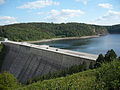
View of the dam from the observation deck

Upper control corridor inside the wall
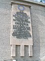
Right inscription on the south-eastern, wall-side tunnel portal ( Landesstraße 96), 2006
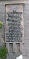
Left inscription on the south-eastern, wall-side tunnel portal (Landesstraße 96), 2006


Upstream and downstream locks
These barriers are upstream or downstream of the Rappbode dam:
- Almond wood dam as a pre- dam for the Kalten Bode : flood protection and retention of debris and nutrients,
- Transfer dam Königshütte an der Bode shortly after the confluence of the Warmer Bode and Kalter Bode in Koenigshütte : partial drainage of ground water in a transfer tunnel to the Rappbode dam ( drinking water extraction),
- Rappbode pre-barrier as a pre-barrier of the Rappbode : debris and sludge retention as well as nutrient retention,
- Hassel reservoir as a preliminary barrier for the Hassel : debris and sludge retention as well as nutrient retention,
- Downstream is the Wendefurth dam on the Bode: flood protection, compensation basin for the Rappbode dam and underwater basin for the Wendefurth pumped storage plant .
leisure
Hiking and excursion destinations
The Hasselfelde - Rübeland hiking trail (HK 27) leads over the dam . A few kilometers to the northwest, this path crosses the Harzer Hexenstieg, which runs north past the Wendefurth dam and in sections in the Bode valley . Excursion destinations in the vicinity include, for example, the Rübeland stalactite caves with the oldest show cave in Germany, the western town of Pullman City , the Harz köhlerei Stemberghaus with the charcoal factory and the Büchenberg show mine .
Double rope slide and pedestrian suspension bridge
A double rope slide and a pedestrian suspension bridge are located above the part of the reservoir of the Wendefurth dam that adjoins the air side of the Rappbode dam :
The Megazipline double cable slide , opened in 2012 and the longest in Europe, runs around 100 m northeast of the dam . It is about 1000 m long and hangs a maximum of 120 m above the water. People hanging in a belt system can slide down there.

The Titan RT pedestrian suspension bridge, which opened in 2017, is located about 50 m to the northeast and parallel to the dam . At 458.5 m, the 483 m long structure is probably the second longest freely suspended section of all pedestrian suspension bridges in the world. From the bridge hanging 100 m above the reservoir of the Wendefurth dam, bungee jumping is possible with the Gigaswing 75 m deep. The weight of the rope bridge is 118 tons.
See also
References and comments
- ↑ a b c d e f g h i j k l m n o p q r s t Information board Rappbode-Talsperre , with information and photos, on 2.bp.blogspot.com
- ↑ a b c d e f g h i j k l m n Talsperrenmeisterei des Landes Sachsen-Anhalt (ed.): Talsperren in Sachsen-Anhalt , self-published Talsperrenmeisterei LSA, Blankenburg, 1994.
- ↑ a b c d e f Rappbodetalsperre… (and other dams) in the north storage area , with information and photos, on talsperren-lsa.de
- ↑ a b c Press release The Rappbodetalsperre: a magnet for visitors even after 50 years ( memento of the original from March 4, 2016 in the Internet Archive ) Info: The archive link was inserted automatically and has not yet been checked. Please check the original and archive link according to the instructions and then remove this notice. on asp.sachsen-anhalt.de
- ↑ a b c Catchment area of the Rappbode dam without (114.8 km²) and with (269.0 km²) transition from the Königshütte dam on the Bode
- ↑ Tunnel at the Rappbodetalsperre , on dup-bs.de
- ↑ a b The history of the origins of the "Bode dams" system with information and photos, on harzkaleidoskop.de
- ↑ Note on the earlier border in the reservoir: Until December 31, 2009, the border between the former cities and the villages of Elbingerode and Hasselfelde , which now belong to Oberharz am Brocken, ran from the confluence of the Rappbode to the dam through the Rappbodestausee
- ↑ Jürgen Spönemann: The natural space units on sheet 100 - Halberstadt , Bad Godesberg, 1970
- ↑ a b Map services of the Federal Agency for Nature Conservation ( information )
- ↑ Fishing at the Bodetalsperren , on harz-paradies.de
- ↑ a b Megazipline double rope slide , accessed on April 27, 2017, from harzdrenalin.de
- ↑ Suspension bridge in the Harz Mountains before the opening - from May onwards, the route will fluctuate across the Rappbodetal ( memento of the original from April 28, 2017 in the Internet Archive ) Info: The archive link was automatically inserted and not yet checked. Please check the original and archive link according to the instructions and then remove this notice. , dated April 5, 2017, accessed on April 27, 2017, at mdr.de
- ↑ New attraction in the Harz Mountains: the world's longest suspension rope bridge has opened. May 7, 2017. Retrieved December 26, 2017 .
Web links
- Rappbode dam. In: Structurae
- Rappbodetalsperre ... (and other dams) in the northern reservoir area , with information and photos, on talsperren-lsa.de
- The history of the origins of the “Bode dams” system on harzkaleidoskop.de
- Pictures of the construction of the Rappbode dam (video)