
Leerort fortress
| Leerort fortress | ||
|---|---|---|
 Leerort fortress in 1632 |
||
| Creation time : | 1435 | |
| Castle type : | River castle | |
| Conservation status: | Ramparts | |
| Standing position : | Sovereign castle | |
| Construction: | Brick | |
| Place: | Empty place | |
| Geographical location | 53 ° 12 '42.7 " N , 7 ° 25' 35.1" E | |
| Height: | 2 m above sea level NHN | |
|
||

The fortress Leerort was a late medieval river castle and fortress in Leer , which was of outstanding importance for East Frisian history . On the strategically located headland between the rivers Ems and Leda, Hamburg merchants of the Hanseatic League built the fortress Leerort in 1435, which was expanded from 1453 by the East Frisian counts and lords to become the strongest fortress in East Frisia . From 1611 it served the Dutch garrison as quarters.
location
The fortress is strategically located on a headland at the mouth of the Leda in the Ems , about 3 km southwest of Leer in East Frisia . The fortress was built on angled marshland , which here reaches a height of 2 m. The geological conditions determined the development, which is divided into the upper and lower fortress. This was built on stable ground. The moat system (now silted up) marks unsound soil. Due to its low location at the confluence of two rivers, the fortress was damaged several times by storm surges.
history
prehistory
In the 15th century, East Frisia was not subject to any single rule and was divided into different spheres of power by local chiefs . In the course of the 14th century they had taken over positions of power in East Frisia after the old egalitarian constitution from the time of the Frisian Freedom had visibly fallen into disrepair. Towards the end of the 14th century the chiefs became increasingly involved in power struggles. This initially remained a local problem. After the Vitalienbrüder had been expelled from the Baltic Sea island of Gotland by the Teutonic Order in 1398 , they were accepted by some of the East Frisian rulers who used them as a force. Thereupon the Hanseatic League saw itself threatened and sent several punitive expeditions to East Frisia. Parts of East Frisia, including Emden, were mainly occupied by Hamburg forces.
Construction of the first castle by the people of Hamburg and handover to the Counts of East Friesland
To secure its shipping, the Hanseatic City of Hamburg began to build a castle at the confluence of the Leda and Ems around 1435. This was an earth fortification with a stone round tower, as can still be seen today at the Stickhausen Castle, which was also built by the Hamburgers . For the construction of this facility, which lasted two months, parts of the destroyed were Focke Castle Focko Ukena used from Leer.
In 1453 the Hamburg garrison withdrew and the castle was handed over in good faith to the chief and later Count Ulrich Cirksena , which meant that the city formally remained in the possession of the Hamburgers and the Counts of East Friesland initially only kept it and on request should return to Hamburg. In the time of the count, East Frisia was divided into offices . The castle was the seat of Count Drosten and bailiff for the Leerort office, which included Leer with the Moormerland , the western Overledingerland and the Upper Rheiderland up to the current Dutch border. In 1493 Count Edzard I succeeded in redeeming Hamburg's rights and claims to the castle through payments and the granting of privileges. From 1501 he had this expanded considerably.
The siege of Leerort in 1514

In the Saxon feud , Edzard tried to extend his power to the province of Groningen , which was under the rule of the imperial governor of the Netherlands , Duke George of Saxony . This led to an open war that devastated entire areas of East Friesland. Heinrich I , who was allied with Georg of Saxony, entered East Friesland in 1514 with an army of 20,000 men and besieged the Leerort fortress, which was only defended by a few farmers and soldiers. For several days they shot at the fortress, which was badly damaged. On June 22nd, 1514, the besiegers asked the fortress commander, Johann von Soest, to surrender, but the latter refused. The next day the fortress was to be finally conquered. Shortly before a storm attack, one of those trapped managed to kill Duke Heinrich I on June 23, 1514 with a cannon shot. The troops, which had become leaderless as a result, then failed to storm the fortress and withdrew from East Frisia. To commemorate Heinrich's death, the troops set up the so-called Hartog Hinnerk Steen in Bagband .
Further expansion
During the reign of Enno II , Edzard I's successor, the castle was expanded from 1528 to 1531 into a fortress that was about twice as large. The main building of the castle was enlarged and received three bastions , the associated ravelin , a moat and a drawbridge. After Enno's death, his widow Anna , who ruled East Frisia as a guardian until her sons came of age, had a drosten house and two other watchtowers built. On January 11, 1558, the fortress was badly damaged by a storm surge and then rebuilt. The Great Zwinger was raised and a new port house (= gatehouse) was built on it at the drawbridge .
Countess Anna had abolished the primogeniture in East Friesland and stipulated that the government over the ruling territory should be carried out jointly by her three sons Edzard , Christoph and Johann after her reign . After Christoph's death, Edzard and Johann did not rule the country together. In fact, the country was divided until Johann's death. Edzard ruled eastern East Frisia from Aurich , while Johann von Leerort ruled over the offices of Emden Leerort, Greetsiel and Stickhausen . Immediately after taking office, he had the fortress strengthened on the waterfront. After Johann's death, the complex was expanded again in 1594 by building a new house or a new wing at the castle near the castle building.

In the course of the conflict between the East Frisian estates and the Counts of East Frisia, the Netherlands, as the protective power of the estates, quartered a garrison in Leerort in 1611. In the Osterhusischen accord , this occupation was subsequently legitimized on May 21 of the same year and stipulated that the Dutch should initially keep the fortress for five years, but the castle building remained the count's residence. From then on, the complex consisted of a count's and a military part, which were separated from each other. The Dutch soldiers were not allowed to enter the count's part of the fortress. The first Dutch captain was given the job of repairing the somewhat dilapidated facility immediately. Despite repeated requests to leave the fortress, the Dutch stayed in Leerort until 1744. The official seat was then moved to Leer. When East Frisia suffered great hardship during the Thirty Years' War under the troops of the Protestant military leader Ernst von Mansfeld , Leerort was the refuge of Count Enno III. who died in the fortress in 1625. In the 18th century, the strategic importance of the fortress gradually began to decline. For the first time, civilian residents also settled here. In 1712 the dilapidated castle, the former residence of the Counts of East Friesland, was demolished in the fortress. The orphanage in Esens was built with the stone. In 1720 the ramparts of the fort were partially leveled and the ditches were filled in with the earth to create gardens. The last time the fortress was expanded in 1744 in connection with the roll call war . When Carl Edzard , the last East Frisian prince from the house of Cirksena, died on May 25, 1744 , King Friedrich II of Prussia asserted his right of succession, which was regulated in the Emden Convention . After Friedrich guaranteed the repayment of outstanding loans to the Dutch by the East Frisian estates, the Dutch, under Major General Otto Georg Veldtmann, withdrew their garrison in Leerort. Parts of the inventory of the former garrison church were brought to the Bourtange fortress and the Esklumer church . After the Dutch had withdrawn, a Prussian company was quartered in Leerort in 1744.
Todays use


After the last Prussian company had left the strategically insignificant fortress in 1749, the entire complex was sold for demolition. The village of Leerort grew up on a part of the fortress . The rest is used for agriculture. A remnant of the ramparts of the former fortress have been preserved, especially the inner walling of the old fort, which was built by Enno II. The so-called new Contrescarpe (embankment of the fortress ditch ), whose shapes can be seen in the direction of the Ems, and the walls of the White Zwinger at the Großer Graben are also preserved. All other fortifications have disappeared.
An exhibition on the fortress is shown in a school built on the former castle wall in 1851 and no longer used. The ramparts in the foreland are freely accessible. There is a display board with a plan of the fortress and a cannon.
In 2011 there were small-scale excavations on the grounds of the fortress by archaeologists from the East Frisian landscape . They took place on the five meter high bastion of the White Zwinger , built by Enno II at the beginning of the 16th century . A one meter wide patrol path, which was paved with yellow bricks, was proven. It is a Dutch building material that was widely used in the 17th century.
The finds from the excavation, mainly ceramics from the late 16th and 17th centuries, are exhibited in the local museum in Leer .

Earthenware from the late 16th to early 17th centuries from the Werra region
FO: Leerort Fortress
AO: Leer Heimatmuseum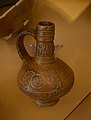
17th century stoneware
FO: Leerort Fortress
AO: Leer Heimatmuseum
Earthenware from the
17th century
FO: Leerort Fortress
AO: Leer Heimatmuseum
Earthenware from the
17th century
FO: Leerort Fortress
AO: Leer Heimatmuseum


literature
- Andreas Hüser: Bastion in second use in: Archeology in Lower Saxony , pp. 152–155, 2012
- Andreas Hüser: Search and find. A historical tour through the fortress Leerort . In: De Utmiener. Yearbook of the Heimatverein Leer , Volume 2, 2017, Schlösser und Burgen in and around Leer , pp. 83-104.
Web links
- Entry by Frank Both and Stefan Eismann about fortress Leerort in the scientific database " EBIDAT " of the European Castle Institute
- Description with finds
- Reconstruction drawing by Wolfgang Braun
Individual evidence
- ↑ a b c d Wilhelm Lange, Working Group of Ortschronisten der Ostfriesischen Landschaft : Leerort, Stadt Leer, District Leer (PDF; 879 kB), accessed on January 26, 2010.
- ↑ town of Leer: Chronicle data Leeraner Stadtgeschichte- Chronicle Data: 1000 - 1699 , accessed on January 26 of 2010.
- ^ Karl-Klaus Weber: Resolutions of the States General 1576-1625: Dutch Regests for the History of East Friesland and the City of Emden , Norderstedt 2007, ISBN 978-3-8334-8789-7 , p. 341.
- ^ Ostfriesen-Zeitung: A magnetometer is used in Leerort , viewed on May 29, 2011.