
Fischbach (Ems)
|
Fischbach Erzebach |
||
|
|
||
| Data | ||
| Water code | DE : 42892-14 | |
| location | District of Kassel , Hessen ( Germany ) | |
| River system | Weser | |
| Drain over | Ems (Eder) → Eder → Fulda → Weser → North Sea | |
| source | at Erzeberg 51 ° 15 ′ 58 ″ N , 9 ° 15 ′ 10 ″ E |
|
| Source height | approx. 344 m above sea level NHN | |
| muzzle | in Sand in the Ems Coordinates: 51 ° 14 ′ 25 ″ N , 9 ° 15 ′ 29 ″ E 51 ° 14 ′ 25 ″ N , 9 ° 15 ′ 29 ″ E |
|
| Mouth height | 252 m above sea level NHN | |
| Height difference | approx. 92 m | |
| Bottom slope | approx. 24 ‰ | |
| length | 3.8 km | |
| Catchment area | 6.35 km² | |
| Communities | Bad Emstal | |
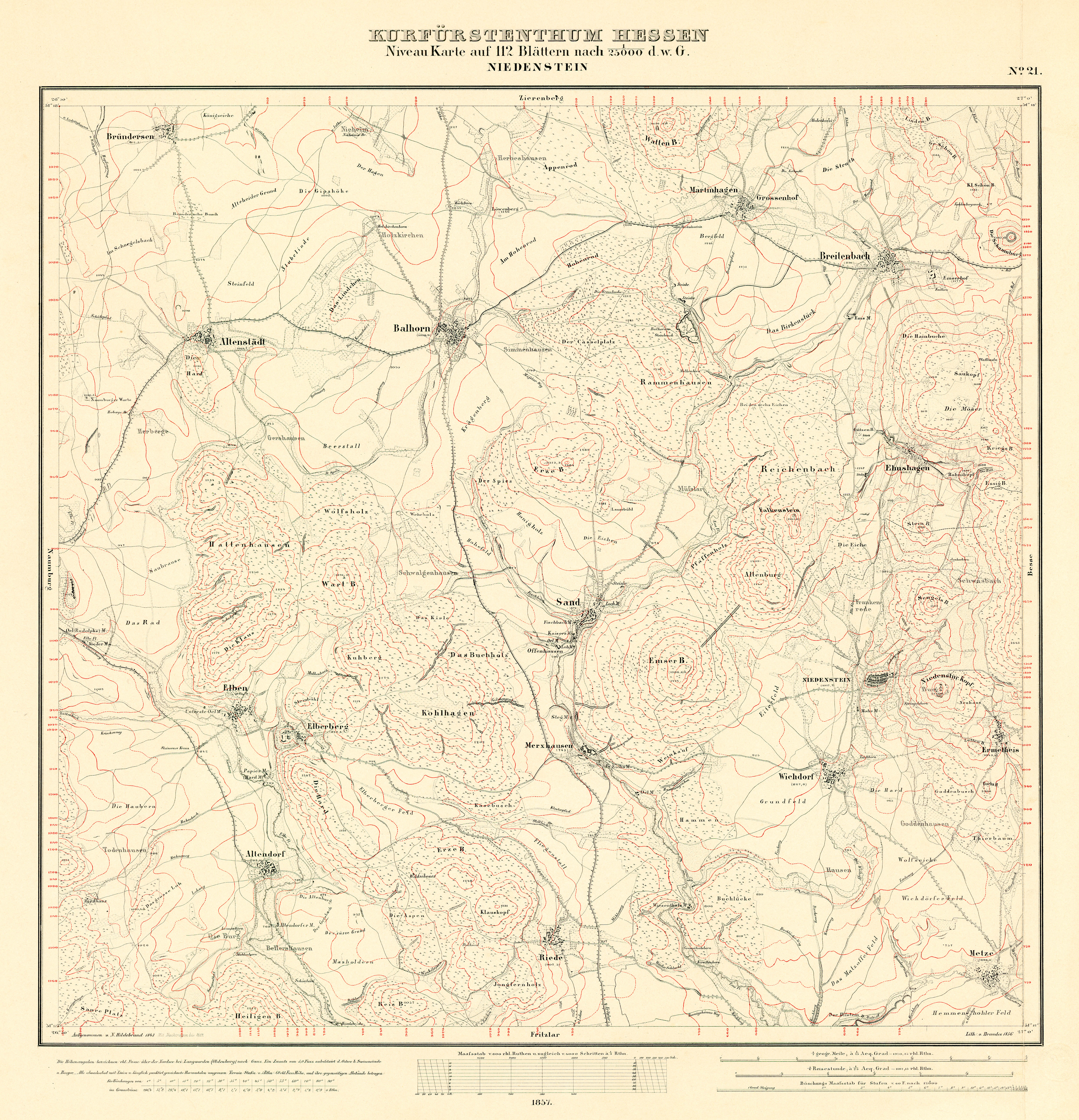
The Fischbach , also referred to as the Erzebach in the Hessian Ministry of Environment, Climate Protection, Agriculture and Consumer Protection , is an orographically right tributary of the Eder tributary Ems in the northern Hessian district of Kassel .
course
Its source is located at the northern foot of the Erzeberg, around 300 m south of the Erzeberg holiday resort belonging to Balhorn . The stream flows around the north-western flank of the Erzeberg in a long arc in a south-westerly direction. After about 1 km, not far east of the Balhorn train station, it crosses under the Kassel – Naumburg railway line , on which only the Hessencourrier's museum train runs today . The stream then runs in a generally southerly direction along the western flank of the Erzeberg, mostly on the edge of the forest or directly within the forest. In this section was the village of Visbach , first mentioned in a document in 1243 , which only appears as a deserted Fischbach in Merxhäuser Salbuch in 1544 ; the exact location of the abandoned settlement has not yet been clarified.
About 1.4 km after crossing under the railway line, the brook reaches the northwestern edge of Sand, flows there under Wolfhager Straße (Kreisstraße 110) and immediately afterwards takes on a small brook flowing from the west along the K 110. The Fischbach then bends slightly to the southeast and runs parallel to Wolfhager Straße or K 110 on the western outskirts of Sand for a distance of about 900 m westwards until it crosses under the Tränkeweg. Immediately to the north, above the Tränkeweg, the stream is dammed up to form an approx. 250 m long and 50 m wide pond. The last 600 m below the potions path initially flows the stream in elongated right turn south-east, passes under the Fischbachstraße where once stood the Fischbach mill, and then passes to the south, in order finally after passing under the Offenhäuser path immediately west of the Merxhäuser road in the EMS to open who has just passed under this street.
Natural space
The entire length of the Fischbach runs in the natural sub- unit “Istha level” (no. 341.34) in the main unit Ostwaldecker Randsenken (341) and the sub-unit Wolfhager Hügelland (341.3).
Footnotes
- ↑ a b Map services of the Federal Agency for Nature Conservation ( information )
- ↑ a b Water map service of the Hessian Ministry for the Environment, Climate Protection, Agriculture and Consumer Protection ( information )
- ↑ On the historical maps of the Electorate of Hesse from the middle of the 19th century, only the upper reaches of the Fischbach is referred to as the Erzebach ( Electorate of Hesse: level map on 112 sheets, Kassel 1840-1861 / 21: Niedenstein ). Old field names between the village Balhorn and the Bach - "Erzebachsfeld", "Erzebachshöhe" - confirm this name ( field names in Balhorn. Hessian field names. In: country Informationssystem Hessen (LAGIS).).
- ^ Fischbach (desert), Kassel district. Historical local dictionary for Hessen. In: Landesgeschichtliches Informationssystem Hessen (LAGIS).