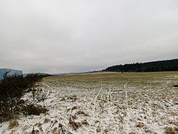
Schameder Airfield
| Schameder Airfield | |
|---|---|

|
|
| Characteristics | |
| ICAO code | EDGQ |
| Coordinates | |
| Height above MSL | 545 m (1788 ft ) |
| Transport links | |
| Distance from the city center | 1 km east of Schameder |
| Street |
|
| Basic data | |
| opening | 1926 |
| operator | Aviation Association Schameder-Wittgenstein eV |
| Start-and runway | |
| 10/28 | 750 m × 30 m grass |
The airfield Schameder located in Erndtebrücker district Schameder in Siegen-Wittgenstein . It is classified as a special landing site .
history
The site has been used for flying since 1926. The airfield is operated by the Schameder-Wittgenstein aviation club.
Infrastructure and use
The airfield has a 750 m long grass runway.
Among other things, glider flights are carried out on the site . These are favored by good thermal conditions.
Trivia
Other events such as choir concerts or concerts with 3000 spectators take place at the airfield.
See also
Web links
- Website of the Schameder-Wittgenstein Aviation Association
- Aeronautical map for Schameder Airfield on SkyVector.com
Individual evidence
- ↑ Schameder Airfield. In: naturpark-sauerland-rothaargebirge.de. Retrieved September 3, 2017 .
- ↑ The finest choral music is played in the blue hangar. In: wp.de. June 17, 2017. Retrieved September 3, 2017 .
- ↑ Anniversary: Bogga looks back on 25 years of band history. In: wp.de. August 26, 2017. Retrieved September 3, 2017 .