Friedrich Wilhelms Hut (Troisdorf)
|
Friedrich Wilhelms Hut
City of Troisdorf
Coordinates: 50 ° 48 ′ 3 ″ N , 7 ° 9 ′ 3 ″ E
|
|
|---|---|
| Height : | approx. 50 m |
| Residents : | 7176 (Dec. 31, 2016) |
| Postal code : | 53840 |
| Area code : | 02241 |
Friedrich-Wilhelms-Hütte is one of the twelve localities of Troisdorf in the Rhein-Sieg district in North Rhine-Westphalia .
history
In 1825 Johann Wilhelm Windgassen (1779-1852) began building the Friedrich-Wilhelms-Hütte (later Mannstaedt-Werke ), an ironworks on the Agger . From 1911, a workers' settlement was built in Friedrich-Wilhelms-Hütte at the instigation of Louis Mannstaedt (1839–1913). It is still called the " Black Colony " today.
Similarly, in Troisdorf-West, a “ red colony ” emerged. Both names refer to the color of the roof tiles that is still common today .
The first residents of Friedrich-Wilhelms-Hütte came from today's Cologne district of Kalk . Until the municipal reorganization , which came into force on August 1, 1969, Friedrich-Wilhelms-Hütte belonged to the municipality of Menden (Rhineland) in the Menden district , the area of which today largely coincides with the city limits of Sankt Augustin .
population
Individual parts of Friedrich-Wilhelms-Hütte are more densely built up than other parts of Troisdorf due to social housing. In Friedrich-Wilhelms-Hütte, not least because of this fact, some offers in the field of youth work and youth welfare are offered by the city administration as well as other non-profit associations. In addition to individual high-rise buildings, there are numerous attractive single-family housing estates in Friedrich-Wilhelms-Hütte, especially the Black Colony, the Officials Colony and the Green Colony, which is still under construction. The real estate market in Friedrich-Wilhelms-Hütte has remained stable for years. According to the standard land value card Boris.NRW, the standard land value here is around 195 euros per square meter (as of 2012) and is thus just below the average for the neighboring districts.
The proportion of foreigners in the district is 16.81 percent (as of June 30, 2014), making it the third highest after Oberlar (19.25 percent) and Troisdorf-Mitte (17.05 percent). The proportion of foreigners at the Roncallistraße primary school is around 50 percent, which is why the school has also decided to take special funding measures. In the years from 1970 to 1975, numerous high-rise residential buildings were built in Friedrich-Wilhelms-Hütte. Most of these buildings form the so-called flower settlement due to the local street names. Since the fall of the imperial ruins on the western side of Autobahn 59, one of these buildings has been the tallest in Troisdorf.
Infrastructure
A bypass road ensures the connection to the A 59 motorway .
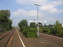
The Friedrich-Wilhelms-Hütte station on the right-hand Rhine route is next to the Mannstaedt works. It is served hourly by the Rhein-Erft-Bahn (RB 27) and the Rhein-Erft-Express (RE 8). In the course of the S-Bahn extension to Bonn-Oberkassel , the previous station will be replaced by a new S-Bahn stop.
Famous pepole
- Robert Theodor Betz (* 1953), psychologist and author
- Otto Coninx (1871–1956), German-Swiss publisher
- Hans Jaax (1933–2000), German politician ( SPD )
- Konrad Repgen (1923–2017), German historian
- Uwe Göllner (* 1945), German politician (SPD), 1993–1998 Mayor of Troisdorf
- Emil Langen (1824–1870), 1846–1867 director of Friedrich-Wilhelms-Hütte, today's Mannstaedt-Werke
Web links
swell
- ↑ City portrait of the city of Troisdorf. Retrieved on September 14, 2017 ( Memento of the original from July 2, 2017 in the Internet Archive ) Info: The archive link was inserted automatically and has not yet been checked. Please check the original and archive link according to the instructions and then remove this notice.
- ^ Website of the city of Troisdorf, district Friedrich-Wilhelms-Hütte , accessed on November 21, 2016
- ↑ Martin Bünermann: The communities of the first reorganization program in North Rhine-Westphalia . Deutscher Gemeindeverlag, Cologne 1970, p. 85 .

