Fyresdal
| coat of arms | map | |
|---|---|---|

|
|
|
| Basic data | ||
| Commune number : | 3823 | |
| Province (county) : | Vestfold and Telemark | |
| Administrative headquarters: | Moland | |
| Coordinates : | 59 ° 10 ′ N , 8 ° 1 ′ E | |
| Surface: | 1,280.13 km² | |
| Residents: | 1,287 (Feb 27, 2020) | |
| Population density : | 1 inhabitant per km² | |
| Language form : | Nynorsk | |
| Website: | ||
| politics | ||
| Mayor : | Erik Skjervagen ( Ap ) (2011) | |
| Located in the province of Vestfold og Telemark | ||

|
||
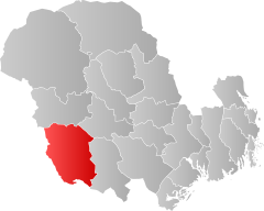
Fyresdal is a Norwegian municipality in the southwest of the Telemark region of the Fylke Vestfold og Telemark . The municipality has 1287 inhabitants (as of February 27, 2020). The seat of the administration is in the locality Moland , which is also called Fyresdal.
geography
Fyresdal borders in the south and west on the neighboring province of Agder , in the east on the municipality of Nissedal and in the north on Kviteseid and Tokke .
Most of the commune is hilly with heights between 600 moh. and 900 moh. The highest elevation in the area of the commune is the Napuren in the northeast with 1284.2 moh. In the center of Fyresdal is the lake Fyresvatn , which has a length of 26 kilometers. On the border with Tokken lies the Skredvatn and in the south the Birtevatn and the Nesvatn . The watercourse Fyresdalsvassdraget, which is part of the Arendalsvassdraget , runs through the municipality .
Fyresdal's population has been declining since around 1860. In the decade from 2009 to 2019, the population had shrunk by 6.9 percent. The largest town is the administrative center of Fyresdal with 387 inhabitants (as of 2019) at the northern end of Fyresvatn. The inhabitants of the municipality are called Fyresdøl , the official written language is Nynorsk as in the surrounding municipalities .
Riksvei 355 runs along Fyresdalsvassdragets and connects to Telemarksvegen and Riksvei 38. There is an airport in Verpe, north of the village of Fyresdal .
economy
Both the country - as well as the forestry play an important role for the community. Many of the farmers keep sheep . On average, between 35,000 and 40,000 cubic meters of wood are harvested each year. Due to the mountain landscape and the fishing and hunting opportunities in the municipality, the importance of tourism is also growing .
There are eleven power plants in Fyresdal , although they have a relatively low annual production of 362 gigawatt hours.
history
Until December 31, 2019, Fyresdal was part of the Telemark Province . As part of the regional reform in Norway, this was transferred to the newly created province of Vestfold og Telemark .
In the place are the rune stone from Berge and the Skeisteinen . The Prime Minister appointed by the German occupation, Vidkun Quisling, lived for the first six years in Fyresdal, where his father was a pastor.
Personalities
- Vidkun Quisling (1887–1945), officer and politician
Web links
- Fyresdal in the store norske leksikon (Norwegian)
- Facts about Fyresdal from Statistisk sentralbyrå (Norwegian)
Individual evidence
- ↑ Statistisk sentralbyrå - Befolkning
- ↑ Høyeste fjelltopp i hver commune. Kartverket, September 1, 2015, accessed February 27, 2020 (Norwegian Bokmål).
- ↑ Innbyggjarnamn. Språkrådet, accessed February 27, 2020 (Norwegian).
- ↑ Forskrift om målvedtak i kommunar and fylkeskommunar (målvedtaksforskrifta) - Lovdata. Lovdata, accessed February 27, 2020 (Norwegian).
- ^ Fyresdal Airfield. Fyresdal Flyplass, accessed on February 27, 2020 .
- ↑ Nye kommune- og fylkesnummer fra 2020. Regjeringen, October 27, 2017, accessed on February 27, 2020 (Norwegian).
