Kviteseid
| coat of arms | map | |
|---|---|---|

|
|
|
| Basic data | ||
| Commune number : | 3821 | |
| Province (county) : | Vestfold and Telemark | |
| Administrative headquarters: | Kviteseid | |
| Coordinates : | 59 ° 21 ′ N , 8 ° 30 ′ E | |
| Surface: | 708.47 km² | |
| Residents: | 2,403 (Feb 27, 2020) | |
| Population density : | 3 inhabitants per km² | |
| Language form : | Nynorsk | |
| Website: | ||
| traffic | ||
| Street: | E 134 ; Rv. 41 ; Fv. 38 | |
| politics | ||
| Mayor : | Bjørn Nordskog ( Sp ) (2019) | |
| Located in the province of Vestfold og Telemark | ||

|
||
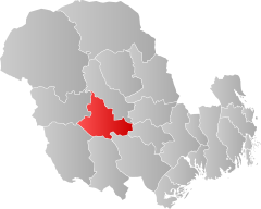
Kviteseid is a Norwegian municipality in the Telemark region in Fylke Vestfold og Telemark with 2403 inhabitants (as of February 27, 2020). Kviteseid is located on the central part of the Telemark Canal and includes the eastern part of the Bandak and Kviteseidvatnet and the western part of the Flåvatnet , as well as the valleys in the northern part, including Morgedal . In addition, Vrådal lies in the south on Vråvatn and the northern part of the Nisser . The seat of the administration is in the village of the same name.
local community
Surname
The name of the municipality goes back to the 14th century. About Huitisæiðes, Huitisæidi, the name changed to Hvítiseið in the Middle Ages. The first part of the name Hvítir means "white / the white", which was probably an earlier name of the Kviteseidvatnet. “-Eid” in the second part of the name means isthmus and probably refers to the isthmus between Kviteseidvatnet and Bandak.
coat of arms
The municipality's coat of arms (approved in 1987) consists of a black lock shield on a gold background. The subject is a picture of the castle Shield on the door of one of the oldest Loft ( storehouse ) of the community from Tele Markhof Tveitloftet from Tinn dating from 1350, which today in Kviteseid Bygdetun is seen. The coat of arms was designed by the artist Daniel Rike.
The reason for choosing the motif is:
“Låsskiltet symbolizes the marked out of folk cultures, bygdekunsten and bygde-tradisjonane in the municipalities as vi finn bevara på Bygdetunet. The knot sterk and god symbols to dør, lås, nykjel and velfylt stabbur. With the motive of the communal authority for local tilknytning and identitet. "
“The castle sign symbolizes the peculiarity of folk culture, rural art and rural traditions in the community, which we find preserved in Bygdetunet. A strong and good symbolism is associated with doors, locks, keys and well-stocked storage rooms. With a lock shield as a motif, the city coat of arms will have a local connection and identity. "
Neighboring communities
Kviteseid is bordered by Seljord to the north, Nome to the east, Drangedal , Nissedal and Fyresdal to the south and Tokke to the west .
geography
Geographical location
The watercourses are deeply cut between steep mountains, which means that there are great differences in altitude. The rock of the mountains is part of the so-called basement in the entire municipality , consisting mainly of quartzite , amphibolite and gneiss in the north and granite in the south and east. The granite mountains are more rounded than the others. The highest mountain is Sveinsheii ( 1141 m above sea level ) and lies on the border to Fyresdal.
history
The old church of Kviteseid on Kviteseidvatnet is a stone church from the early Middle Ages in Romanesque style. It was built in 1150. Next to the church is the Kviteseid Bygdetun open-air museum with old buildings from the region. Brunkeberg Church, a wooden cruciform church from 1790, was restored in 1939. In Morgedal, a place where the Olympic torch was lit for the Winter Games in 1952 , 1960 and 1994 is the Norsk Skieventyr Ski History Museum and the Bjåland Museum .
population
Population development
From 1875 to 1946 the population of Kviteseid remained stable at around 3250 inhabitants. Subsequently, the number of inhabitants decreased until about 1970 and stabilized at about 2950. From the 1980s the number continued to decrease and in the period 1994-2004 with 6.9% to then 2622 inhabitants. This was the largest percentage population decline in all of Telemark Province during the period.
Most of the development is in and around the village and administrative center of Kviteseid, in Vrådal and in Morgedal .
Famous personalities
Sons and daughters of the church
- Olav Bjaaland , polar explorer
- Einar Landvik , Nordic skier
- Sondre Norheim , ski pioneer
- Solveig Muren Sanden , draftsman and illustrator
- Aslaug Vaa , author
- Dyre Vaa , sculptor
Economy and Infrastructure
traffic
Kviteseid was the natural center of Vest-Telemark at the time when the waterways were the routes to Skien . The European route 134 goes through Kviteseid. The Riksvei 41 from Kristiansand goes through the administration center and meets the E134 in Brunkeberg . Fv.38 leads from Steane to Eidstod together with Rv.41 and from Eidstod alone along the north side of Vråvatn to Åmot in Vinje . The Fv.355 connects Vråliosen with Fyresdal.
In summer there is a boat route on the Telemark Canal between Skien and Dalen .
economy
Agriculture
Agriculture and forestry are the main economic sectors in Vest-Telemark . Kviteseid has very steep terrain. Keeping animals is the most important part, but various fruit and berry growing operations are practiced in the lowlands near the lakes. Besides the large forests that belong to the Cappelen and Aall families in Ulefoss , most of the other forest areas are forests that belong to individual farms. Most of the industry is forest and forestry.
trade
In Kviteseidbyen, Morgedal and Vrådal there are various shops and businesses that do trade.
The municipality has many hotels and inns, most of which are in Kviteseidbyen and Vrådal.
Industry
There are some smaller wood processing companies, as well as larger workshops and construction companies.
tourism
The municipality of Kviteseid has both summer and winter tourism, with most of the winter visitors staying in Vrådal, as there is a small alpine ski area with the Vrådal Panorama.
education
Kviteseid has two so-called oppvekstsenter (kindergarten and 1st to 4th grade) in Vrådal and Brunkeberg. In Kviteseidbyen there is a kindergarten and a school up to the 10th grade.
The Kvitsund Gymnasium is located just outside the center. A Christian secondary school of the Norwegian Lutheran Mission with boarding school. It is one of the few private high schools in Norway
Culture and sights
Theaters and museums
- Kviteseid Bygdetun is one of the oldest open-air museums in Norway and has existed since 1907.
- Norsk Skieventyr is a museum and experience center which deals with the history of skiing and is located in Morgedal.
Churches
- Kviteseid gamle kirke (also: Kviteseid gamle kyrkje) is a stone church from around 1260.
- Kviteseid kirke is a stone church from 1916.
Regular events
- Kviteseidmarken is a market that takes place in mid-February every year. When the ice on the Sundkilen off Kviteseidbyen is thick enough, the highlight of the event, a horse race on the ice, a tradition that goes back to the 19th century, takes place there. Other cultural activities and market stalls are also included.
swell
- Store Norske Leksikon / SNL
- Kviteseid historielag Retrieved on July 14, 2020 (Norwegian Nynorsk)
- Kviteseid Municipality Accessed August 16, 2020 (Norwegian Nynorsk)
Individual evidence
- ↑ Statistisk sentralbyrå - Befolkning
- ↑ Norsk Stadnamnleksikon. Retrieved August 12, 2020 (Norwegian).
- ↑ Om communes - KVITESEID KOMMUNE. Retrieved July 13, 2020 (Norwegian Nynorsk).
- ↑ https://soge.kviteseid.no/lag/wp-content/uploads/Kulturminneplan-vedtatt-i-kom-styre-30012020Mindre-utg.pdf (Norwegian Nynorsk)
- ↑ Kvitsund Gymnasium - Mer hen study skills. Retrieved August 16, 2020 (Norwegian).
- ^ Norsk Skieventyr i Morgedal - Opplevelsessenter in Morgedal, Kviteseid. Retrieved July 14, 2020 (Norwegian).
- ↑ Kviteseidmarken - Marked / Martna in Kviteseid, Kviteseid. Retrieved August 16, 2020 (Norwegian).


