Midt Telemark
| coat of arms | map | |
|---|---|---|

|
|
|
| Basic data | ||
| Commune number : | 3817 | |
| Province (county) : | Vestfold and Telemark | |
| Administrative headquarters: | Bø | |
| Coordinates : | 59 ° 27 ' N , 9 ° 6' E | |
| Surface: | 518.51 km² | |
| Residents: | 10,444 (Feb 27, 2020) | |
| Population density : | 20 inhabitants per km² | |
| Language form : | Nynorsk | |
| Website: | ||
| politics | ||
| Mayor : | Siri Blichfeldt Dyrland ( Sp ) (2019) | |
| Located in the province of Vestfold og Telemark | ||

|
||
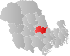
Midt-Telemark is a municipality in the Telemark region in the Norwegian province ( Fylke ) Vestfold og Telemark . It was created as part of the municipal reform in Norway on January 1, 2020 from the merger of Bø and Sauherad .
geography
The municipality borders on Notodden in the north, Kongsberg in the east, Skien and Nome in the south and Seljord in the west. In the municipality are two valleys of the Skiensvassdragets , a river system that flows into the North Sea. In the east of the commune, i.e. the former commune of Sauherad, there is a wooded, hilly area with a height between 500 and 800 moh. The western part, i.e. the former municipality of Bø, has greater differences in altitude. The highest point is the Jøronnatten with 1274.8 moh. on the border with Seljord and Notodden.
The number of inhabitants grew by 10.7 percent from 2010 to 2019. The population only increased in the then municipality of Bø, while that in Sauherad stagnated. In addition to the administrative center of Bø, the largest settlements are Gvarv , Folkestad and Nordagutu, and the population is concentrated in the two valley areas of the municipality. Nynorsk is the official language of the municipality.
The Sørlandsbanen runs through the municipality and stops in Bø and Nordagutu. The municipality is also connected to the rail network via Bratsbergbanen . In road traffic, the Riksvei 36 is of greater importance. It creates the connection to the Europastraße 18 and the Haukelivegen .
history
The municipality was created on January 1, 2020 by merging the two municipalities of Bø and Sauherad. In this merger, the villages of Angard and Hjuksebø were transferred from the former municipality of Sauherad to Notodden .
economy
Agriculture and forestry play an important role in the economy of Midt-Telemark. About two thirds of the agricultural area is used for growing maize. Parts of industrial production are also closely linked to agriculture and forestry. The village of Bø has had increasing importance in trade and in the public sector since the 1970s. There is also a campus of 2,016 from the Telemark University College , the University of Vestfold and the University Buskerud incurred University Southeast Norway (USN).
The Bø Sommarland amusement park is Scandinavia's largest water park in the municipality . Tourism takes place in both the winter and summer seasons.
coat of arms
The municipality's coat of arms showed three golden Hardanger fiddles on a blue background. It is supposed to represent the connection between Midt-Telemark and folk music.
Personalities
- Torgeir Augundsson (1801–1872), composer and virtuoso
- Regine Normann (1867–1939), writer
- Anders Haugen (1888–1984), American ski jumper
- Hans Kleppen (1907-2009), ski jumper
- Olav Haukvik (1928–1992), politician
- Kim Leine (* 1961), writer
Web links
- Midt-Telemark in the store norske leksikon (Norwegian)
- Facts about Midt-Telemark from Statistisk sentralbyrå (Norwegian)
Individual evidence
- ↑ Statistisk sentralbyrå - Befolkning
- ↑ Høyeste fjelltopp i hver commune. In: Kartverket. September 1, 2015, accessed on March 11, 2020 (Norwegian Bokmål).
- ↑ Forskrift om målvedtak i kommunar and fylkeskommunar (målvedtaksforskrifta) - Lovdata. In: Lovdata. Retrieved March 11, 2020 (Norwegian).
- ^ Kjell-Olav Hovde: Universitetet i Sørøst-Norge . In: Store norske leksikon . December 27, 2019 ( snl.no [accessed March 11, 2020]).
- ↑ Velkommen til campus Bø. Universitete i Sørøst-Norge, accessed on March 11, 2020 (Norwegian).
- ↑ Bø Sommarland Waterpark. Visit Norway, accessed March 11, 2020 .
