Gabrk (passport)
| Gabrk | |||
|---|---|---|---|
| Compass direction | southwest | Northeast | |
| Pass height | 549 m. i. J. | ||
| region | Slovenia | ||
| Watershed | (Senožečki potok → Raša → Branica → Vipava / Vipacco → Isonzo → Adriatic / Mediterranean ) | - ( underground → Timavo → Adriatic / Mediterranean ) | |
| Valley locations | Divača | Senožeče | |
| expansion | A1 , R409 | ||
| Built | Altstrasse | ||
| Mountains | Kras (Karst, Carso) / Vremščica | ||
| particularities | Karst area , drained underground | ||
| Map (Slovenia) | |||
|
|
|||
| Coordinates | 45 ° 42 ′ 16 ″ N , 14 ° 0 ′ 0 ″ E | ||
The Gabrk (German old also Gabrik ) is a ridge and 549 m. i. J. high pass crossing at Divača in Slovenia .
location
The Gabrk lies between Divača ( 435 m ) and the Senadolska dolina in the southwest and Senožeče (around 560 m ) in the northeast. It is the foothill of the Vremščica (Velika Vremščica 1027 m ) east, a foothill of the Snežnik massif (Krainer Schneeberg) in the Hochkarst , to the Kras (Karst plateau, Triester Karst) west. In the middle in the back lies the Klapf Čebulovica ( 643 m ), and east of it the saddle of the name. The western part is also called Divaški Gabrk , the eastern part above Dolnje Ležeče Ležeški Gabrk .
View from Ležeški Gabrk over the valley near Divača to the Gabrk airfield, behind it the karst hole of the Škocjan caves and the foothills of the Brkini
Hydrography, geology and nature
The Senožeče valley has the Senožečki potok, a brook that goes over the Raša and Branica to the Vipava and thus the Isonzo . The area north of the Gabrk is also part of the Karst. The Raša only carries water in heavy rain, and the hydrographic watershed is seen directly on the watercourse. The Gabrk itself and the dry valley to the south drain to the Škocjan cave system of the Reka and thus to Timavo near Montfalcone. On the south-western slope on the Straža ( 580 m ) near Brestovica pri Povirju, there are springs with Kal Globočaj and Studenci (Lempurjevka) .
The pass has been the boundary between the actual (Trieste) Karst, which in the modern breakdown of the natural geographic regions of Slovenia is included in the Primorje region (coastal region), and the Dinaric region ( Dinarski kras celinske Slovenije , Dinaric Karst inland). The region stands out against the flysch migration of the Vrhe to the north.

The area is made up of Paleozoic limestone and comparatively poor in caves. During excavations, however, old cave traces were found.
The Gabrk is made up of karst heather and pine forest. The area east of the pass already belongs to the Regijskega parka Škocjanske jame (Regional Park Škocjan Caves) .
History and traffic
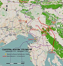
The fact that the pass is an old road is ensured by the prehistoric ring wall at Goli vrh north and by the course of the Roman road. The road from Tergeste (Trieste) to the trading post at Ocra (Razdrto) ran here , where it merged with the important Aquileia - Nauportus (Vrhnika) - Emona (Ljubljana) road via the Postojna gate , the Roman Amber Road and the main route to the Inner Balkans , bumped. This lost its importance after the establishment of the Via Gemina over the pass Inalpe Iulia / Ad Pirum (Hrušica) in the Birnbaumer forest , but remained locally important.
The route to the coast also remained important from the Middle Ages, when the area came under the Habsburg Empire in 1500 (the Habsburgs had been in the Duino rule since 1266 ). The later Kronland Krain emerged from this, with the main traffic axis running here into the Austrian coastal regions (littoral).
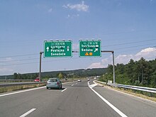
In 1989–95 the Avtocesta (motorway) A1 Spielfeld - Ljubljana - Koper was built here, first the section north, then south, together with the viaduct on Goli vrh. Directly south of the Gabrk at Divača is the node Gabrk the Avtocesta A3 according Sežana and Trieste or Venice .
The old Regionalna cesta (regional road) R409 Ljubljana - Logatec - Razdrto - Črni Kal only plays a subordinate role here.
To the south below is the small Divača airfield.
Individual evidence
- ↑ a b Ležeški gabrk and surroundings of the Škocjan caves. DOPPS - BirdLife Slovenia, Društvo za opazovanje in proučevanje ptic Slovenije
- ↑ catchment area Vodozbirna površina Timava dolvodno od škocjanskih Jam / Spodnji Timav ('catchment area Timav downstream of the Škocjan caves / Lower Timav'); ARSO: Atlas okolja ( Memento of the original from October 24, 2015 in the Internet Archive ) Info: The archive link was inserted automatically and has not yet been checked. Please check the original and archive link according to the instructions and then remove this notice. , Layer Water → Catchment area (English)
-
↑ Brestovica pri Povirju - kal Globočaj . slovenia.info;
Local protected area No. 1280 and natural formation No. 1785. - ↑ Dr. Baumbach: The Karst Flora. In: Die Alpenpost: Special-Organ für Alpenkunde, Naturwissenschaft, Touristik und Balneologie , Volume 6, 1874, S. 342 (whole article S. 342–346; Google eBook, complete view ).
-
↑ a b Tadej Slabe, T (1996) Karst features in the motorway section between Čebulovica and Dane. In: Acta Carsologica 25, 2005, pp. 221-240;
Martin Knez, Tadej Slabe: Cave Exploration in Slovenia: Discovering Over 350 New Caves During Motorway Construction on Classical Karst. Series Cave and Karst Systems of the World , Verlag Springer, 2015, ISBN 978-3-319-21203-6 , chapter Unroofed Caves Discovered on the Route Between Cebulovica and Dane , p. 57 ff ( limited preview in Google book search) . - ^ J. Horvat: Notranjska na začetku rimske dobe: Parti pri Stari Sušici, Ambroževo gradišče in Baba pri Slavini. In: Arh. vest. 46, 1995, p. 177 ff;
-
↑ Alma Bavdek: Locations from the late Republican and early Roman times in Razdrto at the foot of the Nanos. In: Arheološki vestnik , Volume 47 (1996), pp. 297-306; especially p. 304 ( article pdf , dlib.si; Weblink , ibid .; there p. 8);
Jana Horvat, Alma Bavdek: Okra. Vrata med Sredozemljem in Srednjo Evropo (Ocra. The gateway between the Mediterranean and Central Europe) . = Opera Instituti Archaeologici Sloveniae , Ljubljana 2009 ( online , website Inštitut za arheologijo ZRC SAZU, iza.zrc-sazu.si, Slovenian). - ^ Manfred Scheuch: Austria - Province, Empire, Republic. A historical atlas. Verlag Das Beste, 1994, ISBN 3-87070-588-4 , Der Weg zur Adria , p. 42 f.
- ↑ A1 Šentilj - SRmin. ( Memento of the original from November 8, 2017 in the Internet Archive ) Info: The archive link was inserted automatically and has not yet been checked. Please check the original and archive link according to the instructions and then remove this notice. DARS: O avtocestah> Nacionalni program izgradnje avtocest, esp. Razdrto - Čebulovica ( Memento of the original from June 4, 2012 in the Internet Archive ) Info: The archive link was inserted automatically and has not yet been checked. Please check the original and archive link according to the instructions and then remove this notice. and Čebulovica - Divača ( memento of the original from March 4, 2016 in the Internet Archive ) Info: The archive link was inserted automatically and has not yet been checked. Please check the original and archive link according to the instructions and then remove this notice. .


