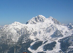
Gartnerkofel
| Gartnerkofel | ||
|---|---|---|
|
Gartnerkofel in winter |
||
| height | 2195 m above sea level A. | |
| location | Carinthia , Austria | |
| Mountains | Carnic main ridge | |
| Dominance | 5.3 km → Rosskofel | |
| Notch height | 665 m ↓ Nassfeld | |
| Coordinates | 46 ° 34 ′ 17 ″ N , 13 ° 18 ′ 13 ″ E | |
|
|
||
| rock | Sciliar dolomite | |
| Age of the rock | Ladinium | |
The Gartnerkofel is a two-peaked mountain (north summit 2195 m above sea level , south summit 2154 m above sea level ) in the Carnic Alps . It is located approx. 8 km southwest of Hermagor on the eastern edge of the Nassfeld and, together with the Trogkofel ( Italian Creta di Aip ) and Rosskofel (Italian Monte Cavallo ), forms the impressive mountain panorama for the largest Carinthian ski area.
geology
The Nassfeld and its surroundings are known for their carbon deposits . Here, in the Younger Carboniferous and the beginning Permian, lime and clay mud from the Tethys was deposited on an old mountain hull. In between, the area was dry again and again, as demonstrated by plant fossils in sandy slate and sandstone layers , as well as layers of anthracite up to one meter thick . Over a period of approx. 70 million years, 2.5 to 3 km thick deposits were created, the youngest parts of which (approx. 230 million years old) now form the summit of the Gartnerkofel. The top 500 m consists of light dolomite rocks , so-called Schlern dolomite , named after the mountain of the same name in the South Tyrolean Dolomites . The Schlern dolomite is the youngest rock in the Austrian part of the Carnic Alps. Under the dolomite lies a layer of shell limestone, which can be seen in small remnants in the vicinity of the Kühweger saddle. The unlayered dolomite weathered in a characteristic way into small pieces of rubble and gravel. As a result, the entire summit complex of the Gartnerkofel is interspersed with cracks, crevices and loosening zones, giving it its rough character.
Geotrail
As in other places in the Carnic Alps, Hans-Peter Schönlaub set up display boards for interested hikers on the Gartnerkofel and in the Garnitzenklamm on its northern flank as part of the Carnic Alps Geo Trail . They clearly show the different phases of mountain formation, the stratification of the rocks and other scientifically interesting information.
Ascent and via ferrata
The Gartnerkofel can be climbed from Nassfeld via an easy and well-marked hiking trail in around two hours. In good weather, not only the Gailtal and the surrounding mountains, but also the Großglockner and other glaciated peaks of the Hohe Tauern can be seen from the summit . Another ascent is the one over the west ridge, which however has some climbing points up to the 2nd level of difficulty.
On the west side just below the summit and not far from the Gartnerkofel mountain station, the Däumling via ferrata leads over around 150 meters in altitude.
flora
The “ Carinthian Wulfenie ” is endemic on the Gartnerkofel .


